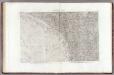
Maps of Nile Delta

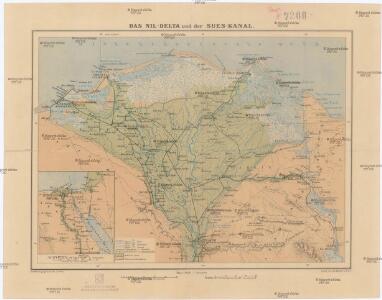
Das Nil-Delta und der Sues-Kanal
1 : 800000 Egypt Eduard Hölzel
Carte De L'Egypte et des Postes Militaires occupés et Fortifiés par les Français sous les ordres du Géneral en Chef Bounaparte, depuis leur invasion le 1. Juillet 1798, jusqu'à ce jour; Dressée d'après les relations fidelles des Chefs interceptées, et sur le compte qui en a eté rendu par les deserteurs
Kauffer, François
[Nil-Delta]
1 : 1000000 Alexandrie (Egypt) Mitterwallner, J.
Communications map of lower Egypt and the Fayum
1 : 300000 Egypt Survey of Egypt
Carte de la Basse, Égypte et du Canal Maritime de Suez
1 : 500000 Suezský průplav (Egypt) Desbuissons, Edouard Méa, Paul E. Andriveau-Coujon
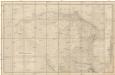
Das Nil-Delta und der Sues-Kanal
1 : 800000 Egypt Ed. Hölzel
163. Nile Delta, Suez Canal, Alexandria. The World Atlas.
1 : 750000 USSR (Union of Soviet Socialist Republics).
Das Nil - Delta und der Sues-Kanal
Carte hydrographique de la Basse Égypte et d'une partie de l'isthme de Suez
1 : 250000 Egypt Linant de Bellefonds, Louis Maurice Adolphe Schwaerzlé, J. Dépôt général de la guerre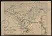
Carte de la Basse Egypte
1 : 1500000 Société de géographie de Toulouse Toulouse : Lith. Cussan Fils
Egypt.
1 : 900000 Rand McNally and Company
Europa.
1 : 15000000 Petermann, A.
Plan of the Operations of the British & Ottoman Forces in Egypt, From the 8th. of March to the 2d. of Sept.r 1801, when the French were Finally expelled from that Country
Neele, Samuel John Arrowsmith
[Kaart van het waterschap] : [tweede district]
1 : 100000 Annotatie geografische gegevens: Kaart geeft de Nijldelta weer tot iets ten noorden van Caïro [S.l.] : [Topografische Dienst Egypte]
Suez Canal Zone (1954)
Suez Canal Zone, MDR Misc 11944. Overprinted by 42 Svy Eng Reg Nov 1954. Originally classified Restricted. Great Britain. Army. Royal Engineers. Survey Engineers Regiment, 42nd. [S.l.] : [Survey Directorate, Middle East]
Specialkarte des Kriegsschauplatzes von Ismailia bis Cairo
1 : 270000 Káhira (Egypt) Hassenstein, Bruno Justus Perthes
Carte générale de l'Isthme 1869
1 : 200000 Suezský průplav (Egypt) Migerkov
Specialkarte des Kriegsschauplatzes von Alexandria bis Tanta
1 : 270000 Alexandrie (Egypt) Barich, C. Justus Perthes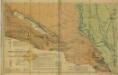
Cairo [Provisional map of the country North-west ] (1915)
Provisional map of the country north-west of Cairo : including the Wadi Natrun. Egypt. Maṣlaḥat al-Misāḥah. [Cairo] : Survey of Egypt
Karte der Gegend zwischen Belbes und Sues
1 : 200000 Egypt Schweinfurth, Georg Geographische Verlagshandlung Dietrich Reimer
Suez Kanal
1 : 100000 Suezský průplav (Egypt) Reichs-Marine-Amt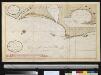
Afteekening van een gedeelte van de kust van Egipten vertoonende de haven van Alexandria ent land daer beoosten
Egypt Gerard van Keulen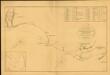
Chart of the Coast of Egypt, from Alexandria to the Western Branch of the Nile
Chart of the Coast of Egypt, from Alexandria to the Western Branch of the Nile; with the Bay of Aboukir, shewing the position of the French and English Fleets, at the Battle of the Nile, August 1, 1798. London : A. Arrowsmith.
35 Mansourah, San.
1 : 100000 Jacotin, Pierre, 1765-1827
36 Foueh, Damanhour.
1 : 100000 Jacotin, Pierre, 1765-1827
23 Lacs Amers.
1 : 100000 Jacotin, Pierre, 1765-1827
24 Le Caire, Belbeis.
1 : 100000 Jacotin, Pierre, 1765-1827
25 Ventre de la Vache.
1 : 100000 Jacotin, Pierre, 1765-1827
31 Canal de Suez.
1 : 100000 Jacotin, Pierre, 1765-1827