Maps of gmina Międzylesie

Senftenberg
1 : 75000 Králíky (Ústí nad Orlicí, Česko : oblast) Blaschke K. u. k. militär-geographisches Institut
Senftenberg
1 : 75000 Králíky (Ústí nad Orlicí, Česko : oblast) Blaschke K. u. k. militär-geographisches Institut
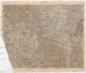
Senftenberg
1 : 75000 Králíky (Ústí nad Orlicí, Česko : oblast) Blaschke K. u. k. Militärgeographisches Institut
Senftenberg
1 : 75000 Žamberk (Česko : oblast) K. u. k. Militärgeographisches Institut
Žamberk
1 : 75000 Králický Sněžník (Česko a Polsko : pohoří) Vojenský zeměpisný ústav
Soubor přehledných map pro plánování a statistiku: 3957 – Žamberk

Kreis Habelschwerdt, Regierungs-Bezirk Breslau
1 : 100000 Králíky-oblast (Ústí nad Orlicí, Česko) Petters, H.
III. vojenské mapování 3957
1 : 75000
Žamberk
1 : 75000 Žamberk (Česko : oblast) Vojenský zeměpisný ústav
Žamberk
1 : 75000 Žamberk (Česko : oblast) Vojenský zeměpisný ústav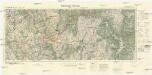
Mittelwalde-Kamnitz
1 : 100000 Międzylesie (Polsko : oblast) Reichsamt für Landesaufnahme-Reichskartenstelle
[Kartenblatt]
1 : 25000 Králíky (Ústí nad Orlicí, Česko : oblast) Reichsamt für Landesaufnahme
[Kartenblatt]
1 : 25000 Letohrad (Česko : oblast) Reichsamt für Landesaufnahme

III. vojenské mapování 3957/4
1 : 25000
III. vojenské mapování 3957/4
1 : 25000
III. vojenské mapování 3957/3
1 : 25000
[Gradkartenblatt]
1 : 25000 Králíky-oblast (Ústí nad Orlicí, Česko)

Gradkartenblatt
1 : 25000 Žamberk-oblast (Česko) Fromm, Hermann
[Gradkartenblatt]
1 : 25000 Morava (Česko) Vojenský zeměpisný ústav
III. vojenské mapování 3957/2
1 : 25000
III. vojenské mapování 3957/2
1 : 25000
Meßtischblatt 3381 : Rosenthal in Schlesien, 1919
1 : 250000 Rosenthal in Schlesien. - Aufn. 1882, hrsg. 1884, bericht. 1919. - 1:25000. - [Berlin]: Preuss. Landesaufnahme, 1919. - 1 Kt.
Meßtischblatt 3382 : Mittelwalde, 1919
1 : 250000 Mittelwalde. - Aufn. 1881, bericht. 1919. - 1:25000. - [Berlin]: Preuss. Landesaufnahme, 1919. - 1 Kt.
Idealer Plan von der Gegend zwischen Grulich, Rothwasser, Leipka und Lichtenau
Králíky-oblast (Ústí nad Orlicí, Česko)


III. vojenské mapování 3957/1
1 : 25000