Maps of Velykyi Bereznyi Raion

[Gradkartenblatt]
1 : 25000 Ukrajina
[Gradkartenblatt]
1 : 25000 Polsko
Nagyberezna.
from Spezialkarte der osterreichisch-ungarischen Monarchie.
Vel'ký Berezný
1 : 75000 Ukrajina Vojenský zeměpisný ústav
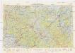
Vel. Berezné
1 : 75000 Ukrajina Vojenský zeměpisný ústav
Nagyberezna
1 : 75000 Ukrajina Militärgeographisches Institut
Nagyberezna
1 : 75000 Transkarpatien Geripp: Assist. Jersche u. Fldw. Martinek. Terrain: Offiz. Terlikowski u. Oberlt. Nyerges
III. vojenské mapování 4469
1 : 75000
Ulič
1 : 75000 Slovensko Vojenský zeměpisný ústav
Zemplénoroszi und Dydiowa
1 : 75000 Bieszczady Geripp: Feuerwkr. Sorè u. Aspr. Chlum. Terrain: Oberlt. Sachs u. Offiz. Hanusch
III. vojenské mapování 4369
1 : 75000
Zemplenoroszi und Dydiowa.; Spezialkarte der osterreichisch-ungarischen Monarchie.
from Spezialkarte der osterreichisch-ungarischen Monarchie. Austro-Hungarian Monarchy. Militärgeographisches Institut.,
Ruská a Dydiowa
1 : 75000 Polsko Vojenský zeměpisný ústav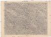
Ruská a Dydiowa
1 : 75000 Slovensko Vojenský zeměpisný ústav
C. Ungvár
Slowakei Ukraine Komitat Uschgorod
Normální mezinárodní letecká mapa.

Comitat Ungh
1 : 285000 Užhorod (Ukrajina)
Neubertova generální automapa Republiky československé
1 : 200000 Soukup, Jan V. Neubert a synové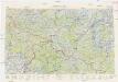
Neubertova generální automapa Republiky československé
1 : 200000 Soukup, Jan V. Neubert a synové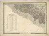
General-Karte des Königreiches Galizien und des Herzogthumes Bukovina

Stolice Zemplín a Užhorod
Komitat Zemplín, Komitat Uschgorod, ethnische Gruppe
Stolice Zemplín a Užhorod
Užhorod (Ukrajina)
Generalkarte von Zentraleuropa
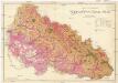
Podkarpatská Rus
1 : 225000 Podkarpatská Rus (Ukrajina) Gregor, František Novotný a Bartošek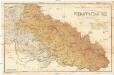
Podkarpatská Rus
1 : 225000 Podkarpatská Rus (Ukrajina) Gregor, František Novotný a Bartošek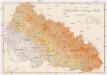
Podkarpatská Rus
1 : 225000 Podkarpatská Rus (Ukrajina) Gregor, František Novotný a Bartošek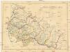
Podkarpatská Rus
1 : 300000 Podkarpatská Rus (Ukrajina) Referát min. veř. prací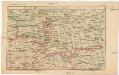
Strecke
Ivano-Frankivsk (Ukrajina) K. k. Österreichische Staatsbahnen
![[Gradkartenblatt]](https://images-2.georeferencer.com/images/iiif/791709284784/full/,300/0/native.jpg)

