Maps of Poland

TABULA NOVA POLONIAE et SILESIAE
1 : 1800000 Gdaňsk (Polsko) Goos, Abraham impreßa in aedibus Nicolaij Iohannis Vißcher
Generalkarte vom Königreich Preussen
1 : 1200000 Polsko Sotzmann, Daniel Friedrich Schneider u. Weiglischen Kunst und Buchhandlung
Generalkarte vom Königreich Preussen
1 : 1200000 Polsko Sotzmann, Daniel Friedrich Schneider u. Weiglischen Kunst und Buchhandlung
Mapa gęstości zaludnienia Polski
1 : 3000000 Polsko Lencewicz, Stanisław Uniwersytet Warszawski
Mapa samochodowa Polski

Novissima Poloniae regni Descriptio
1 : 1600000 Mollova mapová sbírka Janssonius, Johannes Janssonius, Johannes I
Karte vom Herzogthum Warschau, und den angrenzenden Staaten in IV Sectionen
1 : 650000 Polsko Engelhardt, Friedrich Bernhard Mare, Carl Simon Schropp & Comp.
German Empire 2.
1 : 1774080 Letts, Son & Co.
Lidová republika polská

Germany (Deutschland)
1 : 1760000 Polsko Walker, C. Baldwin & Cradock
Karte vom Königreiche Polen
1 : 3900000 Polsko Hamernik, Josef Lithographische Anstalt v. Zwettler & Nikl
L'Alemagne 2.
1 : 1800000 Rizzi Zannoni, Giovanni Antonio Bartolomeo, 1736-1814
Charte vom Königreiche Preussen dem Herzogthume Warschau und dem neuen Danziger Gebiethe
1 : 1510000 Gdaňsk-oblast (Polsko) Soltzmann, D. F. Geographischen Instituts

Germany, eastern border regions surface configuration
Relief shown by gradient tints. Includes most of western Poland. Includes location map. United States. Office of Strategic Services. Research and Analysis Branch. [Washington, D.C.] : R & A, OSS
Polsko, Prusy, Poznáňsko [sic]
1 : 3890000 Polsko
Novissima Poloniae Regni Descriptio. [Karte], in: Novus atlas absolutissimus, Bd. 1, S. 90.
1 Karte aus Atlas Janssonius Offizin
Charte von dem Königreiche Polen, den königl. preussischen Provinzen Ost und West- Preussen und Posen nebst dem Gebiete der freien Stadt Krakau
1 : 1180000 Krakov (Polsko) Weiland, Karl Ferdinand im Verlage des Geograph. Instituts
Charte von den Königreichen Preussen und Polen, dem Grosherzogthum Posen nebst dem Gebiete der freien Stadt Krakau. Nach dem am 3. May 1815 zu Wien zwischen Russland, Preussen und Oesterreich abgeschlossenen Tractate
Kongresspolen, Provinz Posen
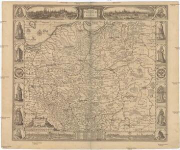
Polonia Regnum, et Silesia Ducatus
1 : 1600000 Mollova mapová sbírka Blaeu, Willem Janszoon Bleau, Willem Janszon
[Nordöstl. Deutschland und Polen]
[Allgemeiner Atlas über alle Theile der Erde in 29 Blättern] Ziegler, Jakob Melchior Top. Anstalt v. J. Wurster u. Comp.
Germany. Deutschland II.
1 : 1760000 Society for the Diffusion of Useful Knowledge (Great Britain)
Prussian Dominions.
1 : 1440000 Pinkerton, John, 1758-1826
Karte von den königl. preussischen Provinzen Preussen und Posen nebst dem kaiserlich russischen Königreiche Polen und dem Gebiete der freien Stadt Krakau
1 : 1370000 Gdaňsk (Polsko) Weiland, Karl Ferdinand Geogr. Institut
Karte von den königl. preussischen Provinzen Preussen und Posen nebst dem kaiserlich russischen Königreiche Polen und dem Gebiete der freien Stadt Krakau
1 : 1370000 Gdaňsk (Polsko) Weiland, Karl Ferdinand Mädel, J. im Verlage des geogr. Instituts
Karte von den Königl. Preussischen Provinzen Preussen und Posen nebst dem Kaiserlich Russischen Königreiche Polen und dem Gebiete der freien Stadt Krakau
1 : 1370000 Gdaňsk (Polsko) Weiland, Karl Ferdinand Mädel, J. Verlage des geogr. Instituts
Karte von den Königl. Preussischen Provinzen Preussen und Posen nebst dem Kaiserlich Russischen Königreiche Polen und dem Gebiete der freien Stadt Krakau
1 : 1370000 Gdaňsk (Polsko) Weiland, Karl Ferdinand Mädel, J. Verlage des geogr. Instituts
Preussen, Posen, Polen.
1 : 1370000 Weiland, C. F. (Carl Ferdinand), d. 1847
87-88. Poland. The World Atlas.
1 : 1500000 USSR (Union of Soviet Socialist Republics).