Maps of Dobřany
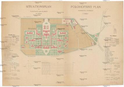
Situationsplan der Landes-Irren-Anstalt in Dobřan
1 : 3000 Dobřany (Plzeň-jih, Česko)
Dobrzan (Dobřany) - c1202-1-001 - Kaiserpflichtexemplar der Landkarten des stabilen Katasters
1 : 2880
Dobrzan (Dobřany) - c1202-1-009 - Kaiserpflichtexemplar der Landkarten des stabilen Katasters
1 : 2880
Dobrzan (Dobřany) - c1202-1-003 - Kaiserpflichtexemplar der Landkarten des stabilen Katasters
1 : 2880
Dobrzan (Dobřany) - c1202-1-011 - Kaiserpflichtexemplar der Landkarten des stabilen Katasters
1 : 2880
Dobrzan (Dobřany) - c1202-1-005 - Kaiserpflichtexemplar der Landkarten des stabilen Katasters
1 : 2880
Dobrzan (Dobřany) - c1202-1-007 - Kaiserpflichtexemplar der Landkarten des stabilen Katasters
1 : 2880
Dobrzan (Dobřany) - c1202-1-010 - Kaiserpflichtexemplar der Landkarten des stabilen Katasters
1 : 2880
Dobrzan (Dobřany) - c1202-1-006 - Kaiserpflichtexemplar der Landkarten des stabilen Katasters
1 : 2880
Dobrzan (Dobřany) - c1202-1-004 - Kaiserpflichtexemplar der Landkarten des stabilen Katasters
1 : 2880
Dobrzan (Dobřany) - c1202-1-008 - Kaiserpflichtexemplar der Landkarten des stabilen Katasters
1 : 2880
Dobrzan (Dobřany) - c1202-1-013 - Kaiserpflichtexemplar der Landkarten des stabilen Katasters
1 : 2880
Dobrzan (Dobřany) - c1202-1-012 - Kaiserpflichtexemplar der Landkarten des stabilen Katasters
1 : 2880
Dobrzan (Dobřany) - c1202-1-002 - Kaiserpflichtexemplar der Landkarten des stabilen Katasters
1 : 2880
[Kartenblatt]
1 : 25000 Chlumčany (Plzeň-jih, Česko : oblast) Reichsamt für Landesaufnahme
III. vojenské mapování 4150/2
1 : 25000
Gradkartenblatt
1 : 25000 Nýřany-oblast (Česko) Bulla, Eduard
Geologická mapa jižní části plzeňské pánve kamenouhelné


Podrobné mapy zemí Koruny české v měřítku 1:75.000 a mapa vzdáleností všech míst při silnici ležících - Plzeň - Nýřany - Stod. Průvodce statisticko-historický po všech místech na těchto mapách uvedených a rejstřík věcný názvů hor, potoků, řek, rybníků atd. Sešit 24. List 21,
1 : 75000
Podrobné mapy zemí Koruny české v měřítku 1:75.000 a mapy vzdáleností všech míst při silnici ležících
1 : 75000 Nýřany (Česko : oblast) Bělohlav, Josef F. Topič
Mapa okresu Plzeň
Mapa plzeňského okresu. Vlevo dole vysvětlivky značek, vpravo dole grafická měřítka.
Zastupitelský okres Plzeňský
Rukopisná mapa zastupitelského okresu Plzeňského. Vyznačeny jednotlivé obce a hranice jejich katastrů. Zaznamenána síť sídel, vodních toků a komunikační. Znázorněny mlýny a rozptýlené jednotlivé stavby. Vlevo dole grafické měřítko.
Pilsen und dessen Umgebung přehledka

Plzeň a okolí
1 : 75000 Plzeň (Česko : oblast) Vojenský zeměpisný ústav
Bischofteinitz und Nürschan
1 : 75000 Horšovský Týn (Česko : oblast) Mulacz, J. K. u. k. militär-geographisches Institut
Bischofteinitz und Nürschan
1 : 75000 Horšovský Týn (Česko : oblast) Mulacz, J. K. u. k. Militärgeographisches Institut
Bischofteinitz und Nürschan
1 : 75000 Horšovský Týn (Česko : oblast) K. u. k. Militärgeographisches Institut