Maps of okres Příbram

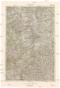
32°50° Praha
1 : 200000 Praha-oblast (Česko) Jech, J. Vojenský zeměpisný ústav
Generální mapa Protektorátu Čechy a Morava

Special-Karte des Prager Kreises
1 : 300000 Praha-oblast (Česko) Fr. Řiwnač
Střední Čechy

[Mapa okolí pražského]
1 : 215000 Praha-oblast (Česko) Brož, Josef A. Storch
Special-Karte des Prager Kreis resp. politi. Karolinenthaler Verwaltungsbezirkes
1 : 218000 Praha-oblast (Česko) Schmidt, Eduard Wend. Morauer
Special-Karte des Prager Kreis resp. politi. Karolinenthaler Verwaltungsbezirkes
1 : 218000 Karlín (Praha, Česko) Schmidt, Eduard Wend. Morauer
Special-Karte des Prager Kreis resp. politi. Karolinenthaler Verwaltungsbezirkes
1 : 218000 Praha-oblast (Česko) Schmidt, Eduard Wend. Morauer
Special-Karte des Prager Kreises
Praha-oblast (Česko) Schmidt, Eduard C.W. Medau
Special-Karte des Prager Kreises
Praha-oblast (Česko) Schmidt, Eduard C.W. Medau
Elektrárenský svaz okresů středočeských
1 : 200000 Čechy střední (Česko) Vojenský zeměpisný ústav
[Střední Čechy]
1 : 220000 Čechy střední (Česko) Wagner, Jan Eduard F. Kytka
Střední Čechy
1 : 220000 Čechy střední (Česko) Wagner, Jan Eduard F. Kytka
Special-Karte des Prager Kreis resp. politi. Karolinenthaler Verwaltungsbezirkes nach der politischen Eintheilung Böhmens v. Jahre 1868
1 : 204000 Karlín (Praha, Česko) Schmidt, Eduard
Special-Karte des Prager Kreis resp. politi. Karolinenthaler Verwaltungsbezirkes nach der politischen Eintheilung Böhmens v. Jahre 1868
Praha-oblast (Česko) Schmidt, Eduard Steyrer, Fr. C. Wend. Morauer
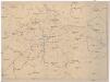
Okolí Prahy

Die Gegend um Prag...
[Isochronická mapa okolí Prahy]
Praha (Česko : oblast) Pohl, J.
Isochronická a isochorická mapa okolí pražského
1 : 400000 Praha (Česko : oblast) Pohl, J.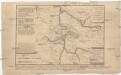
[Obléhání Prahy r. 1757]
1 : 400000 Praha (Česko)
Die Gegend um Prag...
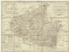
Charte vom Berauner Kreise des Königreichs Böheim
1 : 250000 Beroun-oblast (Česko) Kreibich, František Jakub Jindřich Pluth, Caspar C. W. Enders
Charte vom Berauner Kreise des Königreichs Böheim
1 : 250000 Beroun-oblast (Česko) Kreibich, František Jakub Jindřich Pluth, Caspar C. W. Enders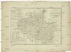
Charte vom Berauner Kreise des Königreichs Böheim
1 : 250000 Beroun-oblast (Česko) Kreibich, František Jakub Jindřich Pluth, Caspar C. W. Enders
Charte vom Berauner Kreise des Königreichs Böheim
1 : 250000 Beroun-oblast (Česko) Kreibich, František Jakub Jindřich Pluth, Caspar C. E. Rainold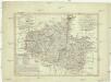
Charte vom Berauner Kreise des Königreichs Böheim
1 : 250000 Beroun-oblast (Česko) Kreibich, František Jakub Jindřich Pluth, Caspar C. E. Rainold
Charte vom Berauner Kreise des Königreichs Böheim
1 : 250000 Beroun-oblast (Česko) Kreibich, František Jakub Jindřich Pluth, Caspar C. E. Rainold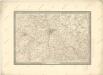
Prozkoumání Čech, sekce V.

Prozkoumání Čech, sekce V.