Maps of Trentino-Alto Adige/Südtirol

Die gefürst. Grafschaft Tirol u. das Land Vorarlberg
Tyrolsko (Rakousko) Ignaz Fuchs
Comitatus Principalis Tirolis in quo Episc. Tridentinus et Brixensis, Comitatus Brigantinus, Feldkirchiae, Sonnebergae et Pludentii
Homann, Johann Baptist Homann
Comitatus Principalis Tirolis in quo Episc. Tridentinus et Brixensis, Comitatus Brigantinus, Feldkirchiae, Sonnebergae et Pludentii
Homann, Johann Baptist Homann
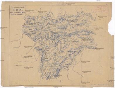
Wandkarte von Tirol und Vorarlberg : für Volks- und Mittelschulen
Kaler, G. v. Wagner
Tyrol, Vorarlberg, Liechtenstein.
1 : 800000 Flemming, Carl

Le Comté Du Tirol l'Eveché de Trente et de Brixen : Suivant les dernieres Observations avec les Routtes et Passages
Le Rouge, Georges-Louis Le Rouge
Principali Dignitate Gaudens Comit[atus] Tirolis Episcopat[us] Tridentinum Et Brixiensem
Seutter, Matthäus Lotter
Handkarte der gefürsteten Grafschaft Tirol mit dem Lande Vorarlberg
1 : 750000 Innsbruck (Rakousko) Schober, Karl k. u. k. milit.-geograph. Institute
Comitatus Principalis Tirolis in quo Episc. Tridentinus et Brixensis, Comitatus Brigantinus, Feldkirchiae, Sonnebergae et Pludentii
Homann, Johann Baptist Homann
[Le Tirol]

Karte der gefürsteten Grafschaft Tyrol nach den vortrefflichen Karten des Peter Anich und Blasius Huber
Tyrolsko (Rakousko) Kipferling, Karl Joseph Anich, Peter im Verlage des Kunst und Industrie Comptoirs
Karte der gefürsteten Grafschaft Tyrol
Tyrolsko (Rakousko) Kipferling, Karl Joseph Anich, Peter im Verlage des Kunst und Industrie Comptoirs
Comitatus Tyrolis tabula
1 : 1040000 Tyrolsko (Rakousko) Granelli, Carlo Engelbrecht, Christian Pfeffel et Engelbrecht
Charte von Tirol und Vorarlberg
1 : 520000 nach den besten Hülfsquellen und neuesten astronomischen Orts-Bestimmungen entworfen von F. W. Streit nach den neuesten äusseren Grenzen berichtiget 1817 Weimar : Verlag des Geograph. Instituts
Karte von der gefürsteten Grafschaft Tyrol
1 Karte : Kupferdruck ; 47 x 56 cm Walch zufinden in Kunst u. Landkarten Verlag des I. Walch
Karte von der gefürsteten Grafschaft Tyrol
1 Karte : Kupferdruck ; 46 x 55 cm Walch zufinden in Kunst u. Landkarten Verlag des I. Walch

Reichsratwahlkarte

Tyrol, Voralberg, Lichtenstein.
1 : 810000 Radefeld, Carl Christian Franz, 1788-1874
Handkarte der Gefürsten Grafshaft Tirol mit dem Lande Vorarlberg

Tirolis comitatus continens episcop. Tridentinum et Brixiensem nec non comit. Brigantinum, Feldkirch Sonneberg et Pludentin. mappa geographica novissime et exactissime exarata
1 : 530000 cura et sumptibus Tobiae Conradi Lotter Aug. Vind : Tobias Conrad Lotter
Die gefuerstete Grafschaft Tyrol nebst Vorarlberg und dem Fürstenthum Liechtenstein
1 : 500000 Innsbruck (Rakousko : oblast) Weiland, Karl Ferdinand im Verlage des Geograph. Instituts
Die gefuerstete Grafschaft Tyrol nebst Vorarlberg und dem Fürstenthum Liechtenstein
1 : 500000 Innsbruck-oblast (Rakousko) Weiland, Karl Ferdinand Mädel im Verlage des Geograph. Instituts
Die gefürstete Grafschaft Tyrol nebst Vorarlberg und dem Fürstenthum Liechtenstein
1 : 500000 Lichtenštejnsko Weiland, Karl Ferdinand Geograph. Institut
Die gefürstete Grafschaft Tirol nebst Vorarlberg, und dem Fürstenthum Lichtenstein
Lichtenštejnsko Marco Berra
Il Tirolo con li Vescovati di Trento e Brixen e la Città Imperiale di Costanza che sono in protezione de Conti del Tirolo, le Contee di Bregentz e Pludentz che sono incorporate allo stesso e li Feudi e Dependenze che li sono soggetti
Cantelli, Giacomo Giacomo de Rossi
Reise-Karte von Tyrol u. Vorarlberg mit den angränzenden Ländertheilen
1 : 600000 Salcburské Alpy (Rakousko) Mayr, Georg Obernetter, Johann Verlag der liter. artistischen Anstalt