Maps of Italy

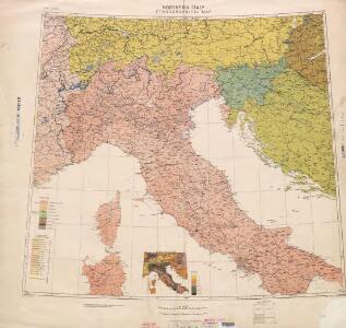
Ethnographical map (Eastern Europe). Northern Italy 1918
1 : 1500000 First World War ethnographical map (Eastern Europe). 1918. Four sheets, covering Germany, Poland, Northern Italy and South eastern Europe. To illustrate the post-WW1 settlement. War Office
Ober und Mittel Italien

Carte d'une partie de l'Italie, pour servir à l'itinéraire d'un voyage fait dans ce pays, par Petit-Radel, en 1811 et 1812
1 : 2500000 [S.l.] : [s.n.]
Ober und Mittel Italien

Illyricum Occidentis
1 : 3000000 Mollova mapová sbírka Sanson, Nicolas Covens, Johannes I
Illyrivcum Occidentis
1 : 1300000 Mollova mapová sbírka Sanson, Nicolas Cordier, Louis
Austria.
from Abraham Ortelius his epitome of the theater of the worlde / nowe latlye ... renewed and augmented ... by Micheal Coignet, mathematitian of Antwarpe.
Italy.
1 : 3380000 Sharpe, J.
Carta postale e stradale dell'Italia
1 : 1050000 Itálie Pinneti, G. A. F. Artaria
Italia Antiqua.
1 : 5000000 Finley, Anthony
Italia antica
1 : 3000000 Marzolla, Benedetto [Verlag nicht ermittelbar]
General Karte von Italien und Dalmatien
1 : 3090000 Dalmácie (Chorvatsko) Brué, A. H. Rothenburg, Rudolf von bey Artaria und Comp.
Italie ancienne.
1 : 3000000 Picquet, C.
[Sexta Europe tabula] [Karte], in: Clavdii Ptholomei Viri Alexandrini Cosmographie, S. 146.
1 Karte aus Atlas Nicolaus Germanus [und Ptolemaeus, Claudius]
L'Italie septentrionale.
1 : 2050000 Rizzi Zannoni, Giovanni Antonio Bartolomeo, 1736-1814
Italie moderne.
1 : 3000000 Brue, Adrien Hubert, 1786-1832
Tabula Moderna Italie. [Karte], in: Claudii Ptolemei viri Alexandrini mathematice discipline philosophi doctissimi geographie opus [...], S. 257.
1 Karte aus Atlas Waldseemüller, Martin [und Ptolemaeus, Claudius] Übelin, Georg
Italie, Suisse, Illyrie nord.
1 : 2100000 Picquet, C.
Italia Antiqua. (1826)
1 : 5000000 Tanner, Henry S.
Strade ferrate e navigazione dell' Italia
1 : 1738000 Itálie L. Ronchi
Carte de l'Italie et des pais circonuoisins
1 : 2490000 Itálie Sanson, Nicolas Magini, Giovanni Antonio par Melchior Tauernier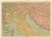
Pohraničí rakousko-uhersko-italské
1 : 1250000 Itálie Machát, František V. Neubert
Italie.
1 : 1500000 Jouvet et Cie.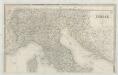
Italia
1 : 1140000 Sacchi, Ferd. Ditta Artaria di Ferd.o Sacchi e figli
Italien.
1 : 4500000 Reichard, C. G.
Composite: Italie, Suisse, Illyrie.
1 : 2100000 Brue, Adrien Hubert, 1786-1832
Carta generale delle Strade Ferrate Italiane

Italie ancienne.
1 : 3000000 Brue, Adrien Hubert, 1786-1832
Sexta Europe Tabula [Karte], in: [Clavdii Ptholomei Cosmographi ...], S. 269.
1 Karte aus Atlas Nicolaus Germanus [und Ptolemaeus, Claudius]