Maps of Cambodia

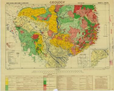
Indo-China and Siam 1:1,000,000, Geology (Sheet 3 - South)
Geology, Indo-China and Siam 1:1,000,000 , Series GSGS 4555A. Great Britain. Inter-service Topographical Dept. [S.l.] : Inter-Service Topographical Department
Carte routière de la Cochinchine et du Cambodge
1 : 1000000 Office local du tourisme au Cambodge Phnom-Penh : Société d'éditions Khmer
Carte forestière du Cambodge
1 : 1000000 Indochine. Inspection générale de l'agriculture, de l'élevage et des forêts [Hanoï ?] : Service géographique de l'Indochine
Saigon
1 : 500000 Indochine. Service géographique [Hanoï] : Service géographique de l'Indochine
Khong
1 : 500000 Indochine. Service géographique [Hanoï] : Service géographique de l'Indochine
Cochinchine physique
Russier, Henri
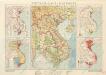
Cochinchine politique
Russier, Henri
Villages du delta cochinchinois
1 : 500000 Indochine. Service géographique
Carte du groupe et du parc d'Angkor : arrêté du 21 mai 1930
1 : 40000 Parmentier, Henri 1871-1949; École française d'Extrême-Orient [Hanoï] : [Ecole française d'Extrême-Orient]
Carte de l'Indochine au 2.000.000e : Carte ethnolinguistique
1 : 2000000 Indochine. Service géographique [Hanoi?] : Service géographique de l'Indochine
Carte économique de l'Indochine
1 : 2480000 Agence économique de l'Indochine [Paris] : Agence économique de l'Indochine
Les missions catholiques dans l'Indo-Chine française
1 : 2000000 Launay, Adrien 1853-1927 [Lyon : Oeuvre de la propagation de la foi]
Carte générale de l'Indochine Française
1 : 2000000 Institut géographique national. France Paris : Institut Géographique National
地圖綜要 : 三卷(安南圖)
地圖綜要 南明弘光元年(1645),吴学俨等编纂,李釜源鉴定,朗润堂藏板。 该书为明末军事防务地图集,涉及诸多江防、海防、边防等相关地图和解说,军事意味明显,这与成书背景有密切关系。该书在江南刊刻成书之际,清军已大举入关,大明王朝覆灭,仅剩南明小王朝残喘于南方,军事防务至关重要。也因其明显的南明立场,该书被列为四库禁毁书。全书分总卷、内卷和外卷三部分。燕京藏本共八册,书前序言、凡例和目录的总卷部分缺失。 总卷论及大明疆域沿革、军事防守要害、各省道里等内容,地图有《華夷古今形勝圖》,未画方,标绘各府所在,在空白处标注史地简介;《天下各鎮各邊要圖》,未画方,标注北方边防各山口关隘、东南海防、西南边防等;《京省合宿分界圖》,未画方,图上方标注各星宿,对应大明各府州;《天下輿地分里總圖》,计里画方,每方五百里,绘制两京十三省各府所在地。 内卷为两京十三省的建置总数、分里图、分界图、各府州县志、总论及事宜,其中,建制总数包括府州县卫所及各类机构数量、户数、口数、税、钞、丝、绢、盐、马草等数量;分里图采用计里画方,分别绘制两京十三省各府、州、县、卫所及山川河流名;分界图则以突出府界和州县的相对位置,并不追求里程的准确性,因此,与分里图相比,不仅删去了山川地名和解说,而且地图变形较大,以便于较为疏朗地标注各府州县地名;各府州县志则包括省内各府的山川河流、土产古迹、名宦人物等通常为方志所记载的内容;总论高度概括各地历史和地理形势;事宜则多论及该地的军事守备要领。每省分里图和分界图各一幅。 外卷主要为江防、海防、边防相关地图和图说。包括《長江會源分里全圖》《江防全圖》《漕河分里圖》《黃河分里圖》《海防全圖》《日本島夷入寇要害圖》《海運分里圖》《九邊總圖》及九边分图《遼東沿邊圖》《薊鎮沿邊圖》《宣府沿邊圖》《大同沿邊圖》《山西沿邊圖》《大同山西二邊分里合圖》《延綏沿邊圖》《寧夏沿邊圖》《固原沿邊圖》《甘肅沿邊圖》《四夷總圖》及四夷分图《東北諸夷圖》《朝鮮圖》《日本圖》《琉球圖》《東南海夷圖》《東南濱海諸夷圖》《西南海夷圖》《安南圖》《迤北西番諸夷圖》《西域圖》《朔漠圖》等。 在外卷诸图中,以《江防全圖》规模最大、绘制最为详细,并附有详细的解说,显然,这与当时南明小王朝偏居南方的局势密切相关,天堑长江实际上已经成为南明小王朝最后的屏障。 在图例上,府用正方形,州用菱形(包括土州),县用椭圆,卫所用椭圆外加四方短线,但图上大多数卫所并没有标志。 李釜源名茹春,崇祯十年(1637 年)进士,知华亭县。 《中國古籍善本書目》著录。 8册64图,墨刻本,中文,尺寸24.7 x 16.3 cm,计里画方。 Harvard-Yenching | Rare Book | T 3080.7 2925,Harvard-Yenching | Microfilm | FC9113, Master Microforms | Offsite Storage | Film Mas 34483;Hollis Number:008094513 吴学俨等 朗润堂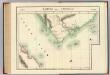
Partie de Camboge. Asie 110.
1 : 1641836 Vandermaelen, Philippe, 1795-1869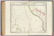
Camboge et Anam. Asie 105.
1 : 1641836 Vandermaelen, Philippe, 1795-1869
Nha Trang
1 : 500000 Indochine. Service géographique [Hanoï] : Service géographique de l'Indochine
Pak Nam
1 : 500000 Indochine. Service géographique [Hanoï] : Service géographique de l'Indochine
Qui Nhon
1 : 500000 Indochine. Service géographique [Hanoï] : Service géographique de l'Indochine
Croquis de la province de Kontum
1 : 200000 [Hanoï] :
Vinh Long
1 : 500000 Indochine. Service géographique [Hanoï] : Service géographique de l'Indochine
Indo-Chine Française
Vidal de La Blache, Paul
Carte populaire : Indo-Chine : Cambodge - Cochinchine - Annam - Tonkin
1 : 5000000 Favre, Georges 1840-1916 Bordeaux :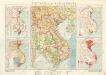
Vietnam, Laos, Kambodža
Vietnam-Laos-Kambodža

Indo-Chine : carte de la mission Pavie / dressée sous les auspices du Ministre des Affaires Étrangères et du Ministre de Colonies sous la dir. de M[onsieur] Pavie par les capitaines Cupet ... [et al.] ; gravé par R. Hausermann
1 : 2000000 Annotatie geografische gegevens: Opname: 1880-1895, herz. en aangevuld 1909, 1913 en 1921 Pavie, Auguste; Cupet, Pierre Paul; Hausermann, R. Paris : Augustin Challamel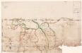
[Zuidoost-Azië] / [J.F. van Essen]
1 : 6650000 Annotatie: Gerestaureerd, 1995 Essen, J. F. van [Antwerpen : J.F. van Essen]
Indochine.
1 : 5000000 Vivien St Martin, L.
Charte von den Reichen Siam und Cochinchina
1 : 6340000 zgest. von John Walker für die Beschreibung von Hn. Crawfurd's Mission Weimar : im Verlage des Geograph. Instituts