Maps of Maldon
Witham
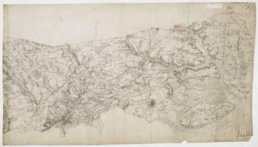
Colchester is the largest settlement featured on this drawing. The draughtsman has recorded the layout of the streets in red ink. On nearby Lexden Heath, an 'Ancient Intrenchment' is depicted. These lines of entrenchment date back to the Roman occupation. The drawing extends to cover Mersey Island and the River Colne. The salt marshes are distinguished by irregular patterning and the individual channels of the Colne are named. A military battery is marked at the mouth of the river, reflecting the military focus of these drawings. A blue line indicates the level of the low water mark.
TL81 - OS 1:25,000 Provisional Series Map
1 : 25000 Topographic maps Ordnance Survey Ordnance Survey
TL91 - OS 1:25,000 Provisional Series Map
1 : 25000 Topographic maps Ordnance Survey Ordnance Survey
TM01 - OS 1:25,000 Provisional Series Map
1 : 25000 Topographic maps Ordnance Survey Ordnance Survey
Essex nXXXVII - OS Six-Inch Map
1 : 10560 Topographic maps Ordnance Survey Ordnance Survey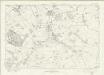
Essex nXLVI - OS Six-Inch Map
1 : 10560 Topographic maps Ordnance Survey Ordnance Survey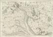
Essex XXXVI - OS Six-Inch Map
1 : 10560 Topographic maps Ordnance Survey Ordnance Survey
Essex XXXV - OS Six-Inch Map
1 : 10560 Topographic maps Ordnance Survey Ordnance Survey
Essex XXVII - OS Six-Inch Map
1 : 10560 Topographic maps Ordnance Survey Ordnance Survey
Essex XXVI - OS Six-Inch Map
1 : 10560 Topographic maps Ordnance Survey Ordnance Survey
TL92 - OS 1:25,000 Provisional Series Map
1 : 25000 Topographic maps Ordnance Survey Ordnance Survey
Essex XXXVII - OS Six-Inch Map
1 : 10560 Topographic maps Ordnance Survey Ordnance Survey
TM02 - OS 1:25,000 Provisional Series Map
1 : 25000 Topographic maps Ordnance Survey Ordnance Survey
TL82 - OS 1:25,000 Provisional Series Map
1 : 25000 Topographic maps Ordnance Survey Ordnance Survey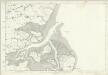
Essex XXVIII - OS Six-Inch Map
1 : 10560 Topographic maps Ordnance Survey Ordnance Survey
Essex XLV - OS Six-Inch Map
1 : 10560 Topographic maps Ordnance Survey Ordnance Survey
Essex XLVI - OS Six-Inch Map
1 : 10560 Topographic maps Ordnance Survey Ordnance Survey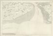
Essex XLVII - OS Six-Inch Map
1 : 10560 Topographic maps Ordnance Survey Ordnance Survey
Essex nXXXV - OS Six-Inch Map
1 : 10560 Topographic maps Ordnance Survey Ordnance Survey
Essex nXLV - OS Six-Inch Map
1 : 10560 Topographic maps Ordnance Survey Ordnance Survey
Essex nXXXVIII - OS Six-Inch Map
1 : 10560 Topographic maps Ordnance Survey Ordnance Survey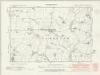
Essex nXXXVIII.NW - OS Six-Inch Map
1 : 10560 Topographic maps Ordnance Survey Ordnance Survey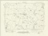
Essex nXXXVIII.NW - OS Six-Inch Map
1 : 10560 Topographic maps Ordnance Survey Ordnance Survey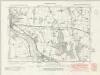
Essex nXXXVIII.SW - OS Six-Inch Map
1 : 10560 Topographic maps Ordnance Survey Ordnance Survey
Essex nXXXVIII.SW - OS Six-Inch Map
1 : 10560 Topographic maps Ordnance Survey Ordnance Survey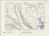
Essex nXLVIII.NW - OS Six-Inch Map
1 : 10560 Topographic maps Ordnance Survey Ordnance Survey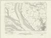
Essex nXLVIII.NW - OS Six-Inch Map
1 : 10560 Topographic maps Ordnance Survey Ordnance Survey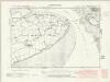
Essex nXLVIII.SW - OS Six-Inch Map
1 : 10560 Topographic maps Ordnance Survey Ordnance Survey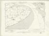
Essex nXLVIII.SW - OS Six-Inch Map
1 : 10560 Topographic maps Ordnance Survey Ordnance Survey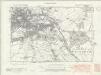
Essex nXXXVII.NE - OS Six-Inch Map
1 : 10560 Topographic maps Ordnance Survey Ordnance Survey