Maps of Monmouthshire

MONUMENTHENSIS Comitatus
This map of Monmouthshire is from the 1583 edition of the Saxton atlas of England and Wales.This atlas was first published as a whole in 1579. It consists of 35 coloured maps depicting the counties of England and Wales. The atlas is of great significance to British cartography as it set a standard of cartographic representation in Britain and the maps remained the basis for English county mapping, with few exceptions, until after 1750. During the reign of Elizabeth I map use became more common, with many government matters referring to increasingly accurate maps with consistent scales and symbols, made possible by advances in surveying techniques. Illustrating the increasing used of maps in government matters, Lord Burghley, Elizabeth I’s Secretary of State, who had been determined to have England and Wales mapped in detail from the 1550s, selected the cartographer Christopher Saxton to produce a detailed and consistent survey of the country. The financier of the project was Thomas Seckford Master of Requests at the Court of Elizabeth I, whose arms appear, along with the royal crest, on each map. Saxton, Christopher Ryther, Augustine
Monumethensis Comitatus. Vernacule Monmouth Shire. [Karte], in: Theatrum orbis terrarum, sive, Atlas novus, Bd. 4, S. 404.
1 Karte aus Atlas Blaeu, Joan Blaeu, Willem Janszoon
Monumethensis Comitatus. Vernacule Monmouth Shire. [Karte], in: Le théâtre du monde, ou, Nouvel atlas contenant les chartes et descriptions de tous les païs de la terre, Bd. 4, S. 350.
1 Karte aus Atlas Blaeu, Willem Janszoon und Blaeu, Joan Blaeu, Willem Janszoon
Monumethensis Comitatus. Vernacule Monmouth Shire. [Karte], in: Theatrum orbis terrarum, sive, Atlas novus, Bd. 4, S. 404.
1 Karte aus Atlas Blaeu, Joan Blaeu, Willem Janszoon
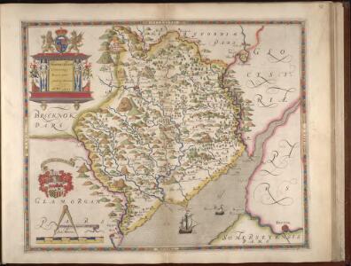
MONVMETHENSIS | COMITATVS. | Vernacule | MONMOVTH SHIRE.
I. Blaeu Exc.

MONUMETHENSIS Comitatus
This is a map of Monmothshire by Christopher Saxton dating from 1577. It forms part of an atlas that belonged to William Cecil Lord Burghley, Elizabeth I’s Secretary of State. Burghley used this atlas to illustrate domestic matters. This map is actually a proof copy of one which forms part of Christopher Saxton’s Atlas of England and Wales. This atlas was first published as a whole in 1579. It consists of 35 coloured maps depicting the counties of England and Wales. The atlas is of great significance to British cartography as it set a standard of cartographic representation in Britain and the maps remained the basis for English county mapping, with few exceptions, until after 1750. During the reign of Elizabeth I, map use became more common, with many government matters referring to increasingly accurate maps, with consistent scales and symbols, made possible by advances in surveying techniques. Illustrating the increasing use of maps in government matters, Lord Burghley, who had been determined to have England and Wales mapped in detail from the 1550s, selected the cartographer Christopher Saxton to produce a detailed and consistent survey of the country. The financier of the project was Thomas Seckford, Master of Requests at the Court of Elizabeth I, whose arms appear, along with the royal crest, on each map. Burghley has annotated this map, adding several place names. The name of the engraver of this map is not included but it would have been one of a team of seven English and Flemish engravers employed to produce the copper plates for the atlas. Saxton, Christopher William Cecil, Lord Burghley
Monvmethensis comitatvs vernacule Monmovth Shire
1 Karte : Kupferdruck ; 37 x 48 cm Blaeu Joan Blaeu
Bristol and Newport - OS One-Inch Map
1 : 63360 Topographic maps Ordnance Survey Ordnance Survey
Abergavenny
1 : 31680 This plan of part of Monmouthshire shows the valley of the River Usk running from top to bottom of the sheet, with the Abergavenny canal (used to carry a small trade up to Breconshire) following the course of the river. To the left of the plan, the Welsh valleys stretch down the coastal plain from the Brecon Beacons to the cities of Cardiff, Swansea and Newport. Rich in iron ore, coal and limestone, the valleys developed from rural to industrial communities during the course of the 18th century. Highlighted in red along the mines and ironworks of the valleys are tramroads, the horse-worked railways predating the age of steam. Budgen, Charles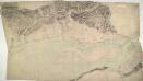
Newport 21
1 : 31680 This drawings depicts the winding course of the River Usk as it flows by the Roman town of Caerleon into the Severn Estuary and the Bristol Channel. Not far from the river mouth lies Newport. The Usk is not navigable except at this point, but the Monmouthshire and Brecon and Abergavenny canals, in part following the valley, carry a small trade up to Brecon. Cardiff, depicted at bottom left, was a town of only 6,000 inhabitants when this plan was produced. Budgen, Charles
Chepstow
1 : 31680 Thomas Budgen surveyed the majority of the Welsh plans, and is probably author of this drawing of the Severn Estuary. The plan is a good example of the use of black and red ink to distinguish between wooden and masonry structures. Chepstow Bridge, on the River Wye, is illustrated with red piers and a black roadway. Budgen, Thomas
Cardiff - OS One-Inch Map
1 : 63360 Topographic maps Ordnance Survey Ordnance Survey
Usk(002OSD000000003U00162000)
1 : 31680 .The Monnow Valley, down the right side of the sheet, forms a natural break in defences along the border of southern Wales.,Depicted along the valley are the Norman,castles of Grosmont, Skenfirth, Tregets and Monmouth, which,once guarded the routes between Herefordshire and Wales. ,Monmouth was of particular importance, lying exactly on the border where the river Monnow joins the Wye. Iron roads, the horse railroads pre-dating the locomotive era, feature at lower right. Highlighted,in ochre, these were probably added,to the plan some time after its official completion. Budgen Charles
Usk(002OSD000000003U00161000)
1 : 31680 .Farmland and rolling hills dominate this plan of the Usk Valley, forming a natural break in defences along the southern Welsh border., In the 11th century, the English Marcher Lords and the Welsh often clashed here over the control of land., The remains of the legionary fort at Usk, one of the main Roman sites in Wales, are depicted in the centre of the drawing. Budgen Charles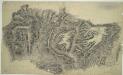
Bedwas
1 : 31680 .Bedwas was one of the first industrial towns in England. The surrounding area is rich in coal, iron ore and limestone deposits. There is evidence that suggests the monks of Neath Abbey,amp; may have been using coal to make iron since AD1284. By the early 19th century, an elaborate network of horse-worked railways ('iron ways') was being built to connect collieries and ironworks. These are indicated on the plan by parallel lines highlighted in yellow ochre. Budgen, Charles
Abergavenny (Outline) - OS One-Inch Revised New Series
1 : 63360 Topographic maps Ordnance Survey Ordnance Survey
Abergavenny (Hills) - OS One-Inch Revised New Series
1 : 63360 Topographic maps Ordnance Survey Ordnance Survey
Newport (Hills) - OS One-Inch Revised New Series
1 : 63360 Topographic maps Ordnance Survey Ordnance Survey
Newport (Outline) - OS One-Inch Revised New Series
1 : 63360 Topographic maps Ordnance Survey Ordnance Survey
Monmouth (Hills) - OS One-Inch Revised New Series
1 : 63360 Topographic maps Ordnance Survey Ordnance Survey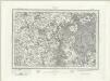
Monmouth (Outline) - OS One-Inch Revised New Series
1 : 63360 Topographic maps Ordnance Survey Ordnance Survey
Chepstow (Hills) - OS One-Inch Revised New Series
1 : 63360 Topographic maps Ordnance Survey Ordnance Survey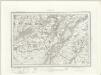
Chepstow (Outline) - OS One-Inch Revised New Series
1 : 63360 Topographic maps Ordnance Survey Ordnance Survey
Brecknock
1 : 31680 .Before railways and modern roads, the Monmouthshire and Brecon Canal was the industrial artery of south Wales. It is shown here starting at Brecknock, at the top of the drawing, and following the mountainside for most of its 33-mile journey to the junction with the Monmouthshire Canal at Pontymoile. Tramways, the horse-worked railways of the pre-locomotive era, are indicated across the Brecon Beacons. Used to carry coal, iron ore and limestone from the mines to the valley's furnaces and ironworks, they are highlighted in yellow ochre on the plan. Budgen, Thomas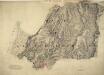
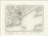
Chipping Sodbury
1 : 31680 The Avon barracks and battery are documented at the mouth of the River Severn, at the top of the map, protecting the Bristol Channel. Gravemounds ('Tumuli'), hill forts, ancient camps and antiquities are distinguished by the use of gothic lettering. The recording of archaeological details became obligatory in 1816. Quarries, kilns, mills, brickyards and pits dominate this industrial region of the West Midlands. According to a note in the Ordnance Survey Day Books, held in the National Archives, a one inch-to-the-mile reduction of this plan was delivered to Captain Gossett for engraving in the Drawing Office at the Tower of London in March 1830. Crocker, Edmund
Llantrisant
This plan covers part of the southern Welsh coast. Field boundaries and woodland are indicated. Shading and soft brushwork interlining ('hachuring') denote relief. The detailed recording of the undulations of the land is a defining feature of Ordnance Survey drawings, revealing the strategic and military impetus behind the scheme. Budgen, Thomas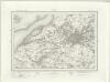
Bristol (Outline) - OS One-Inch Revised New Series
1 : 63360 Topographic maps Ordnance Survey Ordnance Survey
Bristol (Hills) - OS One-Inch Revised New Series
1 : 63360 Topographic maps Ordnance Survey Ordnance Survey
Cardiff (Hills) - OS One-Inch Revised New Series
1 : 63360 Topographic maps Ordnance Survey Ordnance Survey