Maps of Berkshire

Map of Forests around Windsor
Map of the forests around Windsor from "A Description of the Honour of Windesor", John Norden's survey of Windsor. The title page states that the survey was "taken and performed by the perambulation view and delineation of John Norden In Anno 1607". The plans are the result of a survey conducted on foot by Norden. The maps in this volume show communication routes, individual buildings, field boundaries and parkland along with details of wildlife and human activity, such as stags in Windsor Park and people boating on the Thames. The scale at which the maps are presented varies throughout the volume, with feet, perches and miles being the units of measurement recorded by a scale bar. John Norden is best known for his work "Speculum Britainiae", literally a "Mirror of Britain", which in its attempt to include the road names and town plans, lacking on many county maps of the period, was a direct ancestor of the modern A-Z. As well as producing several county maps in the 1590s, Norden worked as a land surveyor producing surveys for landowners and was the author of a work which outlines principles of surveying, known as the "Surveyor's Dialogue". Norden, John
London passenger transport map
Ordnance Survey
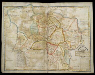
Estates at Windsor, Berkshire
This is a manuscript map of the area surrounding Windsor in Berkshire. It forms part of an atlas that belonged to William Cecil Lord Burghley, Elizabeth I’s Secretary of State. Burghley used this atlas to illustrate domestic matters. Burghley was in charge of administration for the Royal Estate of Windsor. The Royal Estates were notoriously slackly administered, a flaw that no official involved was keen to remedy as there were considerable personal advantages to be gained from inadequacies in the system. The map is drawn to scale with a scale bar of 5.5 - 6 miles. The many parks are shown by enclosure symbols, an important feature of any landscape for military purposes as it was in parks that troops could rest and horses graze. Communication routes such as roads and pathways are indicated by double or single broken lines and the rivers and the points at which they are bridged are also shown. The waterways were a vital communication route at the time, especially in this area where the Thames provides direct access to the centre of London.
England and Wales [OS of]
Ordnance Survey
Odiham
1 : 31680 The most striking feature of this drawing is the triangulation web covering a large area around the East Hampstead Plain. According to manuscript sources, the different ground levels in this region made it an ideal case study for assistant engineers training for the Ordnance Survey under the tuition of Robert Dawson, the surveyor of this plan. Two circles on the main road through Hartford Bridge Flats represent triangulation points. Dawson, Robert
Reading 19
1 : 31680 This drawing has been shaded to give an indication of relative relief. Against this block shading, the network of roads stands out clearly in white. The Thames and its tributaries are turquoise and the draughtsman has indicated the various islands between its banks. In the bottom right, an ink inscription reads: 'This Plan belon[gs to the] Board of Ord[nance] W [Mudge] Col...' Dawson, Robert
A new correct map of Middlesex
Warburton, John, Bland, Joseph and Smyth, Payler
Chobham
1 : 31680 .This map is in poor repair. Its edges are dirty and damaged, and a join is visible where the drawing has been torn. Triangulation points can be seen at the map's boundaries, along with a series of stitch holes. Silk tape was wound through these holes to protect the map in the field. .The drawing details a large number of commons, including Pirbright, Ham Haw and Ockham. These are depicted by patterns of open dotting. Basingstoke Canal also features. It was completed in 1794, only a few years before this map was drawn. Blue washes, used to depict water, have faded. The town of Chertsey appears towards the top right, along with the ruins of Chertsey Abbey. The abbey was founded in AD666, as a house for the Benedictine Order, and dissolved in 1537. Budgen, Thomas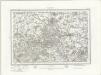
Windsor (Outline) - OS One-Inch Revised New Series
1 : 63360 Topographic maps Ordnance Survey Ordnance Survey
Windsor (Hills) - OS One-Inch Revised New Series
1 : 63360 Topographic maps Ordnance Survey Ordnance Survey
The second sheet of an actual survey of Berkshire
1 Blatt : 68 x 52 cm John Rocque
The first sheet of an actual survey of Berkshire
1 Blatt : 68 x 52 cm publish'd according to act of parliament by John Rocque chorographer to their royal Highnesses the late and present Prince of Wales etc. in the Strand
Aldershot (Hills) - OS One-Inch Revised New Series
1 : 63360 Topographic maps Ordnance Survey Ordnance Survey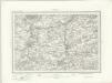
Aldershot (Outline) - OS One-Inch Revised New Series
1 : 63360 Topographic maps Ordnance Survey Ordnance Survey
Carte topographique de le comté de Middlesex, 3
1 Blatt : 53 x 70 cm John Rocque
Uxbridge, Windsor
1 : 31680 This plan of the Chiltern Hills runs from Beaconsfield and Harefield at the top to Windsor Park, Egham and Staines at the bottom. A section of the Grand Junction Canal, running from Harefield down to West Drayton, is shown in aquamarine. The paper carries the watermark "E ,amp; P", standing for Edmeads and Pine. Boyce
The third sheet of an actual survey of Berkshire
1 Blatt : 68 x 52 cm John Rocque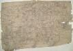
Hampton Court 20
1 : 31680 This drawing of London and the surrounding Thames countryside provides a fascinating blueprint of Regency London. The layouts of the ornamental gardens and tree-lined avenues of Hampton Court and nearby Bushy Park are shown in detail. These contrast with the depiction of Kew Gardens, which is left blank within its boundaries. The Ordnance Survey Letter Book records: "When the Ordnance Survey of the vicinity of Brentford was made, The Surveyor was not permitted to enter Kew Gardens." At that time, King George III was recuperating at Kew from bouts of mental illness: the king's privacy and security took primacy over mapmaking. Stanley, William
Map of Hampshire, including the Isle of Wight, 2
1 Blatt : 55 x 70 cm s.n.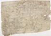
Detail from OSD 127 (Hampton Court), showing Kingston, Richmond and Twickenham
This drawing of London and the surrounding Thames countryside provides a fascinating blueprint of Regency London. The layouts of the ornamental gardens and tree-lined avenues of Hampton Court and nearby Bushy Park are shown in detail. These contrast with the depiction of Kew Gardens, which is left blank within its boundaries. The Ordnance Survey Letter Book records: "When the Ordnance Survey of the vicinity of Brentford was made, The Surveyor was not permitted to enter Kew Gardens." At that time, King George III was recuperating at Kew from bouts of mental illness: the king's privacy and security took primacy over mapmaking. Stanley, William
Reading (Hills) - OS One-Inch Revised New Series
1 : 63360 Topographic maps Ordnance Survey Ordnance Survey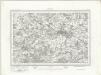
Reading (Outline) - OS One-Inch Revised New Series
1 : 63360 Topographic maps Ordnance Survey Ordnance Survey
Basingstoke (Hills) - OS One-Inch Revised New Series
1 : 63360 Topographic maps Ordnance Survey Ordnance Survey
Basingstoke (Outline) - OS One-Inch Revised New Series
1 : 63360 Topographic maps Ordnance Survey Ordnance Survey
Frogle
1 : 31680 This rough field sketch was drawn on three pieces of paper, subsequently joined and mounted on stiff card. Featuring corrections in black and red ink, it provides a good contrast with more finished drawings. The draughtsman has recorded relief and the layout of the settlements. An avenue of trees near Henwood is represented by individual trees drawn with their shadows falling to the right. "T.P.G" is written on some roads to indicate a turnpike gate.
Carte topographique de le comté de Middlesex, 1
1 Blatt : 53 x 69 cm John Rocque
Detail from OSD 127 (Hampton Court)
This drawing of London and the surrounding Thames countryside provides a fascinating blueprint of Regency London. The layouts of the ornamental gardens and tree-lined avenues of Hampton Court and nearby Bushy Park are shown in detail. These contrast with the depiction of Kew Gardens, which is left blank within its boundaries. The Ordnance Survey Letter Book records: "When the Ordnance Survey of the vicinity of Brentford was made, The Surveyor was not permitted to enter Kew Gardens." At that time, King George III was recuperating at Kew from bouts of mental illness: the king's privacy and security took primacy over mapmaking. Stanley, William
A topographical map, of the county, of Berks, Blatt VIII und XIV
2 Blätter : 99 x 52 cm John Rocque
The Bristol Channel
Two rough plans of the Bristol Channel annotated by Lord Burghley, Secretary of State to Elizabeth I. William Cecil, Lord Burghley