Maps of Northern European Plain

Russiae, Moscoviae Et Tartariae Descriptio. [Karte], in: Theatrum orbis terrarum, S. 292.
1 Karte aus Atlas Ortelius, Abraham
Russiae, Moscoviae Et Tartariae Descriptio. [Karte], in: Theatrum orbis terrarum, S. 107.
1 Karte aus Atlas Ortelius, Abraham
Schema bolševických front

Russiae, Moscoviae Et Tartariae Descriptio. [Karte], in: Theatrum orbis terrarum, S. 387.
1 Karte aus Atlas Ortelius, Abraham Vrients, Jan Baptista
13-14. Soviet Union in Europe. The World Atlas.
1 : 7500000 USSR (Union of Soviet Socialist Republics).
Russia
1 : 40000000 1 Karte : Kupferdruck ; 7 x 11 cm Galle, Philippe [Christophe Plantin]
Russiae Moscoviae et Tartariae descriptio autore Antonio Ienkensono
1 : 48000000 1 Karte : Kupferdruck ; 8 x 11 cm Ortelius, Abraham [Compagnia Bresciana]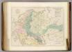
Sketch of the Acquisitions of Russia since the Accession of Peter 1st. to the Throne.
1 : 6969600 Arrowsmith, John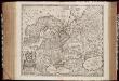
Novissima Russiæ tabula / authore Isaaco Massa
1 : 8500000 Annotatie: Rechtsboven genummerd: VI; Met opdracht van Hondius aan Isaac Bernart; Origineel is Blad 135 in atlas factice; Annotatie geografische gegevens: Met 2 schaalstokken Isaac Abrahamszoon Massa 1586-1643; Henricus Hondius 1573-1650 [Amsterdam, Londen : apud Janssonio-Waesbergios, et Mosem Pitt]
Etnografska karta na slavjanstvoto v Evropa
1 : 5000000 Evropa východní Florinskij, Timofej Dmitrijevič Slavjanska besěda
Europaeisches Russland
Grosser Hand-Atlas über alle Theile der Erde in 170 Karten Meyer, J. Verlag des Bibliographischen Instituts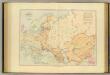
Acquisitions of Russia in Europe, Central Asia.
1 : 9800000 Stanford, Edward
Russia in Asia 1.
1 : 10454400 Letts, Son & Co.
Russia bianca o Moscovia / [Guillaume Sanson] ; Giorgio Widman sculpsit
1 : 7900000 1 Karte : Kupferdruck ; 40 x 54 cm Sanson, Guillaume da Gio. Iacomo Rossi
Russia bianca o Moscovia / [Guillaume Sanson] ; Giorgio Widman sculpsit
1 : 7900000 1 Karte : Kupferdruck ; 40 x 54 cm Sanson, Guillaume da Gio. Iacomo Rossi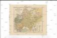
Mapa slovanského světa
1 : 10000000 Evropa Erben, Josef Šafařík, Pavel Josef nákladem Matice lidu
Mapa slovanského světa
Evropa Erben, Josef Šafařík, Pavel Josef nákladem Matice lidu
Mapa slovanského světa
1 : 10000000 Evropa Erben, Josef Šafařík, Pavel Josef nákladem Matice lidu
Mapa slovanského světa
Evropa Erben, Josef Šafařík, Pavel Josef nákladem Matice lidu
Mapa slovanského světa
Evropa Erben, Josef Šafařík, Pavel Josef nákladem Matice lidu
W. Siberia, Tartary, Khiva, Bokhara &c.
1 : 10060000 Society for the Diffusion of Useful Knowledge (Great Britain)
Tabula Asiae VII. [Karte], in: Claud. Ptolemaeus. Geographia lat. cum mappis [...], S. 314.
1 Karte aus Atlas Münster, Sebastian [und Ptolemaeus, Claudius]
Tabula Russiae [...] [Karte] Moscua [Planvedute, [Nebenkarte], in: Novus Atlas, das ist, Weltbeschreibung, Bd. 1, S. 55.
1 Karte aus Atlas Blaeu, Joan Blaeu, Willem Janszoon
Rvssiae, Moscoviae et Tartariae descriptio / auctore Antonio Ienkensono Anglo, edita Londini anno 15
1 : 12000000 1 Karte : Kupferdruck ; 36 x 45 cm Jenkinson, Anthony [Verlag nicht ermittelbar]
Rvssiae, Moscoviae et Tartariae descriptio / auctore Antonio Ienkensono Anglo, edita Londini anno 15
1 : 12000000 1 Karte : Kupferdruck ; 36 x 45 cm Jenkinson, Anthony [Verlag nicht ermittelbar]
A new map of Russia or Moscovie divided into its kingdoms, dukedoms, principalities, provinces etc.
1 Karte : Kupferdruck ; 40 x 53 cm Robert Morden
Russie.
1 : 10000000 Migeon, J.
Europaeisches Russland mit Kasan, Astrachan und Georgien
Schul-Atlas über alle Theile der Erde nach dem neuesten Zustande, und über das Weltgebäude Stieler, Adolf Justus Perthes
Russland
Neuer Handatlas über alle Theile der Erde Kiepert, Heinrich Verlag von Dietrich Reimer
![Russiae, Moscoviae Et Tartariae Descriptio. [Karte], in: Theatrum orbis terrarum, S. 292.](https://images-2.georeferencer.com/images/iiif/979214706487/full/,300/0/native.jpg)

