Maps of Africa

Tabula Quarta Africae. [Karte], in: Claudii Ptolemei viri Alexandrini mathematice discipline philosophi doctissimi geographie opus [...], S. 190.
1 Karte aus Atlas Waldseemüller, Martin [und Ptolemaeus, Claudius] Übelin, Georg
Mapa de África / por José Paluzie Lucena, ingeniero. 1924
1 : 16000000 1 Mapa. Hijo de Paluzie, S. en C. Casa editorial. Diputació 337, Barcelona Paluzie Lucena, José Hijo de Paluzie, S. en C. Casa editorial
Tiré de l'ouvrage les missions catholiques d'Afrique en 1889
1 : 20000000 Bethune, Léon Société de St. Augustin

Africa
Schul-Atlas über alle Theile der Erde nach dem neuesten Zustande, und über das Weltgebäude Stieler, Adolf Justus Perthes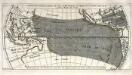
Répresentation du cours ordinaire des vents de traverse qui regnent sur les côtes dans la grande mer du Sud
1 Karte : Kupferdruck ; 15 x 30 cm Cosmant Didot
Afrika
Hand-Atlas über alle Theile der Erde und über das Weltgebäude Stieler, Adolf Justus Perthes
Africa according to the best authorities.
from Carey's general atlas, improved and enlarged : being a collection of maps of the world and quarters, their principal empires, kingdoms, &c.
Africa
1 : 30000000 Calcografia Vignozzi Calcogafia Vignozzi
El Africa dividida en todos sus principales reynos segun las vltimas y nuevas observaciones de las Accademias y de Paris y de Londres
1 Mapa, col. Datació aproximada
Composite: Oceanie.
1 : 15500000 Brue, Adrien Hubert, 1786-1832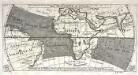
Réprésentation du cours ordinaire des vents de traverse qui regnent le long des côtes dans la mer Atlantique [et] celle des Indes
1 Karte : Kupferdruck ; 15 x 30 cm Cosmant Didot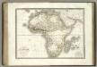
Afrique.
1 : 22000000 Lapie, M. (Pierre), 1779-1850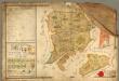
Mappa der zur k.k. Stadt Pilsner gehörigen und von der Hradecker abgetheilte = Bukssitzer
Rukopisná hospodářská mapa lesního revíru Švabiny a Lišky. Oba plány mají stejné měřítko. Značkami a barvou je vyznačen charakter a kvalita porostu. Jsou vyznačeny komunikace, hraniční kameny, 1 malá vodní plocha, 1 usedlo, jména sousedících panství. Vlevo nahoře tabulka s výměrou jednotlivých typů porostů na pozemcích, vlevo dole vysvětlivky značek, vpravo grafické a číselné měřítko v kompozici s neumělou alegorickou postavou.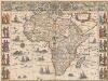
Africae nova descriptio. [Karte], in: Theatrum orbis terrarum, sive, Atlas novus, Bd. 2, S. 288.
1 Karte aus Atlas Blaeu, Joan Blaeu, Willem Janszoon
Afrika
Handatlas über alle Theile der Erde und über das Weltgebäude Stieler, Adolf Justus Perthes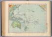
162-63. Oceania fisica.
1 : 30000000 Touring club italiano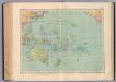
164-65. Oceania politica.
1 : 30000000 Touring club italiano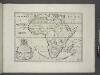
A new map of Africk shewing its present general divisions, chief cities or towns, rivers, mountains &c.
from A new sett of maps both of antient and present geography : wherein not only the latitude and longitude of many places are corrected according to the latest observations, but also the most remarkable differences of antient and present geography may be quickly discern'd by a bare inspection or comparing of correspondent maps, which seems to be the most natural and easy method to lead young students (for whose use the work is principally intended) unto a competent knowledge of the geographical science : together with a geographical treatise particularly adapted to the use and design of these maps / by Edward Wells, M.A. and student of Christ-Church, Oxon.
Afrika
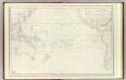
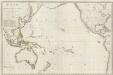
Grand Ocean.
1 : 25000000 France. Depot-general de la Marine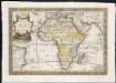
L'Afrique, dressée sur les relations e nouvelles decouvertes de differens voyageurs, conformes aux observations astronomiques
1 : 1
Pacific Ocean. Pergamon World Atlas.
Polish Army Topography Service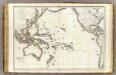
Oceanie.
1 : 29500000 Brue, Adrien Hubert, 1786-1832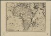
L'Afrique, suivant les nouvelles observations de Mess.rs de l'Académie Royale des Sciences etc., augmentées de nouveau
1 : 41100000 A Leide : chez Pierre vander Aa
Afrika
Stieler's Hand-Atlas Stieler, Adolf bei Justus Perthes
Africae nova descriptio. [Karte], in: Le théâtre du monde, ou, Nouvel atlas contenant les chartes et descriptions de tous les païs de la terre, Bd. 2, S. 281.
1 Karte aus Atlas Blaeu, Willem Janszoon und Blaeu, Joan Blaeu, Willem Janszoon
Pacific Ocean
1 : 35000000 Aleutské ostrovy (Aljaška) National Geographic Society
![Tabula Quarta Africae. [Karte], in: Claudii Ptolemei viri Alexandrini mathematice discipline philosophi doctissimi geographie opus [...], S. 190.](https://images-2.georeferencer.com/images/iiif/999629573247/full/,300/0/native.jpg)

