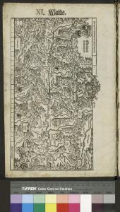
Maps of Valais/Wallis

Landtaflen
1 Atlas [von Johannes Stumpf] Christoffel Froschower, Zürych
<<Der>> Canton Wallis
1 : 450000 1 Karte gez. u. gest. von J. Scheurmann Orell Füssli & Comp., Zürich

Atlas der alten Eidgenossenschaft in 20 Karten: Oberwallis und Unterwallis
Originaltitel: Vallesia superior ac inferior, Wallis. Mit Erklärung der Zeichen und Zeichnungen des Furkagletschers, des Gemmibergs, des Pissevache-Wasserfalls und des grossen St. Bernhards. Zeichnung: Walser, Gabriel (1695-1776), reformierter Pfarrer, von Teufen AR Herausgeber: Homännische Erben
Lombardiae Alpestris pars occidentalis cum Valesia [Karte], in: Gerardi Mercatoris et I. Hondii Newer Atlas, oder, Grosses Weltbuch, Bd. 2, S. 225.
1 Karte aus Atlas Mercator, Gerhard und Hondius, Jodocus Jansson, Jan
Lombardiae Alpestris pars occidentalis cum Valesia [Karte], in: Gerardi Mercatoris Atlas, sive, Cosmographicae meditationes de fabrica mundi et fabricati figura, S. 432.
1 Karte aus Atlas Mercator, Gerhard Montanus, Petrus
Lombardiae alpestris pars occidentalis cum Valesia
1 Karte : Kupferdruck ; 34 x 43 cm Mercator; Hondius Henricus Hondius
Lombardiae alpestris pars occidentalis cum Valesia
1 Karte : Kupferdruck ; 34 x 43 cm Mercator s.n.
[Wallis]
1 : 500000 1 Karte [Johannes Stumpf] [Christoffel Froschouer], [Zürych]
Atlas der Schweiz
1 : 450000 1 Atlas (18 Bl.) gez. u. gest. v. J. Scheurmann Orell Fussli, Zurich
Geologische Kartenskizze der Alpen zwischen St. Gotthard & Montblanc
1 : 350000 Alpy (pohoří) Schmidt, Carl Ernst Finckh
Atlas novus Reipublicae Helveticae
1 Atlas ([40] Bl., 97 S.) bey Orell, Gessner und Compagnie, Zürich
<<Der>> Canton Wallis
1 : 450000 1 Karte gez. u. gest. v. J. Scheuermann Orell Füssli & Comp., Zürich
Taschen-Atlas der Schweiz
1 Atlas (25 S., 20 Taf.) gezeichnet und gestochen von Emil Wagner = Atlas de poche de la Suisse : 26 cartes en couleurs / dessinées et gravées par Émile Wagner Eggimann, Genf
<<Der>> Canton Wallis
1 : 450000 1 Karte gez. u. gest. v. J. Scheuermann Orell Füssli & Comp., Zürich
<<Der>> Canton Bern
1 : 390000 1 Karte gez. u. gest. v. J.J. Scheuermann Orell Füssli & Comp., Zuric [i.e. Zürich]
Parte del Piemonte...

<<Les>> Suisses, leurs alliés et leurs sujets
1 : 230000 1 Karte auf 4 Bl. par Iaillot chez l'auteur joignant les Grands Augustins aux deux Globes, Paris
Nova Helvetiae tabula geographica
1 : 1000000 Südwest-Blatt Scheuchzer, Johann Jakob ; Schenck, Peter ex officina Petri Schenckii
[Südwestschweiz]
1 Karte : Kupferdruck ; 43 x 70 cm s.n.
Karte des Kriegs-Schauplatzes der Schweiz
1 : 700000 2 Karten Verlag der Steiner'schen Buchhandlung, [Winterthur]
Nova Helvetiae tabula geographica illustrissimis et potentissimis cantonibus et rebuspublicis reformatae religionis Tigurinae, Bernensi, Glaronensi, Basiliensi, Scaphusianae, Abbatis Cellanae
1 : 230000 1 Karte auf 4 Bl. dominis suis clementissimis humillime dicata a Ioh. Iacobo Scheuchzero Tigurino ; Ioh. Melch. Füsslin ornamenta pinx. ; Ioh. Henr. Huber et Eman. Schalch sculps. [Hofmeister], [Zürich]
<<Les>> Suisses, leurs alliés et leurs sujets
1 : 230000 1 Karte auf 4 Bl. par A.H. Iaillot, 1703 chez l'auteur joignant les grands Augustins aux deux globes, Paris
Neue Schweizerkarte von 1847
1 : 300000 1 Karte auf 4 Bl. als Wand- und Reliefkarte topisch und politisch dargestellt von Eduard Winckelmann Tobias Dannheimer, Kempten
Postkarte der schweizerischen Eidgenossenschaft
1 : 300000 1 Karte in 4 Teilen unter Aufsicht des General Dufour nach den gegenwürtig vorhandenen Materialien des eidgenössischen Atlasses und den besten Karten gezeichnet von J.R. Stengel u. E. Mohr Wurster, Winterthur
[Reisekarte der Schweiz]
1 : 500000 1 Karte auf 6 Bl. gezeichnet v. H. Keller ; gest. v. J.J. Scheurmann [Füssli & Comp.], [Zürich]
Carte du phénomène erratique et des anciens glaciers du versant nord des Alpes suisses et de la chaîns du Mont-Blanc
1 : 250000 1 Karte auf 4 Blättern par Alphonse Favre ; publ. par la Commission géologique de la Société Helvétique des Sciences Naturelles [Verlag nicht ermittelbar], [Erscheinungsort nicht ermittelbar]
Hypsometrische Karte der Schweiz
1 : 380000 1 Karte auf 4 Blättern von J.M. Ziegler = Carte hypsométrique de la Suisse / par J.M. Ziegler Verlag von Joh. Wurster u. Comp., Winterthur
Karte der Schweiz in IV Blättern
1 : 250000 4 Karten nach dem topographischen Atlasse des eidgenössischen Generalstabes reduziert unter der Direction des Herrn Generals G.H. Dufour ; gest. von H. Müllhaupt Eidg. Stabsbureau, [Bern]