Maps of Baltic Plains

Livoniae Nova Descriptio [Karte], in: Theatrum orbis terrarum, S. 375.
1 Karte aus Atlas Ortelius, Abraham Vrients, Jan Baptista
Livoniae Nova Descriptio [Karte], in: Theatrum orbis terrarum, S. 280.
1 Karte aus Atlas Ortelius, Abraham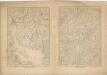
Kriegs Atlas 36 Karten von den Schauplätzen des Weltkrieges 1914/1915

Livonia, Vulgo Lueftland. [Karte], in: Novus Atlas, das ist, Weltbeschreibung, Bd. 1, S. 52.
1 Karte aus Atlas Blaeu, Joan Blaeu, Willem Janszoon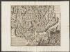
Livonia, Vulgo Lyefland. [Karte], in: Theatrum orbis terrarum, sive, Atlas novus, Bd. 1, S. 64.
1 Karte aus Atlas Blaeu, Joan Blaeu, Willem Janszoon
Neue militairische Situations- und Postkarte von West-Russland
1 : 1320000 Rusko západní Knittel, J. E. Fréderic Campe
Livonia, Vulgo Lyeftland. [Karte], in: Le théâtre du monde, ou, Nouvel atlas contenant les chartes et descriptions de tous les païs de la terre, Bd. 1, S. 64.
1 Karte aus Atlas Blaeu, Willem Janszoon und Blaeu, Joan Blaeu, Willem Janszoon
Reliefkarte der Ostsee von Danzig bis Petersburg
Gdaňsk-oblast (Polsko) Franckh'sche Verlagshandlung
Baltic States & East Prussia.
1 : 2000000 John Bartholomew and Son
Pascaart Vande Oost-Zeeertoonende in sich, alle gelegentheden van Custen van Denemarcken, Sweden, Pomeren, Pruyssen, Courlant. Lyflant en Finlant [...] [Karte], in: Het vijfde Deel Des Grooten Atlas : Vervatende De Water-Weereld, S. 134.
1 Karte aus Atlas Jansson, Jan Jansson, Jan
K vojně so Švecīej 1808 - 1809 gg.
Schweden Seeschlacht Russisch-Schwedischer Krieg <1808-1809>
Livonia [Karte], in: Atlas, sive, Cosmographicae meditationes de fabrica mundi et fabricati figura, S. 150.
1 Karte aus Atlas Mercator, Gerhard
Partie, Russie. Europe 9.
1 : 1641836 Vandermaelen, Philippe, 1795-1869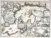
Accurate geographische Vorstellung der Ost-See
1 Karte : Kupferdruck ; 41 x 58 cm Riegel verlegt beÿ Christoph Riegel Buch- und Kunsthändlern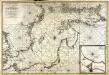
Nieuwe caart van de Oost Zee
1 Karte : Kupferdruck ; 58 x 85 cm chez Jean Cóvens et Corneille Mortier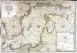
Carte de la mer Baltique
1 Karte : Kupferdruck ; 60 x 88 cm Jaillot; Loon s.n.
Pas-caart van de Oost Zee
1 Karte : Kupferdruck ; 43 x 55 cm Doncker by Hendrick Doncker boekverkoper en graadbooghmaker inde Nieuwbrug-steegh in 't Stuurmans gereedtschap
Carte réduite de la mer Baltique, 2
1 Blatt : 73 x 60 cm Froullé
LIVONIA, | Vulgo | Lyefland.
[Amsterdam : Joan Blaeu]
[Nordwestrussland [12.-15. Jh.]]
Russland Russland (Nord)
Pascaart vande Oost-Zee [...] Tabula Hydrographica Baltici [...] [Karte], in: Novus atlas absolutissimus, Bd. 9, S. 179.
1 Karte aus Atlas Janssonius Offizin

Livonia [Karte], in: Gerardi Mercatoris Atlas, sive, Cosmographicae meditationes de fabrica mundi et fabricati figura, S. 155.
1 Karte aus Atlas Mercator, Gerhard Montanus, Petrus
Nova Totius Livoniae accurata Descriptio. [Karte], in: Gerardi Mercatoris et I. Hondii Newer Atlas, oder, Grosses Weltbuch, Bd. 1, S. 121.
1 Karte aus Atlas Mercator, Gerhard und Hondius, Jodocus Jansson, Jan
Nova Totius Livoniae accurata Descriptio. [Karte], in: Novus atlas absolutissimus, Bd. 1, S. 67.
1 Karte aus Atlas Janssonius Offizin
Feuille 18 (D III), uit: Carte géologique internationale de l'Europe : la carte, votée au congrès géologique international de Bologne en 1881, est exécutée conformément aux décisions d'une commission internationale, avec le concours des gouvernements, sous le dir. de M.M. Beyrich et Hauchecorne
Annotatie: Blad 48 gamme des couleurs; blad 49: bladwijzer en titelblad Heinrich Ernst Beyrich 1815-1896; Wi. Hauchecorne Berlin : Reimer / (Berlin: Institut lithographique)

Russia 3.
1 : 1900800 Letts, Son & Co.
Russland
1 : 3360000 Estonsko Renner Kleinknecht
![Livoniae Nova Descriptio [Karte], in: Theatrum orbis terrarum, S. 375.](https://images-2.georeferencer.com/images/iiif/578547897230/full/,300/0/native.jpg)

