Maps of Charente-Maritime

La Saintonge vers le Midy: Avecq Le Brouageais, Terre d'Arvert &c. [Karte], in: Novus atlas absolutissimus, Bd. 4, S. 150.
1 Karte aus Atlas Janssonius Offizin
La Saintonge vers le midy auecq le Brovageais, terre d'Arvert [et]c
1 Karte : Kupferdruck ; 43 x 55 cm Valck; Sanson; Schenk apud G. Valk et P. Schenk

La Saintonge vers le midy auecq le Brovageais, terre d'Arvert [et]c
1 Karte : Kupferdruck ; 43 x 55 cm Janssonius; Sanson Joannes Janssonius

Dept. De La Charente Infre.
1 : 566000 Levasseur, Victor.
Département de la Charente inférieure
1 Karte : Kupferdruck ; 56 x 49 cm Houdan au bureau de l'atlas national rue de la Harpe n.o 26
La Saintonge vers le midy auecq le Brovageais, terre d'Arvert &c
1 : 260000 Sanson, Guillaume Schenk, Pieter G. Valk, et P. Schenk

Xaintonge et Angoumots. [Karte], in: Novus Atlas, das ist, Weltbeschreibung, Bd. 2, S. 130.
1 Karte aus Atlas Blaeu, Joan Blaeu, Willem Janszoon
Xaintonge et Angoumois. [Karte], in: Theatrum orbis terrarum, sive, Atlas novus, Bd. 2, S. 119.
1 Karte aus Atlas Blaeu, Joan Blaeu, Willem Janszoon
XAINTONGE, | avec | LE PAYS D'AVLNIS, | LE BROVAGEAIS, | TERRE D'ARVERT, | &c.
[Amsterdam : Joan Blaeu]
Xaintonge et Angoumois. [Karte], in: Le théâtre du monde, ou, Nouvel atlas contenant les chartes et descriptions de tous les païs de la terre, Bd. 2, S. 131.
1 Karte aus Atlas Blaeu, Willem Janszoon und Blaeu, Joan Blaeu, Willem Janszoon
Carte des isles de Ré et d'Olleron
1 Karte : Kupferdruck ; 70 x 55 cm Bellin s.n.
Carte dv pais de Xaintonge
1 : 300000 Schenk, Pieter venundantur per Gerardum Valk, et Petrum Schenk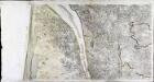
[Côte de Médoc]
2 Blätter : zus. 56 x 111 cm Aldring s.n.
Carte dv pais de Xaintonge
1 Karte : Kupferdruck ; 35 x 48 cm Valck; Schenk venundantur per Gerardum Valk et Petrum Schenk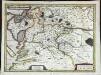
Carte dv pais de Xaintonge
1 Karte : Kupferdruck ; 35 x 48 cm Mercator; Hondius; Hondius excusum apud Iudocum et Henricum Hondium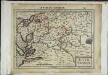
Xaintonge
1 Karte : Kupferdruck ; 17 x 24 cm Mercator; Keere Cloppenburgh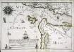
Parties des capitaineries garde costes de Brouage et Bourdeaux
1 Karte : 22 x 33 cm de Fer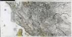
[Ile d'Oléron]
2 Blätter : zus. 57 x 112 cm s.n.
103 Blaye.
1 : 86400 Cassini family; Cassini, Cesar-Francois, 1714-1784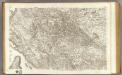
102 Saintes.
1 : 86400 Cassini family; Cassini, Cesar-Francois, 1714-1784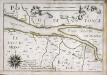
Parties des capitaineries garde costes de Brouage et Bourdeaux
1 Karte : 22 x 33 cm de Fer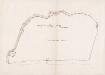
Plan de la ville St. Maixant
[S.l. : s.n.]
Gowernement de Xaintes
1 Karte : Kupferdruck ; 11 x 15 cm Sebastian Cramoisy
Gowerneme[n]ts de Blaye [et] Bourg
1 Karte : Kupferdruck ; 11 x 15 cm Sebastian Cramoisy
Gowernement de La Rochelle
1 Karte : Kupferdruck ; 11 x 15 cm Sebastian Cramoisy
Carte de la coste de la Rochelle a Brouaige et de l'Isle d'Oleron
1 : 81000 Bretaň (Francie) Chattillon Melchior Tauernier
![La Saintonge vers le Midy: Avecq Le Brouageais, Terre d'Arvert &c. [Karte], in: Novus atlas absolutissimus, Bd. 4, S. 150.](https://images-2.georeferencer.com/images/iiif/199645996809/full/,300/0/native.jpg)

