Maps of powiat górowski

Ducatus Silesiae Wolanus [Karte], in: Novus atlas absolutissimus, Bd. 2, S. 261.
1 Karte aus Atlas Janssonius Offizin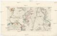
Plan der Bataille zwischen Lissa und Neumarck ohnweit Breslau, da die königl. preuss. Armee die kayserl. königl. Armee den 5 Dec. 1757. angegriffen, und nach einem scharfen Gefechte aus dem Felde geschlagen
Vratislav-oblast (Polsko)
Ducatus | SILESIÆ | WOLANVS
Authore Jona Sculteto | Sprotta Silesio. Amstelædami | J. Blaeu excudebat

Ducatus Silesiae Wolanus
1 : 170000 Mollova mapová sbírka Scultetus, Johannes Schenk, Peter I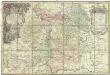
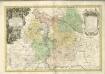
Principatvs Silesiae Wolani in suos circulos, Wohlav, Wintzig, Herrnstadt, Rützen, Steinav und Ravden divisi
1 : 100000 Slezsko Wieland, Johann Wolfgang Schubarth, Matthäus Homannianos Heredes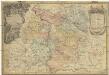
Principatvs Silesiae Wolani in suos circulos, Wohlav, Wintzig, Herrnstadt, Rützen, Steinav und Ravden divisi
1 : 100000 Slezsko Wieland, Johann Wolfgang Schubarth, Matthäus ab Hered. Homan[n]ianis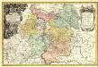
Principatvs Silesiae Wolani in suos Circulos, Wohlav, Wintzig, Herrnstadt, Rützen, Steinav und Ravden divisi
1 : 930000 Mollova mapová sbírka Wieland, Johann Wolfgang Homann, Johann Baptista - dědici
Das Fürstenthum Wohlau in Nieder-Schlesien
1 : 980000 Dolní Slezsko Schleuen, Johann David Schleuen
Plan de la bataille, gagnée par Sa Majesté le roi de Prusse, sur l'armée autrichienne, aux ordres de S. A. R. le duc Charles de Lorraine, prés de Leuthen, ou Lissa, en Silesie, le 5 decembre 1757
Lutynia (Polsko) Schley, Jacobus van der Hondt, Pierre de Pierre de Hondt
106. Lissa, uit: Topographische Uebersichtskarte des Deutschen Reiches / herausgegeben v. d. Kartogr. Abt. d. Königl. Preuß. Landesaufnahme
1 : 200000 titelvariant: Topogr. Übersichtskarte des Deutschen Reiches; Annotatie: Titel boven bladen ook: Topogr. Übersichtskarte des Deutschen Reiches; Annotatie geografische gegevens: Op elk blad twee maatstokken: 10 Kilometer = 5,5 cm; 1 geogr. Meile = 3,6 cm; Legenda onder op elk blad Königlich Preußische Landesaufnahme. Kartographische Abtheilung [S.l : Königlich Preußische Landesaufnahme, Kartographische Abtheilung]
119. Breslau, uit: Topographische Uebersichtskarte des Deutschen Reiches / herausgegeben v. d. Kartogr. Abt. d. Königl. Preuß. Landesaufnahme
1 : 200000 titelvariant: Topogr. Übersichtskarte des Deutschen Reiches; Annotatie: Titel boven bladen ook: Topogr. Übersichtskarte des Deutschen Reiches; Annotatie geografische gegevens: Op elk blad twee maatstokken: 10 Kilometer = 5,5 cm; 1 geogr. Meile = 3,6 cm; Legenda onder op elk blad Königlich Preußische Landesaufnahme. Kartographische Abtheilung [S.l : Königlich Preußische Landesaufnahme, Kartographische Abtheilung]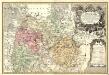
Principatvs Silesiae in suos circulos, tres nempe Lignicenses Goldbergensem, Haynavviensem et Lvbenensem divisii
1 : 100000 Mollova mapová sbírka Wieland, Johann Wolfgang Homann, Johann Baptista - dědici
Special-Carte des Fürstenthums Liegnitz in Nieder-Schlesien
Lehnice-oblast (Polsko) Wieland, Johann Wolfgang Schleuen, Johann David Schleuen
Ducatus Silesiae Ligniciensis
1 : 170000 Mollova mapová sbírka Aveele, Johannes van den Schenk, Peter I
Dvcatvs Silesiae Ligniciensis
1 : 160000 Mollova mapová sbírka Scultetus, Johannes Blaeu, Joan I.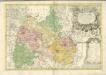

Das Fürstenthum Wohlau in Nieder-Schlesien
1 : 240000 Mollova mapová sbírka Schleuen, Johann David Schleuen, Johann David
Plan der Bataille von Leuthen ohnweit Lissa in Schlesien zwischen der Kayserl. Königl. und Königl. Preusischen Armee den 5. Dec. 1757 vorgefallen
1 : 50000 Back, Jakob Conrad; Brönner, Heinrich Ludwig zu finden bey H. L. Brönner auf dem Pfareyssen
Special-Carte des Fürstenthums Liegnitz in Nieder Schlesien
1 : 230000 Mollova mapová sbírka Schleuen, Johann David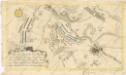
Plan der Bataille bey Breslau...

Die Schlacht an der Katzbach den 26 ten August 1813
1 : 11000 Kaczawa (Polsko) Rahden, Wilhelm von Brose, Heinrich von Prétre
Delineationem Liberae in Silesia Dynastiae Drachenberg
1 : 72900 Mollova mapová sbírka Schenk, Pieter Schenk, Peter I
Meßtischblatt 2827 : Deutsch Lissa, 1934
1 : 250000 Deutsch Lissa. - Hrsg. 1887, bericht. 1926, Nachtr. 1934. - 1:25000. - [Berlin]: Reichsamt für Landesaufnahme, 1934. - 1 Kt.
Meßtischblatt 2827: Lissa, 1887
1 : 250000 Lissa. - Aufn. 1885. - 1:25000. - [Berlin]: Reichsamt für Landesaufnahme, 1887. - 1 Kt.
Meßtischblatt 2825 : Neumarkt i. Niederschlesien, 1932
1 : 250000 Neumarkt i. Niederschlesien. - Hrsg. 1889, bericht. 1927, einz. Nachtr. 1932. - 1:25000. - [Berlin]: Reichsamt für Landesaufnahme, 1932. - 1 Kt.
Meßtischblatt 2825 : Neumarkt (In Schlesien), 1889
1 : 250000 Neumarkt (In Schlesien). - Aufn. 1887. - 1:25000. - [Berlin]: Reichsamt für Landesaufnahme, 1889. - 1 Kt.
Meßtischblatt 2824 : Gr. Tinz, 1936
1 : 250000 Gr. Tinz. - Hrsg. 1889, bericht. 1932, einz. Nachtr. 1936. - 1:25000. - [Berlin]: Reichsamt für Landesaufnahme, 1936. - 1 Kt.
Meßtischblatt 2822 : Kroitsch, 1937
1 : 250000 Kroitsch. - Hrsg. 1887, bericht. 1933, einz. Nachtr. 1936, mehrfarb. Ausg. 1937. - 1:25000. - [Berlin]: Reichsamt für Landesaufnahme, 1937. - 1 Kt.
![Ducatus Silesiae Wolanus [Karte], in: Novus atlas absolutissimus, Bd. 2, S. 261.](https://images-2.georeferencer.com/images/iiif/007811943513/full/,300/0/native.jpg)

