Maps of Landkreis Friesland
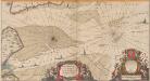
Nobilis Saxoniae Fl. Visurgis, cum Terris adjacentib. Ab Inclyta Brema, ad ostium maris. [Karte, Teil 2], in: Novus atlas absolutissimus, Bd. 2, S. 100.
1 Karte aus Atlas Janssonius Offizin
38. Wilhelmshaven, uit: Topographische Uebersichtskarte des Deutschen Reiches / herausgegeben v. d. Kartogr. Abt. d. Königl. Preuß. Landesaufnahme
1 : 200000 titelvariant: Topogr. Übersichtskarte des Deutschen Reiches; Annotatie: Titel boven bladen ook: Topogr. Übersichtskarte des Deutschen Reiches; Annotatie geografische gegevens: Op elk blad twee maatstokken: 10 Kilometer = 5,5 cm; 1 geogr. Meile = 3,6 cm; Legenda onder op elk blad Königlich Preußische Landesaufnahme. Kartographische Abtheilung [S.l : Königlich Preußische Landesaufnahme, Kartographische Abtheilung]
142. Wilhelmshaven. (Germany)
1 : 100000 Reichsamt fur Landesaufnahme
Composite: 142. Wilhelmshaven. (Germany)
1 : 100000 Reichsamt fur Landesaufnahme
Composite: 109. Wangeroog. (Germany)
1 : 100000 Reichsamt fur Landesaufnahme
109. Wangeroog. (Germany)
1 : 100000 Reichsamt fur Landesaufnahme
Nordsee
1 : 50000 Cuxhaven (Německo) Reichs-Marine-Amt
Composite: 79a. Helgoland. (Germany)
1 : 100000 Reichsamt fur Landesaufnahme
Meßtischblatt Stollhamm
1 : 250000 Stollhamm. - Aufn. 1891, hrsg. 1892, Auflagedr. 1917. - 1:25000. - [Berlin]: Reichsamt für Landesaufnahme, 1917. - 1 Kt.
Meßtischblatt 1019 : Eckwarden, 1892
1 : 250000 Eckwarden. - Aufn. 1891. - 1:25000. - [Berlin]: Reichsamt für Landesaufnahme, 1892. - 1 Kt.
Meßtischblatt 1017 : Jever, 1893
1 : 250000 Jever. - Aufn. 1891. - 1:25000. - [Berlin]: Reichsamt für Landesaufnahme, 1893. - 1 Kt.
Meßtischblatt 1018 : Wilhelmshaven, 1935
1 : 250000 Wilhelmshaven. - Hrsg. 1892, bericht. 1917, einz. Nachtr. 1929. - 1:25000. - [Berlin]: Reichsamt für Landesaufnahme, 1935. - 1 Kt.
Meßtischblatt 1018 : Wilhelmshaven, 1917
1 : 250000 Wilhelmshaven. - Aufn. 1891, hrsg. 1892. - 1:25000. - [Berlin]: Reichsamt für Landesaufnahme, 1917. - 1 Kt.
Meßtischblatt 924 : Schmarren, 1917
1 : 250000 Schmarren. - Aufn. 1891, hrsg. 1892. - 1:25000. - [Berlin]: Reichsamt für Landesaufnahme, 1917. - 1 Kt.
Meßtischblatt 923 : Langwarden, 1892
1 : 250000 Langwarden. - Aufn. 1891. - 1:25000. - [Berlin]: Reichsamt für Landesaufnahme, 1892. - 1 Kt.
Meßtischblatt 921 : Hohenkirchen, 1893
1 : 250000 Hohenkirchen. - Aufn. 1891. - 1:25000. - [Berlin]: Reichsamt für Landesaufnahme, 1893. - 1 Kt.
Meßtischblatt 826/922 : Hooksiel, 1893
1 : 250000 Hooksiel. - Aufn. 1891. - 1:25000. - [Berlin]: Reichsamt für Landesaufnahme, 1893. - 1 Kt.
Meßtischblatt 2213 : Wangerooge, 1940
1 : 250000 Wangerooge. - berichtigt 1938, Ausg. 1940. - 1:25000. - [Berlin]: Reichsamt für Landesaufnahme, 1940. - 1 Kt.
Meßtischblatt 825 : Wangerooge, 1917
1 : 250000 Wangerooge. - Aufn. 1891, hrsg. 1892, Auflagendr. 1917. - 1:25000. - [Berlin]: Reichsamt für Landesaufnahme, 1917. - 1 Kt.
Meßtischblatt 488a, neue Nr. 1813 : Helgoland, 1892
1 : 250000 Helgoland. - Aufn. 1882, hrsg. 1892. - 1:25000. - [Berlin]: Reichsamt für Landesaufnahme, 1892. - 1 Kt.
Germany [Town plans of], Wilhelmshaven
Town plans of Germany, GSGS 4480. Great Britain. War Office. [London] : War Office
[top] HELGELANDIA | Ao. 1649; [bottom] HELGELANDT | in annis Christi 800. | 1300 & 1649.
Matthias Vnd Clauss Petersen | G.S. gebr. Husumenss. sculps. [Amsterdam : Joan Blaeu]
Charte von der Insel Helgoland vor der Elbe mündung in der Nordsee gelegen
Helgoland (Německo)
[Helgoland]
Helgoland (Německo)
Meßtischblatt 920 : Karolinensiel, 1893
1 : 250000 Karolinensiel. - Aufn. 1891. - 1:25000. - [Berlin]: Reichsamt für Landesaufnahme, 1893. - 1 Kt.
Meßtischblatt 824 : Spiekeroog, 1918
1 : 250000 Spiekeroog. - Aufn. 1891, hrsg. 1892, Auflagendr. 1918. - 1:25000. - [Berlin]: Reichsamt für Landesaufnahme, 1918. - 1 Kt.
79a. Helgoland. (Germany)
1 : 100000 Reichsamt fur Landesaufnahme
Meßtischblatt 1111 : Jadebusen, 1900
1 : 250000 Jadebusen. - Aufn. 1898, hrsg. 1900. - 1:25000. - [Berlin]: Reichsamt für Landesaufnahme, 1900. - 1 Kt.
Meßtischblatt 1110 : Steinhausen, 1900
1 : 250000 Steinhausen. - Aufn. 1898. - 1:25000. - [Berlin]: Reichsamt für Landesaufnahme, 1900. - 1 Kt.
![Nobilis Saxoniae Fl. Visurgis, cum Terris adjacentib. Ab Inclyta Brema, ad ostium maris. [Karte, Teil 2], in: Novus atlas absolutissimus, Bd. 2, S. 100.](https://images-2.georeferencer.com/images/iiif/049991719109/full/,300/0/native.jpg)

