Maps of Brandenburg

Marchia Media; Vulgo Mittel Marck in March: Brandenb: [Karte], in: Novus atlas absolutissimus, Bd. 2, S. 60.
1 Karte aus Atlas Janssonius Offizin
Preussische Provinz Brandenburg
1 : 540000 Berlín-oblast (Německo) Gräf, Adolf Biedermann, E. Geographisches Institut
Electoratus sive marchia Brandenburgensis
1 : 1500000 accuratae aeri incisa opera et sumptibus Matthaei Seutteri Albrecht Carl Seutter delin. et sculps. August. Vind : [M. Seutter]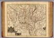
Brandenburg.
1 : 540000 Gundling, Jacob Paul, Freiherr von
Carte de l'Electorat de Brandebourg presentée très humblement à Son Altesse Rojale Monsgr. le Prince Fréderic Guillaume, Prince de Prusse & Marggrave de Brandebourg
1 : 600000 Mollova mapová sbírka Güssefeld, Franz L. Dorn, Sebastian Homann, Johann Baptista - dědici
Electoratus sive marchia Brandenburgensis, juxta novissimam delineationem in mappa geographica, accuratae aeri incisa
1 : 500000 opera et sumptibus Matthaei Seutteri [...] August. Vind. August. Vind. : Matthaeus Seutterus
Berlin Varta Wegweiser

Kreise der Provinz Brandenburg 1864
Preußen, Provinz Brandenburg, Verwaltungsgliederung Kunz, Andreas ; Moeschl, Joachim Robert
Provinz Brandenburg
Grosser Hand-Atlas über alle Theile der Erde in 170 Karten Meyer, J. Verlag des Bibliographischen Instituts
Brandenburg.
1 : 1900000 Flemming, Carl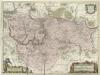
March. Brandenburgici Pars, quae Marchia Media Vulgo Mittesmarck audit
1 : 400000 Mollova mapová sbírka Wit, Frederik de Covens, Johannes I
Marchia Media Vulgo Mittel Marck in March: Brandenb:
1 : 500000 Mollova mapová sbírka Valk, Gerhard Schenk, Peter I
Marchia Media Vulgo Mittel Marck in March: Brandenb:
1 : 510000 Mollova mapová sbírka Janssonius, Johannes Janssonius, Johannes I
Brandenburg, W. Pomerania.
1 : 660000 Robert Laurie & James Whittle
Electoratus sive Marchia Brandenburgensis, juxta novissimam Delineationem in mappa Geographica accuratae aeri incisa opera et Sumptibus
1 : 500000 Mollova mapová sbírka Seutter, Matthäus Seutter, Matthäus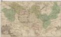
Land-Charte des Chvrfürstenthums Brandenburg
1 : 500000 Braniborsko (Německo) Gundling, Jakob Paul von Busch, Georg Paul G.P. Busch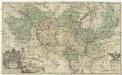
Land-Charte des Chvrfürstenthums Brandenburg
1 : 396000 Braniborsko (Německo) Gundling, Jakob Paul von Busch, G. P. G. P. Busch
Electoratus sive marchia Brandenburgensis juxta novissimam delineationem in mappa geographica, accurate aeri incisa
1 : 548000 Braniborsko (Německo) Seutter, Matthäus sumptibus Mathaei Seutteri
Electoratus sive marchia Brandenburgensis juxta novissimam delineationem in mappa geographica accurate aeri incisa
1 : 548000 Braniborsko (Německo) Seutter, Matthäus Mathaei Seutteri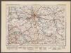
Berlin
1 : 600000 Opitz, Carl Solbrig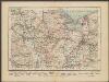
Stettin
1 : 600000 Opitz, Carl Solbrig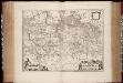
March. Brandenburgici pars, quae Marchia Media vulgo Mittelmarck audit
1 : 400000 Annotatie: Origineel is Blad 91 in atlas factice; Annotatie geografische gegevens: Met schaalstok: Milliaria Germanica Joan Blaeu 1597/98-1673 Amstelaedami : excud. Joannes Blaeu
MARCH. BRANDENBURGICI | PARS, quæ | MARCHIA MEDIA | Vulgo MITTELMARCK audit.
Amstelædami, | Excud. Joannes Blaeu.
[Berlin und Umgebung; Die Donau von Paussau bis Wien mit Umgebung]
Stieler's Hand-Atlas Stieler, Adolf bei Justus Perthes
MARCHIONATUS | BRANDENBURGICI | PARTES DUÆ, | NOVA MARCHIA | et | UCKERANA
Auctore | OLAO JOANNIS GOTHO | Gustaui Magni Cosmographo. [Amsterdam : Joan Blaeu]
[Operationen der alliirten und französischen Armee 1759]

Berlin - Leipzig - Wittenberge

Theatrum belli in Pomerania Citeriori
1 : 140000 Mollova mapová sbírka
Ruppin 47, uit: Special-Karte von Mittel-Europa / nach amtlichen Quellen bearbeitet von W. Liebenow
1 : 300000 titelvariant: W. Liebenow's Mittel-Europa; Annotatie: Titel boven de bladen: W. Liebenow's Mittel-Europa Johannes Wilhelm Liebenow 1822-1897 Frankfurt a. M. : Ludwig Ravenstein
![Marchia Media; Vulgo Mittel Marck in March: Brandenb: [Karte], in: Novus atlas absolutissimus, Bd. 2, S. 60.](https://images-2.georeferencer.com/images/iiif/869040120231/full/,300/0/native.jpg)

