Maps of Sluis
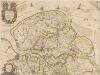
't Meerderdeel van 't Oost-vrye in Vlaenderen [...] [Karte], in: Novus atlas absolutissimus, Bd. 3, S. 124.
1 Karte aus Atlas Janssonius Offizin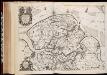
't Meerderdeel van 't Oost-Vrye van Vlaanderen : vertonende d'oprechte gelegenth: der landen, fortressen, schansen ende de nieuw bedijckte polders 't sedert den jare 1648 / [Nicolaes Visscher]
1 : 40000 Annotatie: Origineel is Blad 43 in atlas factice Visscher, Nicolaes (1618-1679) 't Amsteldam : gedruckt by Nicolaes Visscher
't Meerderdeel Van 't Oost-Vrye in Vlaenderen :
1 : 40000 Mollova mapová sbírka Mogge, Jacob Ottens, Aaltje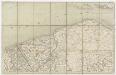
5 Westcapelle, uit: [Belgique 1:40.000]
1 : 40000 Annotatie: Voor aanwezige bladen zie overzichtsblad Bruxelles : Dépot de la Guerre
Zelandiae Comitatus Novissima Tabvla].
1 : 45000 Mollova mapová sbírka Visscher, Nicolaes Jansz. Ottens, Aaltje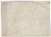
Kaart figuratief van de situatie der Hoofdplaat met de aldaar om en aanleggende schorren en landboorden ...

SLVSA EXPVGNATA | virtute Ill.mi Princ. | MAVRITII NASSAVII; | ARMIS Potentiß. D.D. | ORDINUM BELGICÆ | FOEDERATÆ | Anno MDCIIII
[Amsterdam : Joan Blaeu]
Plan parcellaire de la commune de Lapscheure : avec les mutations
1 : 5000 Royal Library of Belgium Map Room Popp, Philippe Christian (1805-1879) Popp, Philippe Christian (1805-1879)
Plan de la Ville d l'Ecluse en Flandre
1 : 5375 F. de Bakker delin: et sculp: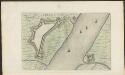
CADSANT : [fortification plan].
[Amsterdam : Joan Blaeu]
SLVYS.
[Amsterdam : Joan Blaeu]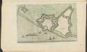
YSENDIJCK : [fortification plan].
[Amsterdam : Joan Blaeu]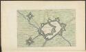
AERDEN BVRGH : [fortification plan].
[Amsterdam : Joan Blaeu]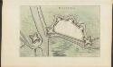
OOSTBVRG : [fortification plan].
[Amsterdam : Joan Blaeu]
Plan parcellaire de la commune de Waterland Oudeman : avec les mutations
1 : 5000 Royal Library of Belgium Map Room Popp, Philippe Christian (1805-1879) Popp, Philippe Christian (1805-1879)
Plan parcellaire de la commune de Watervliet : avec les mutations
1 : 5000 Royal Library of Belgium Map Room Popp, Philippe Christian (1805-1879) Popp, Philippe Christian (1805-1879)
Plan parcellaire de la commune de Houcke : avec les mutations jusqu'en 1842
1 : 5000 Royal Library of Belgium Map Room Popp, Philippe Christian (1805-1879) Popp, Philippe Christian (1805-1879)
Plan parcellaire de la commune de Sainte-Marguerite : avec les mutations
1 : 5000 Royal Library of Belgium Map Room Popp, Philippe Christian (1805-1879) Popp, Philippe Christian (1805-1879)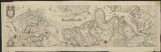
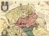
't Meerderdeel van 't Oost-Vrye in Vlaenderen vertonende d'oprechte gelegenth[eit] der landen, fortressen, schansen ende de nieuw bedijckte polders
1 : 40000 [Jac. Mogge] Te Amsterdam : gedruckt by de Wed. Ottens en Zoone ...

Bl. 29 Middelburg, 1905, uit: Atlas A.N.W.B.
1 : 200000 titelvariant: Atlas van Nederland van den A.N.W.B. Toeristenbond voor Nederland; Wielrijders-atlas van Nederland; Annotatie: Titel op bladwijzer: Atlas van Nederland van den A.N.W.B. Toeristenbond voor Nederland; Titel op legendablad: Wielrijders-atlas van Nederland; Voor aanwezige bladen zie overzichtsblad; Annotatie geografische gegevens: De serie bestaat uit 36 bladen ANWB ['s-Gravenhage : A.N.W.B.]
Bl. 29 Middelburg, 1917, uit: Atlas A.N.W.B.
1 : 200000 titelvariant: Atlas van Nederland van den A.N.W.B. Toeristenbond voor Nederland; Wielrijders-atlas van Nederland; Annotatie: Titel op bladwijzer: Atlas van Nederland van den A.N.W.B. Toeristenbond voor Nederland; Titel op legendablad: Wielrijders-atlas van Nederland; Voor aanwezige bladen zie overzichtsblad; Annotatie geografische gegevens: De serie bestaat uit 36 bladen ANWB ['s-Gravenhage : A.N.W.B.]
Carte Particuliere des Environs d'une Partie des Limites en Flandre, Entre les Terres de S.M.I. et Catholicque et Celle des Etats Generaux des Provinces Unies :
1 : 80000 Mollova mapová sbírka Suly, Nicolas Scheurleer, Hendrik
Carte particuliere des environs d'une partie des limites en Flandre, entre les terres de S.M.I. et Catholicque et celle des Etats Generaux des Provinces Unies
1 : 80000 levé par Nicolas Suly ... commencé le 15 frevvrier 1716 à Blanckenberg et fini le 30 maij à L'Ouverslacht E.L. Creite sc. A La Haye : chez H. Scheurleer
Plan parcellaire de la commune de Knocke : avec les mutations
1 : 5000 Royal Library of Belgium Map Room Popp, Philippe Christian (1805-1879) Popp, Philippe Christian (1805-1879)
Plan parcellaire de la commune de Westcappelle : avec les mutations
1 : 5000 Royal Library of Belgium Map Room Popp, Philippe Christian (1805-1879) Popp, Philippe Christian (1805-1879)
Plan parcellaire de la commune de St. Jean-in-Eremo : avec les mutations
1 : 5000 Royal Library of Belgium Map Room Popp, Philippe Christian (1805-1879) Popp, Philippe Christian (1805-1879)
VLISSINGEN.
[Amsterdam : Joan Blaeu]
!['t Meerderdeel van 't Oost-vrye in Vlaenderen [...] [Karte], in: Novus atlas absolutissimus, Bd. 3, S. 124.](https://images-2.georeferencer.com/images/iiif/096937700876/full/,300/0/native.jpg)

