Maps of Parma

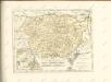
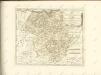
Ducato di Parma et di Piacenza [Karte], in: Theatrum orbis terrarum, sive, Atlas novus, Bd. 3, S. 79.
1 Karte aus Atlas Blaeu, Joan Blaeu, Willem Janszoon
Ducato di Parma et di Piacenza [Karte], in: Novus Atlas, das ist, Weltbeschreibung, Bd. 3, S. 93.
1 Karte aus Atlas Blaeu, Joan Blaeu, Willem Janszoon
Ducato di Parma et di Piacenza [Karte], in: Le théâtre du monde, ou, Nouvel atlas contenant les chartes et descriptions de tous les païs de la terre, Bd. 3, S. 81.
1 Karte aus Atlas Blaeu, Willem Janszoon und Blaeu, Joan Blaeu, Willem Janszoon
Ducato Di Parma Et Di Piacenza [Karte], in: Gerardi Mercatoris et I. Hondii Newer Atlas, oder, Grosses Weltbuch, Bd. 2, S. 288.
1 Karte aus Atlas Mercator, Gerhard und Hondius, Jodocus Jansson, Jan
Ducato di Parma, et di Piacenza. [Karte], in: Novus atlas absolutissimus, Bd. 5, S. 136.
1 Karte aus Atlas Janssonius Offizin

DVCATO | di | PARMA | et di | PIACENZA.
[Amsterdam : Joan Blaeu]

Status Parmensis...

Status Parmensis
1 : 230000 Mollova mapová sbírka Homann, Johann Baptista - dědici
Ducatus Parmensis Et Placentinus
1 : 230000 Mollova mapová sbírka Seutter, Matthäus Seutter, Matthäus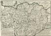
L'Etat du Duc de Parme Contenant Les Duches de Parme et Plaisance et les États Palavicin et de Landi &c.
1 : 350000 Mollova mapová sbírka Nolin, Jean-Baptiste Nolin, Jean Baptiste
Le Cours du Po dans le Milanez
1 : 250000 Mollova mapová sbírka Placide de Sainte-Hélène Berey, Charles Amadeus de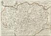
L'Etat du Duc de Parme
1 : 340000 Mollova mapová sbírka Locato, R.P. Omberto Nolin, Jean Baptiste II.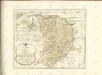

Cours du Po, Milanez.
1 : 250000 Placide de Sainte Helene, Father
Historia Belli in Italia A. 1746. :
1 : 320000 Mollova mapová sbírka Homann, Johann Baptist Homann, Johann Baptista - dědici

Territoria Di Cremona. [Karte], in: Novus Atlas, das ist, Weltbeschreibung, Bd. 3, S. 84.
1 Karte aus Atlas Blaeu, Joan Blaeu, Willem Janszoon
Territorio Di Cremona. [Karte], in: Le théâtre du monde, ou, Nouvel atlas contenant les chartes et descriptions de tous les païs de la terre, Bd. 3, S. 72.
1 Karte aus Atlas Blaeu, Willem Janszoon und Blaeu, Joan Blaeu, Willem Janszoon
Agri Cremonensis Typus. [Karte] Cremae Ditionis Descriptio. [Nebenkarte], in: Theatrum orbis terrarum, S. 296.
1 Karte aus Atlas Ortelius, Abraham Vrients, Jan Baptista
Agri Cremonensis Typus. [Karte] Cremae Ditionis Descriptio. [Nebenkarte], in: Theatrum orbis terrarum, S. 201.
1 Karte aus Atlas Ortelius, Abraham
Agri Cremonensis typvs
1 Karte : Kupferdruck ; 33 x 48 cm Campi; Ortelius s.n.
Territorio Di Cremona. [Karte], in: Theatrum orbis terrarum, sive, Atlas novus, Bd. 3, S. 70.
1 Karte aus Atlas Blaeu, Joan Blaeu, Willem Janszoon

TERRITORIO | DI | CREMONA.
[Amsterdam : Joan Blaeu]

![Ducato di Parma et di Piacenza [Karte], in: Theatrum orbis terrarum, sive, Atlas novus, Bd. 3, S. 79.](https://images-0.georeferencer.com/images/iiif/378613591478/full/,300/0/native.jpg)

