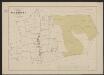
Maps of Overijssel
Ditio Trans-Isulana [Karte], in: Gerardi Mercatoris et I. Hondii Newer Atlas, oder, Grosses Weltbuch, Bd. 1, S. 469.
1 Karte aus Atlas Mercator, Gerhard und Hondius, Jodocus Jansson, Jan
Ditio Trans-Isulana [Karte], in: Novus atlas absolutissimus, Bd. 3, S. 206.
1 Karte aus Atlas Janssonius Offizin
La Seigneurie D'Over-Yssel subdivisée en Trois Parties Sallant, Twente, et Drente [Karte], in: Atlas nouveau, contenant toutes les parties du monde [...], Bd. 2, S. 83.
1 Karte aus Atlas Sanson, Nicolas Jaillot, Alexis Hubert und Mortier, Pieter
Ditio Trans-Isulana.
1 : 480000 [Amsterdam] : Joannes Janssonius excud.
Transiselania Dominium vernaculè Over-Yssel. [Karte], in: Novus Atlas, das ist, Weltbeschreibung, Bd. 1, S. 417.
1 Karte aus Atlas Blaeu, Joan Blaeu, Willem Janszoon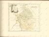

Transiselania Dominium vernaculè Over-Yssel. [Karte], in: Le théâtre du monde, ou, Nouvel atlas contenant les chartes et descriptions de tous les païs de la terre, Bd. 1, S. 450.
1 Karte aus Atlas Blaeu, Willem Janszoon und Blaeu, Joan Blaeu, Willem Janszoon
La Seigneurie d'Over-Yssel : subdivisée en trois parties Sallant, Twente, et Drente / dressée sur les memoires les plus nouveaux par le Sr. Sanson
1 : 250000 Annotatie: Uit: Atlas nouveau, contenant toutes les parties du Monde ... Sanson, Guillaume A Paris : chez H. Iaillot
Transiselania Dominium vernaculè Over-Yssel. [Karte], in: Theatrum orbis terrarum, sive, Atlas novus, Bd. 1, S. 453.
1 Karte aus Atlas Blaeu, Joan Blaeu, Willem Janszoon
TRANSISELANIA | DOMINIVM | vernaculè | OVER-YSSEL.
[Amsterdam : Joan Blaeu]
La Seigneurie d'Over-Yssel, subdivisée en Trois Parties Sallant, Twente, et Drente
1 : 280000 Mollova mapová sbírka Sanson, Guillaume Mortier, Cornelis
La Seigneurie d'Over-Yssel, subdivisée en Trois Parties Sallant, Twente, et Drente
1 : 280000 Mollova mapová sbírka Sanson, Guillaume Jaillot, Alexis Hubert

Carte von Over-Yssel und Drenthe
1 : 170000 Güssefeld, Franz L. von den Hommänischen Erben
TRANSISELANIA | DOMINIVM | vernaculè | OVER-YSSEL.
[Amsterdam : Joan Blaeu]
De Heerlycheyt van Over-Yssel
1 : 380000 Nizozemsko Goos, Abraham C.I. Visscher
Carte von Over-Yssel und Drenthe
1 : 230000 entworfen durch F.L. Güssefeld und hrsg. von den Homännischen Erben. Zu Nürnberg : Homännische Erben
Transiselania Dominvm vernacluè Over-Yssel
1 : 510000 Mollova mapová sbírka Merian, Caspar Merian, Caspar - dědici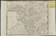
Nieuwe kaart van het Departement van den Ouden Yssel
1 : 435000 C. Covens del C. van Baarsel sculps. Te Amsterdam : bij Mortier Cóvens & Zoon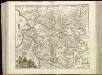
[93][94] Transisalania Provincia vulgo Over-Yssel, uit: Atlas sive Descriptio terrarum orbis
Annotatie: Gedigitaliseerde versie. Amsterdam. Heiloo : Picturae (vervaardiger), 2015. tiff-bestand. Gedigitaliseerd: 07-01-2015; Origineel: Universiteitsbibliotheek Vrije Universiteit (XL.05127.-) ; Netherlands; Titelpagina ontbreekt Wit, Frederik de Amsterdam : Frederick de Wit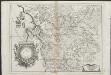
Tran-siselana
1 : 200000 dedicata dal P. cosmografo e lettore Coronelli. [S.l.] : [s.n.]
Over-IJsel.
1 : 300000 [S.l.] : [s.n.]
5de blad Bladwijzer, uit: Topographische kaart van de provincie Gelderland / vervaardigd door W. Kuyk Jzn. ; op steen gegrav. door A. Bayly en J.M. Huart ; gelithogr. door J.M. Huart
1 : 50000 titelvariant: Kaart der provincie Gelderland; Annotatie: Omslagtitel: Kaart der provincie Gelderland; Vervaardigd in opdracht van de Staten van Gelderland; Met register van trigonometrische punten (bl. 4) en bladwijzer (bl. 5) W. Kuyk Jzn fl. 1843; Bayly, A.; Huart, J. M. [S.l. : s.n.]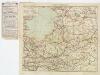
[Kaart], uit: Overijssel en Gelderland
1 : 300000 titelvariant: Midden-Nederland; Ten Brink's reiskaart van Overijssel, Gelderland, Utrecht (oostelijk) en 't Gooi; Annotatie: Ook onder de titel: Midden-Nederland; Titel op omslag: Ten Brink's reiskaart van Overijssel, Gelderland, Utrecht (oostelijk) en 't Gooi Arnhem : Ten Brink
Transisalania Provinvia; Vulgo Over-yffel. [Karte], in: Novus atlas absolutissimus, Bd. 3, S. 211.
1 Karte aus Atlas Janssonius Offizin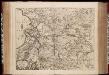
Transisalania Provincia, vulgo Over-Yssel / auctor N. ten Have
1 : 180000 Annotatie: Origineel is Blad 57 in atlas factice Have, N. ten [Amsterdam : C.J. Visscher excudit]
Transisalania vulgo Over-Yssel / auct. N. ten Have
1 : 180000 Have, N. ten Amstelodami : emendata a R. & I. Ottens
Transisalania Provincia vulgo Over-Yssel
1 : 100000 auct. N. ten Have verm. en verb. door J. de Lat, 1743 ; Gerardus Coeck hasce literas sculpsit. Te Deventer : by Jan de Lat
Transisalania Provincia, vulgo Over-IJssel
1 : 190000 auct. N. ten Have emendata a R. & J. Ottens. Amstelodami, : [s.n.]
![Ditio Trans-Isulana [Karte], in: Gerardi Mercatoris et I. Hondii Newer Atlas, oder, Grosses Weltbuch, Bd. 1, S. 469.](https://images-2.georeferencer.com/images/iiif/583396221211/full/,300/0/native.jpg)

