Maps of Flemish Brabant

Le Duché De Brabant [...] [Karte], in: Atlas nouveau, contenant toutes les parties du monde [...], Bd. 2, S. 32.
1 Karte aus Atlas Sanson, Nicolas Jaillot, Alexis Hubert und Mortier, Pieter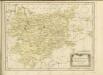

Das Herzogthum Brabant
1 : 310000 Brabantsko
Le Duché de Brabant :
1 : 146000 Mollova mapová sbírka Jaillot, Alexis-Hubert
Le Brabant Espagnols et L'Eveché de Liege &c.
Mollova mapová sbírka Nolin, Jean-Baptiste Nolin, Jean Baptiste
Ducatus Brabantiae
1 : 233000 Mollova mapová sbírka Homann, Johann Baptist Homann, Johann Baptista
Pars Meridionalis Brabantiae continens Dominium Mechliniense Ducatum Arschotanum [...] [Karte], in: Gerardi Mercatoris et I. Hondii Newer Atlas, oder, Grosses Weltbuch, Bd. 1, S. 387.
1 Karte aus Atlas Mercator, Gerhard und Hondius, Jodocus Jansson, Jan
29th Division. March through Belgium and Germany across the Rhine to Bridghead. Sheet 1
1 : 250000 29th Division. March through Belgium and Germany across the Rhine to Bridghead. Sheet 1. Shows route of 29th Division who marched from Renaix in Belgium to Cologne in Germany to secure Rhine bridgehead immediately following the end of the First World War. War Office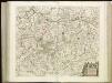
[118][121] Pars meridionalis Brabantiae ..., uit: Atlas sive Descriptio terrarum orbis
Annotatie: Gedigitaliseerde versie. Amsterdam. Heiloo : Picturae (vervaardiger), 2015. tiff-bestand. Gedigitaliseerd: 07-01-2015; Origineel: Universiteitsbibliotheek Vrije Universiteit (XL.05127.-) ; Netherlands; Titelpagina ontbreekt Wit, Frederik de Amsterdam : Frederick de Wit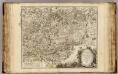
Brabant, Namur Partie Meridionale.
1 : 217500 Robert de Vaugondy, Gilles, 1688-1766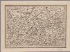
[18], uit: Hydro-Oro und Chorographische General Karte des Koenigreichs der Niederlande und der angrenzenden Länder bis Paris : mit der Angabe der Kunst und Heer-Strassen und der Entfernung der Poststationen / ... zusammengetragen und reducirt von ... Wilhelm Müller
1 : 400000 titelvariant: Generalkarte des Koenigreichs Hannover; Annotatie: 1e supplement bij: Generalkarte des Koenigreichs Hannover (1818) Müller, Wilhelm (fl. 1818) [Hannover : Wilhelm Müller]
L'évêche et l'état de Liege avec les appartenances designées dans les pais voisins
1 : 240000 delinéation nouvelle et exacte aux dépens de Tobie Conrad Lotter, géographe Tob. Con. Lotter sculps. A Augsbourg : [Tobias Conrad Lotter]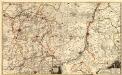
Carte Contenant le Duche de Limbourg et Partie du Dioecese de Liege dediée A Son Altesse Electorale de Baviere
1 : 140000 Mollova mapová sbírka Medtman, Matthias van Husson, Pierre
Le Pais d'Entre Sambre et Meuse
1 : 316000 Mollova mapová sbírka Fer, Nicolas de Inselin, Charles Danet, Guillaume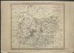
Brabant méridional, divisé en arrondissemens et cantons de justice de paix
1 : 190000 dressé et gravé par C. van Baarsel et Fils. A Amsterdam [etc.] : chez F.J. Weygand
Maastricht 83, uit: [W. Liebenow's Special-Karte von Mittel-Europa]
1 : 300000 titelvariant: W. Liebenow's Mittel-Europa; Annotatie: Titel boven de bladen: W. Liebenow's Mittel-Europa Johannes Wilhelm Liebenow 1822-1897 Hannover : Hermann Oppermann
Maastricht 83, uit: Special-Karte von Mittel-Europa / nach amtlichen Quellen bearbeitet von W. Liebenow
1 : 300000 titelvariant: W. Liebenow's Mittel-Europa; Annotatie: Titel boven de bladen: W. Liebenow's Mittel-Europa Johannes Wilhelm Liebenow 1822-1897 Frankfurt a. M. : Ludwig Ravenstein
Brabantia Dvcatvs
1 : 420000 Mollova mapová sbírka Blaeu, Willem Janszoon Bleau, Willem Janszon
Brabantia Dvcatvs
1 : 100000 Mollova mapová sbírka Merian, Caspar Merian, Caspar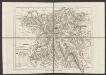
Dioecesis Leodiensis Accurata Tabula. [Karte], in: Gerardi Mercatoris et I. Hondii Newer Atlas, oder, Grosses Weltbuch, Bd. 1, S. 208.
1 Karte aus Atlas Mercator, Gerhard und Hondius, Jodocus Jansson, Jan
L'eveche et l'etat de Liege
1 : 240000 Lotter, Tobias Conrad de Tobie Conrad Lotter
Carte de la principauté de Liege et de ses environs
1 : 150000 Lutych (Belgie) Maire, Christopher Berghes, Georges-Louis de

Pars Medionalis Brabantiae
1 : 220000 Mollova mapová sbírka Wit, Frederik de Covens, Johannes I
Dioecesis Leodiensis accurata tabula
1 : 165000 Belgie jižní Hondius, Henricus H. Hondius
Dioecesis Leodiensis accurata tabula
1 : 165000 Belgie jižní Hondius, Henricus sumptibus Henrici Hondii
Bruxellensis tetrarchia
1 : 130000 Brusel-oblast (Belgie) Visscher, Nicolaus Schenk, Pieter apud Petr Schenk
Leodiensis Dioecesis
1 : 390000 Mollova mapová sbírka Blaeu, Willem Janszoon Blaeu, Joan I.
Dioecesis Leodiensis Accurata Tabula
1 : 170000 Mollova mapová sbírka Valk, Gerhard Allard, Carel
![Le Duché De Brabant [...] [Karte], in: Atlas nouveau, contenant toutes les parties du monde [...], Bd. 2, S. 32.](https://images-2.georeferencer.com/images/iiif/631058282921/full/,300/0/native.jpg)

