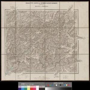
Maps of Sondrio

Touristen-Karte der ostrhätischen Kurorte
1 : 200000 1 Karte Topogr. Anstalt v. Wurster, Randegger & Co. In Commission bei Wurster, Randegger & Co., Winterthur
[Exactissima Helvetiae, Rhaetiae, Valesiae ... tabula]
1 : 850000 9 Karten [Kopie von Adrian Braakman] [chez Pierre Schenk et Adrian Braakman], [Amsterdam]
Atlas novus Reipublicae Helveticae
1 Atlas ([40] Bl., 97 S.) bey Orell, Gessner und Compagnie, Zürich
Karte des Kantons Graubündten [i.e. Graubünden]
1 : 250000 1 Karte Topogr. Anstalt Winterthur, J. Schlumpf Geographisches Institut J. Meier, Zürich
<<Der>> Canton Graubünden
1 : 470000 1 Karte R. am Stein delin. ; Scheurmann sculp. [Orell Füssli], [Zürich]
<<Der>> Canton Graubünden
1 : 470000 1 Karte R. am Stein delin. ; Scheurmann sculp. [Orell Füssli & Cp.], [Zürich]
Karte des Kantons Graubünden
1 : 250000 1 Karte Joh. Wurster & Comp., Winterthur
Karte des Kantons Graubundten [i.e. Graubünden]
1 : 250000 1 Karte J. Wurster u. Comp., Winterthur
<<Der>> Canton Graubünden
1 : 470000 1 Karte R. am Stein delin. ; Scheurmann sculp. [Orell Füssli & Cp.], [Zürich]
<<Der>> Canton Graubünden
1 : 470000 1 Karte R. am Stein delin. ; Scheurmann sculp. [Orell Füssli], [Zürich]
Rhaetia foederata cum confinibus et subditis suis Valle Telina, comitatu Clavennensi et Bormiensi, recenter et accuratißime delineata
1 : 253000 Bormio (Itálie) Walser, Gabriel Seutter, Matthäus sumtibus Matth. Seutteri
Carte de la Suisse avec les plans des cheflieux des 22 cantons
1 : 200000 1 Karte auf 8 Bl. dessinée et publié par Henri Keller ; Lithogr. von J. Schweizer = Charte der Schweiz mit den Grundrissen der Hauptorte der 22 Cantone Keller, Zürich
Le Theatre de Bellone :
Mollova mapová sbírka Schenk, Pieter Braakman, Adriaan
Karte der West-Tiroler und Engadiner Alpen
1 : 250000 Ravenstein, Ludwig Geographische Anstalt von L. Ravenstein
Alpinae seu Foederatae Rhaetiae Subditarumque ei Terrarum nova descriptio. [Karte], in: Gerardi Mercatoris et I. Hondii Newer Atlas, oder, Grosses Weltbuch, Bd. 1, S. 268.
1 Karte aus Atlas Mercator, Gerhard und Hondius, Jodocus Jansson, Jan
Alpinae seu Foederatae Rhaetiae Subditarumque ei Terrarum nova descriptio. [Karte], in: Novus Atlas, das ist, Weltbeschreibung, Bd. 1, S. 248.
1 Karte aus Atlas Blaeu, Joan Blaeu, Willem Janszoon
Reisekarte von Graubünden, Schweiz
1 : 300000 Graubünden (Švýcarsko) Direktion der Rhätischen Bahn
Alpinae seu Foederatae Rhaetiae Subditarumque ei Terrarum nova descriptio. [Karte], in: Novus atlas absolutissimus, Bd. 4, S. 251.
1 Karte aus Atlas Janssonius Offizin
Distanzenkarte von der Schweiz
1 : 200000 1 Karte in 8 Teilen nach den besten Hülfsquellen bearb. von R. Huber Wagner, Bern
Rhaetia Foederata cum Confinibus et Subditis suis Valle Telina, Comitatu Clavennensi et Bormiensi, recenter et accuratißimé delineata
1 : 320000 Mollova mapová sbírka Walser, Gabriel Silbereisen, Andreas Seutter, Matthäus
Karte des Kantons Graubünden
1 : 250000 Mengold, G.W. ; Held, Leonz Verlag der Leonhard Hitz'schen Buchhandlung
[Kaart], uit: Reisekarte von Graubünden, Schweiz / Kümmerly & Frey
1 : 300000 Kümmerly + Frey, Bern Chur : Direktion der Rhätischen Bahn
Canton Graubünden
1 : 470000 Am Stein, Rudolf ; Scheuermann, Johann Jakob [Orell Füssli]
Rhætia foederata cum confinibus et subditis suis Valle Telina, comitatu Clavennensi et Bormiensi
1 Karte : Kupferdruck ; 47 x 55 cm Seutter; Silbereisen; Walser Matthäus Seutter
Rhætia foederata cum confinibus et subditis suis Valle Telina, comitatu Clavennensi et Bormiensi
1 Karte : Kupferdruck ; 47 x 55 cm Seutter; Silbereisen; Walser Matthäus Seutter
Alpinae seu foederatae Rhaetiae subditarumque ei terrarum nova descriptio
1 : 385000 Raetie Sprecher von Bernegg, Fortunat Blaeu, Willem Janszoon Guiljelmus Blaeuw
Karte des Kantons Graubünden
1 : 250000 Mengold, G.W. Verlag der Leonhard Hitz'schen Buchhandlung
Karte der West-Tiroler und Engadiner Alpen
1 : 250000 Engadin (Švýcarsko) Ravenstein, Ludwig L. Ravenstein
Karte der West-Tiroler und Engadiner Alpen
1 : 250000 Engadin (Švýcarsko) Ravenstein, Ludwig Geographische Anstalt von L. Ravenstein