Maps of Bavaria

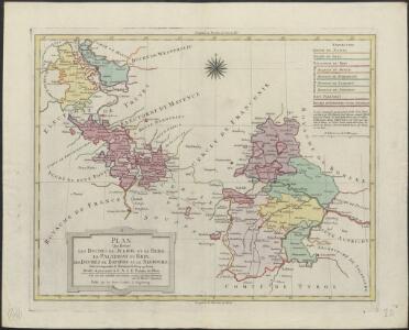
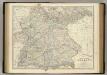
Plan qui réuni les duchés de Julier, et de Berg, le palatinat du Rhin, les duchés de Baviere et de Neubourg, sans y comprendre le marquisat de Berg op Zoom
1 : 1250000 par son très humble, très soumis, et très obeisant serviteur De St. Michel, Ingenieur A Augsbourg : publié par les freres Lotter
[Das Deutsches Reich, Blatt 3]
Adolf Stieler's Handatlas über alle Theile der Erde und über das Weltgebäude Stieler, Adolf Justus Perthes
Allemagne du Sud.
1 : 1550000 Migeon, J.
Süddeutschland
Germany - South. Pergamon World Atlas.
1 : 1250000 Polish Army Topography Service
Blatt 97: Metzingen, uit: Topographische Karte von Württemberg im Massstab 1:25.000 / hrsg. vom Statistischen Landesamt
1 : 25000 titelvariant: Topographische Karte des Königreichs Württemberg im Massstabe 1:25.000; Annotatie: Titelvariant: Topographische Karte des Königreichs Württemberg im Massstabe 1:25.000; Incompleet (4 bl. aanwezig) Württembergisches Statistisches Landesamt [Stuttgart : Statistisches Landesamt]
Empire of Germany (southern portion).
1 : 1050000 Johnston, Alexander Keith
Süddeutchland

Post- und Reise- Karte vom Bayern und den angrenzenden Ländern und Ländertheilen mit besonderer Bezugnahme auf die schon bestehenden und projektirten Eisenbahnen ausgedehnt bis Basel, Düsseldorf, Dresden, Prag, Linz, Gastein, Insbruck und Bodensee, mit Entfernungs-Angabe der Poststationen
1 : 1100000 Bavorsko (Německo) Obernetter, Johann Baptist Verlag von Mey & Widmayer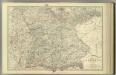
Empire of Germany (southern portion).
1 : 1050000 Johnston, Alexander Keith

Plan qui réüni les duchés de Julier, et de Berg, le palatinat du Rhin, les duchés de Baviere et de Neubourg
1 Karte : Kupferdruck ; 44 x 56 cm Saint Michel; Lotter; Lotter publié par les freres Lotter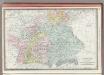
Germany Southern Portion.
1 : 1430000 Rand McNally and Company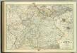
Empire of Germany (southern portion).
1 : 1050000 Johnston, W. & A.K.
Het oorlogstooneel van 1796 in Duitschland
1 : 1850000 Annotatie: Kaart IV in: Prins Frederik der Nederlanden en zijn tijd / F. de Bas. - Dl. 1; Annotatie geografische gegevens: Inzetkrt: Het slagveld van Würzburg op 3 september. - 1:740.000 Schiedam : H.A.M. Roelants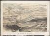
Stannard & Son's, panoramic birds-eye view of the French & Prussian provinces, on the banks of the Rhine, shewing all the fortresses belonging to each army, with the railways & frontier boundaries of each country
1 : 1
Baden, Würtemberg, Baiern
Schul-Atlas in 36 Karten Völter, Daniel Verlag der J.M. Dannheimer'schen Buchhandlung
Süddeutschland
Volksschul-Atlas über alle Teile der Erde Lange, Henry Druck und Verlag von Georg Westermann
Germany.
1 : 1500000 Colton, G.W.
Western Germany.
1 : 1340000 Arrowsmith, John
Germany SW.
1 : 1050000 Johnston, Alexander Keith, 1804-1871
Neue vollkomene Landkarten des h. Röm. Reichs, Ober und Nieder Rheinisch- Fränkisch- Schwäbisch- und theils Bayrischen Kraises, samt denenselber angelegner Orten, an einem und dann Anderntheils, derer dem röm. Reich, durch Franckreich in dem vergangen und noch lauffenden Seculo entzogenen Ländern, Elsaß, Lothring, Burgund, Metz, Toul, Verdun, nicht weniger denen neu gemachten dependentien mit Anmerkung aller vornehmer Ort und Vöstungen, vornemlich am Rhein-Strom, von Basell, bis unterhalb Cölln etc. etc
1 : 1100000 Alsasko (Francie) Endter, Martin Martin Endter
Composite I, II, VI, VII: Karte Des Oesterreichischen Kaiserstaates.
1 : 576000 Scheda, Josef
W. Germany.
1 : 1300000 Arrowsmith, John
Neue Vollkomene Landkarten. Des Röm: Reichs Ober und Nider Rheinisch-Fränkisch-Schwäbisch- und theils Bayrischen Kraises, samt denenselber etc angelegner Orten an einem Und dann Anderntheils, derer dem Röm: Reich, durch Franckreich in dem vergangen und noch laufenden Seculo entzogenen Ländern, Elsaß, Lothring, Burgund, Metz, Toul, Verdün
Mollova mapová sbírka
Germany No.4.
1 : 1375000 Colton, G.W.
Southern Germany.
1 : 1710720 Fullarton, A. & Co.
SW Deutschland.
1 : 4100000 Brudin, J. L.; Stieler, Adolf