Maps of North Holland

Vernieuwde kaart van Noordholland en Westfriesland, benevens het voornaamste gedeelte van Rhynland en daar aan grenzende landen
1 : 80000 met alle naauwkeurigheid gevolgd naar de caerte van Joost Jansz Beelsnyder Ao. 1575, door Jan van Jagen, 1778 C. Bogerts sculps. Te Amsterdam : uitgeg. by Yntema en Tieboel
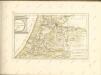
Nieuwe kaart van het departement van Texel, verdeeld in VII ringen
1 : 400000 C. Covens del. C. van Baarsel sculp. Te Amsterdam : bij Mortier Covens en Zoon
Afbeeldinge vande reviere de Zaane inde Jare MC en MCCL &c.
1 : 300000 [S.l.] : [s.n.]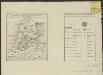
Algemeen kaartje, aantonende de uitgestrektheid en verdeling der bladen van de Kaart van een gedeelte der Departementen van Amstelland, Maasland en Utrecht
1 : 530000 onder directie en naar de geodesische waarnemingen van ... C.R.T. Krayenhoff ... te zamen gesteld en getekend door ... J.E. van Gorkum C. van Baarsel, sculp. Amsterdam : Mortier, Covens en Zoon
Provincie Noordholland waterstaatkundig
1 : 100000 Annotatie geografische gegevens: Legenda Alphen a/d Rijn : Samsom / (Haarlem : Joh. Enschedé en Zonen)
Hollandiae Pars Septentrionalis, Vulgo Westvriesland en 'T Noorder Quartier. [Karte], in: Le théâtre du monde, ou, Nouvel atlas contenant les chartes et descriptions de tous les païs de la terre, Bd. 1, S. 422.
1 Karte aus Atlas Blaeu, Willem Janszoon und Blaeu, Joan Blaeu, Willem Janszoon
Hollandiæ pars septentrionalis, vulgo Westvriesland en 't Noorder Quartier
1 : 115000 [Willem Jansz. en Joan Blaeu] Amsterdami : apud Guiljelmum et Joannem Blaeu
HOLLANDIÆ | PARS SEPTENTRIONALIS, | Vulgo | WESTVRIESLAND en | 'T NOORDER QVARTIER.
Amsterdami | Apud Guiljelmum et Ioannem Blaeu.

Hollandiae Pars Septentrionalis, Vulgo Westvriesland en 'T noorder Quartier. [Karte], in: Theatrum orbis terrarum, sive, Atlas novus, Bd. 1, S. 424.
1 Karte aus Atlas Blaeu, Joan Blaeu, Willem Janszoon
La Rhinlande Amstellande et terres circõvosines
1 : 300000 auctore Balt[hasar] Flo: a Berkêrode. [Amsterdam] : [Jacob Aertsz. Colom]
Parte septtentrionale dell'Hollanda, vulgo Westvriesland en tNoorder quartier
1 : 120000 nel laboratorio del P. cosmografo Coronelli, in Venetia. Venetia : Coronelli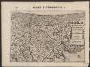
Rhinolandiæ Amstelandiæ et circumjacent. aliquot territoriû accurata descriptio
1 : 360000 Auctore Balth. Florentio a Berckenrode. Amstelodami : sumptibus Henrici Hondii.
Hollands Noorderkwartier in 1288 / naar oude oorkonden ontworpen door G. de Vries, Az. ; [gegraveerd door] C. Eckstein
1 : 88000 Annotatie: Behoort bij: De kaart van Hollands Noorderkwartier in 1288 / door G. de Vries, Az. - Amsterdam : Van der Post, 1864, in: Verhandelingen der Koninklijke Nederlandse Akademie van Wetenschappen, Afd. Letterkunde, 2e dl/III Gerrit de Vries Azn. 1818-1900; Carel Alphons Eckstein 19e E. Amsterdam : Van der Post
't Hoogh-Heemraetschap vande uytwaterende sluysen in Kennemerlandt ende West-Vrieslandt

Tabula Hollandiae Borealis, cognitae olim sub nomine Kennemariae et Westfrisiae
1 : 140000 in majores et minores ditiones cum cura distinctae et editae in lucem per Petrum Schenk. Tot Amsterdam : by Pieter Schenk, op den Vygendam, in Sansons Atlas
Rhenolandia, Amstelandia Et Circumiacentia aliquot Territoria, cum Aggeribus omnibus, Terminisque suis. [Karte], in: Novus atlas absolutissimus, Bd. 3, S. 179.
1 Karte aus Atlas Janssonius Offizin
Kennemaria et Westfrisia vulgo et vernacule Noord-Holland tam in minores quam praecipuas ditiones
1 : 150000 peraccurate distincta et edita per Nicolaum Visscher Amst. Bat. Amst. Bat. : per Nicolaum Visscher

Rhenolandia, Amstelandia et circumjacentia aliquot territoria, cum aggeribus omnibus, terminisq[ue] suis / accurate et distincte edita per Nicolaum Visscher
1 : 180000 Annotatie: Cum privilegio Ordinum Hollandiae et West-Frisiae; Met opdracht van Nicolaus Visscher aan Johannes Hudde; Annotatie geografische gegevens: West boven; Met 2 schaalstokken Nicolaes Jansz Visscher sr 1618-1679 [Amsterdam : Nicolaus Visscher]
Partie du Comté de Hollande où sont les environs d'Alcmaar, de Medenblick, d'Enckhuysen, dEdam &c.
1 : 300000 gravé par Guill. Delahaye. [Paris[ : par le sr Robert géog. ord. du roi
Hollandiae Pars Septentrionalis, Vulgo Westvriesland en 'T Noorder Quartier. [Karte], in: Novus Atlas, das ist, Weltbeschreibung, Bd. 1, S. 391.
1 Karte aus Atlas Blaeu, Joan Blaeu, Willem Janszoon

Hollandiae pars Septentrionalis, Vulgo Westvriesland en 'tnoorder quartier. [Karte], in: Novus atlas absolutissimus, Bd. 3, S. 182.
1 Karte aus Atlas Janssonius Offizin
[Nort-Hollandt Oder West-Vrieslandt.] [Karte], in: Gerardi Mercatoris et I. Hondii Newer Atlas, oder, Grosses Weltbuch, Bd. 1, S. 456.
1 Karte aus Atlas Mercator, Gerhard und Hondius, Jodocus Jansson, Jan
[Map of the northern part of Noord-Holland]
1 : 100000 [S.l.] : [s.n.]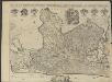
't Hoog-Heemraetschap van de uytwaterende sluysen in Kennemerlant ende West-Frieslant
1 : 60000 [opgemeten door Jan Jansz. Dou] [S.l] : [s.n]
't Hoogh-Heemraetschap vande uytwaterende sluysen in Kennemerlandt ende West-Frieslandt


