Maps of Mecklenburg County

Wightman
1 : 24000
Wightman
1 : 24000
Chase City
1 : 62500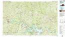
South Boston
1 : 100000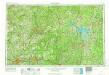
Greensboro
1 : 250000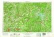
Greensboro
1 : 250000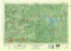
Greensboro
1 : 250000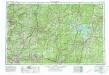
Greensboro
1 : 250000
Seat of War in America
Seat of War in America. Published by Bacon & Co. in London, Seat of the War in America shows the region between Baltimore and Petersburg and the placement of troops and fortifications along the border between the Confederacy and the Union. It is notable how many batteries are placed around the Confederate capital of Richmond, as well as marking out the railway lines that connected the region. At the top of the map are publishing adverts for Colton productions, as well as a list of the Union and Confederate generals and a table detailing export amounts in 1860, with cotton being the largest figure. Bacon & Co.
War Telegram Marking Map.
1 : 490000 Prang, L. & Co.
War Telegram Marking Map.
War Telegram Marking Map. Produced by Prang in 1862, this War Telegram Marking Map was published for sale with the intension that telegraph communications within what the map calls ‘Virginia Territory’, the area running from Baltimore to Petersburg across the Union and Confederate line, would me marked down. The explanation key on the map comments that red and blue pencils would be provided alongside the map so that Union telegraph communications could be marked in red and Confederate communications in blue. This map is unmarked. L. Prang & Co.
North-Carolina.
Scott, Joseph
A map of Virginia : formed from actual surveys and the latest as well as the most accurate observations / by James Madison ; drawn by Wm. Davis ; with extensive additions and corrections to the year 1818.
from Charts and maps
Der amerikanische Kriegsschauplatz zwischen Washington und Richmond
1 : 1000000 Richmond (Virginie) Petermann, August Debes, Ernst Justus Perthes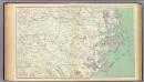
Gen. map III.
1 : 633600 United States. War Department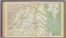
Gen. map II.
1 : 633600 United States. War Department
North Carolina With Part Of Virginia & South Carolina.
1 : 506880 Colton, J. H.
Strategic War Points of the United States no.1: the country round Washington, the Chesapeake and the Potomac
Strategic War Points of the United States no.1: the country round Washington, the Chesapeake and the Potomac. J. Wyld
War telegram marking map
1 : 490000 L. Prang & Co Lith. of J. Bien
Virginia and Maryland
1 : 1500000 Maryland Heřman, Augustin Faithorne, Henry Aug. Herman and Thomas Withinbrook
The new war map of Virginia, Maryland & Pennsylvania
1 : 510000 Russel, B.B. (Benjamin B.)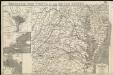
Strategic war points of the United States

Prang's War Map. North Carolina Coast Line
Prang's War Map. North Carolina Coastline L. Prang & Co.
Map to illustrate the 1862 (Virginia) Campaign
Map to illustrate the 1862 (Virginia) Campaign. Map to illustrate the American Civil War of sixty years previously. This small map details the areas of Virginia around the capitals of Washington, D.C. and Richmond where a great amount of fighting took place in 1862 and indeed across the war period. Several places on the map, such as Fredericksburg, Petersburg and Manassas Junction/Bull Run witnessed heavy clashes during the conflict. The map also details railway routes in the region. War Office
Richardson's Map Of West Virginia.
1 : 760320 Richardson, C.S.
NOVA VIRGINIÆ TABVLA
DGrijp Sculpt [Amsterdam : Joan Blaeu]
Prang's Naval Expedition Maps: North Carolina coast line
Prang's Naval Expedition Maps: North Carolina coast line L. Prang & Co.
Map Of The Seat Of War.
1 : 633600 Monk, Jacob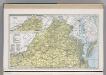
Virginia.
1 : 1271000 Hammond, C.S.

