Maps of Pittsylvania County

Ingram
1 : 24000
Ingram
1 : 24000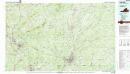
Danville
1 : 100000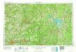
Greensboro
1 : 250000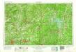
Greensboro
1 : 250000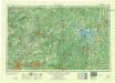
Greensboro
1 : 250000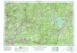
Greensboro
1 : 250000
Der amerikanische Kriegsschauplatz zwischen Washington und Richmond
1 : 1000000 Richmond (Virginie) Petermann, August Debes, Ernst Justus Perthes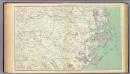
Gen. map III.
1 : 633600 United States. War Department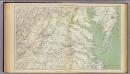
Gen. map II.
1 : 633600 United States. War Department
Strategic War Points of the United States no.1: the country round Washington, the Chesapeake and the Potomac
Strategic War Points of the United States no.1: the country round Washington, the Chesapeake and the Potomac. J. Wyld
War telegram marking map
1 : 490000 L. Prang & Co Lith. of J. Bien
The new war map of Virginia, Maryland & Pennsylvania
1 : 510000 Russel, B.B. (Benjamin B.)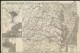
Strategic war points of the United States

A new and accurate map of North Carolina in North America
1 : 1147000
Prang's Naval Expedition Maps: North Carolina coast line
Prang's Naval Expedition Maps: North Carolina coast line L. Prang & Co.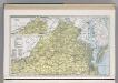
Virginia.
1 : 1271000 Hammond, C.S.
One Hundred & Fifty Miles Around Richmond.
1 : 887040 Magnus, Charles
Shell Highway Map of Delaware - Maryland, Virginia, W. Virginia. (western portion).
1 : 950400 Shell Oil Company
Virginia.
1 : 1700000 Cram, George Franklin; Davis, Ellis Arthur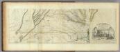
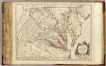
Map of the most Inhabited part of Virginia containing ... Maryland. (Southern Section)
1 : 650000 Jefferys, Thomas
Carte de la Virginie et du Maryland dressée sur la grande carte angloise de Mrs. Josué Fry et Pierre Jefferson, / par le Sr. Robert de Vaugondy, géographe; Groux.
from John H. Levine Collection Robert de Vaugondy; Mrs. Josué Fry et Pierre Jefferson,
Virginie, Maryland.
1 : 870000 Robert de Vaugondy, Gilles, 1688-1766
Nova Virginiae Tabula [Karte], in: Le théâtre du monde, ou, Nouvel atlas contenant les chartes et descriptions de tous les païs de la terre, Bd. 2, S. 318.
1 Karte aus Atlas Blaeu, Willem Janszoon und Blaeu, Joan Blaeu, Willem Janszoon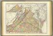
Virginia.
1 : 865000 Rand McNally and Company
Lloyd's Military Campaign Charts: Virginia
Lloyd's Military Campaign Charts, showing the principal places of interest, compiled from official data by Gen. E.L. Viele and C. Haskins. Published under the auspices of the American Geographical and Statistical Society. Virginia.
Nova Virginiae Tabula [Karte], in: Novus Atlas, das ist, Weltbeschreibung, Bd. 2, S. 325.
1 Karte aus Atlas Blaeu, Joan Blaeu, Willem Janszoon
(Virginia, N. Carolina) Railroad Map of the United States.
1 : 506880 Rand McNally and Company

