Maps of Africa
Affricae Tabvla Nova
1 : 30420000 1 Karte : Holzschnitt ; 30 x 35 cm Münster, Sebastian [Sebastian Henricpetri]
Afrika
E. von Sydow's Schul-Atlas in sechs und dreissig Karten Sydow, Emil von bei Justus Perthes
Nieuwe kaart van Africa
1 : 57500000 [S.l.] : [s.n.]
Africa XVIII. Nova Tabula [Karte], in: Geographia universalis vetus et nova complectens Claudii Ptolemaei Alexandrini enarrationis libros VIII, S. 350.
1 Karte aus Atlas Münster, Sebastian [und Ptolemaeus, Claudius]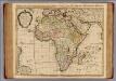
Carte d'Afrique.
1 : 21000000 L'Isle, Guillaume de, 1675-1726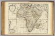
Carte d'Afrique.
1 : 21000000 L'Isle, Guillaume de, 1675-1726
Africa
Schul-Atlas über alle Theile der Erde nach dem neuesten Zustande, und über das Weltgebäude Stieler, Adolf bei Justus Perthes
Carte d'Afrique / ... par Guillaume Delisle ; J. Kondet schulpsit
1 : 22500000 Isle, Guillaume de l'; Kondet, J. Amsterdam : I. Covens et C. Mortier
Neueste Karte von Africa
Grosser Hand-Atlas über alle Theile der Erde in 170 Karten Meyer, J. Verlag des Bibliographischen Instituts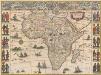
Africae nova descriptio. [Karte], in: Novus Atlas, das ist, Weltbeschreibung, Bd. 2, S. 243.
1 Karte aus Atlas Blaeu, Joan Blaeu, Willem Janszoon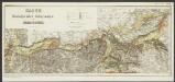
Africae nova descriptio. [Karte], in: Le théâtre du monde, ou, Nouvel atlas contenant les chartes et descriptions de tous les païs de la terre, Bd. 2, S. 281.
1 Karte aus Atlas Blaeu, Willem Janszoon und Blaeu, Joan Blaeu, Willem Janszoon
Afrika
Hand-Atlas über alle Theile der Erde nach dem neuesten Zustande und über das Weltgebäude Stieler, Adolf bei Justus Perthes
Afrika
Hand-Atlas über alle Theile der Erde nach dem neuesten Zustande und über das Weltgebäude Stieler, Adolf bei Justus Perthes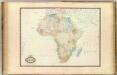
Afrique.
1 : 19200000 Garnier, F. A., 1803-1863
Homannův atlas světa
1 : 12500000
Afrika
Stieler's Hand-Atlas Stieler, Adolf bei Justus Perthes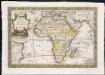
L'Afrique, dressée sur les relations e nouvelles decouvertes de differens voyageurs, conformes aux observations astronomiques
1 : 1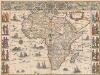
Africae nova descriptio. [Karte], in: Theatrum orbis terrarum, sive, Atlas novus, Bd. 2, S. 288.
1 Karte aus Atlas Blaeu, Joan Blaeu, Willem Janszoon
Africa.
1 : 37000000 Rand McNally and Company
AFRICAE emendata DESCRIPTIO
Afrika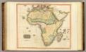
Africa.
1 : 20000000 Thomson, John
Africa
Neuester Schul-Atlas Walch, Johann im Verlag bei Joh. Walch
Afrique physique
Vidal de La Blache, Paul
Afrika
1 : 30410000 Afrika Handtke, Friedrich Hübner C. Flem[m]ing
Afrika.
1 : 30000000 Flemming, Carl
Carte d'Afrique, dressée pour l'usage du Roy
1 : 18000000 par Guillaume Delisle Premier geographe de sa Majesté de l'Academie Royale des sciences I. Kondet schulpsit Á Amsterdam : chez J. Covens et C. Mortier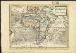
Africa
1 : 1
Africa ex Magnae Orbis Terrae Descriptione
Rasciotti, Donato; Mazza, Giovanni Battista
Africae Tabula Nova. [Karte], in: Theatrum orbis terrarum, S. 20.
1 Karte aus Atlas Ortelius, Abraham