Maps of Belarus

Tabula noua Poloniæ, Vngariæ, & Russiæ
1 : 3700000 1 Karte : Holzschnitt ; 28 x 36.5 cm Ptolemaeus, Claudius Apud Hugonem à Porta
Ostmitteleuropa 1772
Ostmitteleuropa Kunz, Andreas ; Treiling, Thomas
Tabula nova totius regni Poloniae
1 : 4050000 Litva Sanson, Nicolas Visscher, Nicolaus apud Nicolaum Vißcher

Ostmitteleuropa 1815
Ostmitteleuropa Kunz, Andreas ; Johnen, Bettina ; Moeschl, Joachim Robert
[Geschichtlich-geographische Entwickelung des Zuwachses und der Abnahme des polnischen Reiches vom Jahre 992 bis zum Jahre 1831, dargestellt in fünf Karten] : II. Karte von Polen unter dem Jagellonen, 1386-1572
1 : 4800000 entw. u. gez. durch F.A. von Witzleben [Berlin] : [Reimer]
Westliches Russland
1 : 2000000 Evropa východní Handtke, Friedrich Carl Flemming
Estats de la couronne de Pologne
1 : 2800000 Evropa východní Jaillot, Alexis-Hubert H. Jaillot
ESTATS DE LA COURONNE DE POLOGNE
1 : 2800000 Evropa východní Jaillot, Alexis-Hubert H. Jaillot
Regni Poloniae Magniquae Ducatus Lithuaniae Nova et exacta tabula
1 : 3000000 Litva Homann, Johann Baptist Starowolski, Szymon a Ioh. Bapt. Homanno
Regni Poloniae et Ducatus Lithuaniae Voliniae, Podoliae Ucraniae Prussiae, Livoniae et Curlandiae descriptio [Karte], in: Novus atlas absolutissimus, Bd. 1, S. 93.
1 Karte aus Atlas Janssonius Offizin
(La Pologne)
1 : 13000000 Bruyset, Jean-Marie; Schneider, J. H.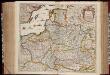
Regni Poloniae et ducatus Lithvaniae Voliniae, Podoliae Vcraniae Prvssiae, Livoniae et Cvrlandiae / descriptio emendata per F. de Wit Amstelodami
1 : 3000000 Annotatie: Rechtsboven: 14; Origineel is Blad 132 in atlas factice; Annotatie geografische gegevens: Met schaalstok: 15 Duytsche Mylen Frederick de Wit 1630-1706 [Amsterdam : F. de Wit]
Estats de la couronne de Pologne : presenté a monseigneur le duc de Bourgogne
1 : 1350000 par son [...] serviteur H. Jaillot A Amsterdam : che[z] Reinier & [Josua] Ottens
Regni Poloniae Magnique Ducat[us] Lithuaniae Nova et exacta Tabula
1 : 3000000 Homann, Johann Baptist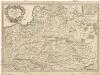
Estats de la couronne de Pologne
1 : 2600000 Evropa východní Sanson, Guillaume Cordier, Louis chez H. Jaillot
Mappa geographica ex novissimis observationibus repraesentans Regnum Poloniae et Magnum Ducatum Lithuaniae
1 : 2000000 cura et sumptibus Tobiae Conradi Lotter Aug[usta] Vind[elicorum] : sumptibus Tobiae Conradi Lotter
Regni Poloniae magnique ducatusq. Lithuaniae nova et exacta tabula
1 : 3130000 Bělorusko Homann, Johann Baptist Starowolski, Szymon Homannovi dědicové
REGNI POLONIAE MAGNIQUE DUCATUS LITHUANIAE Nova et exacta tabula
1 : 3200000 Bělorusko Homann, Johann Baptist Starowolski, Szymon Homannovi dědicové
Regni Poloniae magnique ducatusq. Lithuaniae nova et exacta tabula
1 : 3130000 Bělorusko Homann, Johann Baptist Starowolski, Szymon Homann Erben
Regni Poloniae magnique ducat[us] Lithuaniae nova et exacta tabula
1 : 3041000 Bělorusko Homann, Johann Baptist Starowolski, Szymon â Iohanne Bapt. Homanno
Mappa geographica Poloniae, in partes suas majores Austriac. Russic. et Borrusic
1 : 2920000 Polsko per Hommanianos Heredes
[Geschichtlich-geographische Entwickelung des Zuwachses und der Abnahme des polnischen Reiches vom Jahre 992 bis zum Jahre 1831, dargestellt in fünf Karten] : I. Karte von Polen unter den Piasten vom jahre, 932-1386
1 : 4800000 entw. u. gez. durch F.A. von Witzleben [Berlin] : [Reimer]
Kirchenprovinzen Gnesen u. Riga im XIII. Jahrh.
1 : 24000000 Gniezno, Riga, Kirchenprovinz
[Geschichtlich-geographische Entwickelung des Zuwachses und der Abnahme des polnischen Reiches vom Jahre 992 bis zum Jahre 1831, dargestellt in fünf Karten] : V. Karte der Wiederherstellung Polens, 1807-1831
1 : 4800000 entw. u. gez. durch F.A. von Witzleben [Berlin] : [Reimer]
[Geschichtlich-geographische Entwickelung des Zuwachses und der Abnahme des polnischen Reiches vom Jahre 992 bis zum Jahre 1831, dargestellt in fünf Karten] : III. Karte von Polen von dem Aussterben der Jagellonen bis zur ersten Theilung, 1572-1772
1 : 4800000 entw. u. gez. durch F.A. von Witzleben [Berlin] : [Reimer]
Regni Poloniae Magnique Ducatus Lithuaniae Nova et exacta Tabula ad mentem Starovolcii descripta à Ioh. Bapt. Homanno Sac. Caes. Mai. Geographo
Polen, Litauen Homann, Johann Baptist
Kirchenprovinzen Gnesen, Riga u. Lemberg XV. Jahrh.
1 : 24000000 Ostmitteleuropa Kirchenprovinz
Herzogthum Warschau 1808
1 : 20000000 Herzogtum Warschau