Maps of Eure-et-Loir

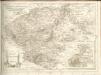
La Beauce
1 Karte : Kupferdruck ; 41 x 56 cm Sanson; Robert de Vaugondy; Somer chez le Sr. Robert geographe du roy quai de l'Horloge du Palais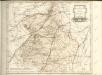

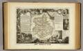
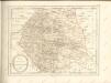
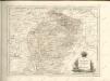
Département d'Eure et Loir
1 Karte : Kupferdruck ; 49 x 48 cm Houdan au bureau de l'atlas national de France rue Serpente n.o 15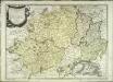
La Beauce
1 Karte : Kupferdruck ; 41 x 56 cm Sanson; Mariette; Somer chez Pierre Mariette rue St. Iacques a l'Esperance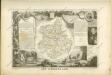
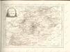
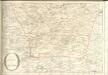
Dept. De L'Eure et Loir.
1 : 568000 Levasseur, Victor.
Carnutes, evesché de Chartres
1 Karte : Kupferdruck ; 42 x 54 cm Sanson; Robert de Vaugondy ches le S. Robert g. o. du roi quai de l'Horloge du Palais
[Chartres]
1 Blatt : 60 x 91 cm Brunet; Desbruslins s.n.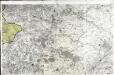
[Vendôme]
1 Blatt : 60 x 91 cm s.n.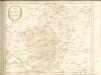
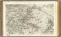
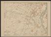
28 Vendome.
1 : 86400 Cassini family; Cassini, Cesar-Francois, 1714-1784
Carte de Beauce
1 Karte : Kupferdruck ; 11 x 16 cm Sebastian Cramoisy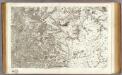
27 Chartres.
1 : 86400 Cassini family; Cassini, Cesar-Francois, 1714-1784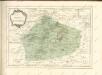

Gowernement de Chartres
1 Karte : Kupferdruck ; 11 x 15 cm Sebastian Cramoisy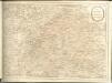

Plan zur Schlacht bei Orléans am 3. December
1 : 40000 Buchh. des Großherzogl. Staatsverl. [u.a.]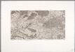
Flle. 10. Rambouillet, uit: Carte topographique des environs de Versailles dite "Carte des chasses du Roi"
1 : 28800 titelvariant: Carte des chasses du Roi; Annotatie: Herdruk van originele koperplaten; Oorspr. uitg.: 1764-1807; Voor aanwezige bladen zie overzichtsblad; Annotatie geografische gegevens: Opname: 1764-1773 [Paris : IGN]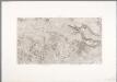
Flle. 11. Arpajon, uit: Carte topographique des environs de Versailles dite "Carte des chasses du Roi"
1 : 28800 titelvariant: Carte des chasses du Roi; Annotatie: Herdruk van originele koperplaten; Oorspr. uitg.: 1764-1807; Voor aanwezige bladen zie overzichtsblad; Annotatie geografische gegevens: Opname: 1764-1773 [Paris : IGN]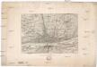
Orléans
1 : 20000 Orléans (Francie)
Orleans
1 Plan : Kupferdruck ; 11 x 15 cm Sebastian Cramoisy
Plan de la ville d'Orleans
1 Plan : Kupferdruck ; 39 x 47 cm Perdoux chéz Perdoux libraire place du Martroy
Chartres
1 Plan : Kupferdruck ; 11 x 15 cm Sebastian Cramoisy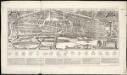
Plan et profil au naturel de la ville d'Orleans
1 : 1