Maps of Richmond

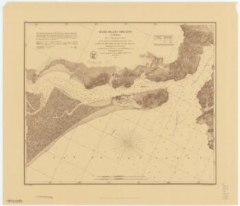
Mare Island Straits, California from a trigonometrical survey under the direction of A.D. Bache, Superintendent of the Survey of the Coast of the United States.
1 : 130000 Relief shown by hachures. Depths shown by soundings. Shows drainage, buildings, wharves, etc. Facsimile. "Reproduced from the annual reports by permission of United States Coast & Geodetic Survey." Oriented with north toward upper left. Includes text and table of abbreviations. "No. 61." United States Coast Survey., P. Witzel (Peter), Rose Research Austin, Tex. : Rose Research
San Pablo Bay, Carquines Straits.
1 : 455000 Stuart, F. D. (Fred. D.)
Mare Island
1 : 62500
Mare Island
1 : 62500
Mare Island
1 : 62500
Mare Island
1 : 62500
San Francisco Quadrangle. Topography.
1 : 62500 Lawson, Andrew C.
San Francisco
1 : 62500
San Francisco
1 : 62500
San Francisco
1 : 62500
San Francisco
1 : 62500
San Francisco
1 : 62500
San Francisco
1 : 62500
San Francisco
1 : 62500
San Francisco
1 : 62500
San Francisco
1 : 62500
San Francisco
1 : 62500
San Francisco
1 : 62500
Sale map no. 11. Salt marsh, tide lands, counties of Alameda & Contra Costa.
1 : 15840 Allardt, G. F.
Sale map no. 11. Salt marsh, tide lands, counties of Alameda & Contra Costa.
1 : 15840 Allardt, G. F.
Richmond
1 : 24000
Richmond
1 : 24000
Richmond
1 : 24000
Richmond
1 : 24000
Richmond
1 : 24000
Richmond
1 : 24000
Richmond
1 : 24000
Richmond
1 : 24000
Richmond
1 : 24000