Maps of Zurich

Kanton Zürich: Trigonometrisches Netz
1 : 200000 Mit Dreiecken für den Anschluss an Baden AG und Angabe der geographischen Ortsbestimmungen in Längen- und Breitengraden. Ohne Datumsangabe.
Totius s.r.i. circuli Suevici tabula chorographica, 3
1 Blatt : R. et J. Ottens
Territorium der Republic Zürich
1 : 600000 1 Karte cura Ioh. Hofmeisteri
Territorium der Republic Zürich
1 : 600000 1 Karte cura Ioh. Hofmeisteri
Neue und exakte geographische Tabelle der Gebiete der Stadt Zürich
1 : 740000 Originaltitel: Neue und Exacte Geograph. Tabell von der Statt Zürich gebiett nach derselben inneren und ausseren habenden Vogteyen eingerichtett. Mit Wappen der Vogteien. Zeichnung und Stich: Lobeck, Tobias Verlag: Hofmeister, Johannes, Buchbinder, in Zürich
Totius S. R. I. Circuli Suevici Tabula Chorographica
1 : 310000 Mollova mapová sbírka Lamsvelt, Jan Ottens, Josua
Territorium der Republic Zürich
1 : 600000 1 Karte cura Ioh. Hofmeisteri
Geographica provinciarum Sueviae descriptio, 5
6 Blätter : Johann Georg Bodenehr
Zürich Gebiet
1 : 250000 1 Karte J.H. Streulinus inv. ; J.G. Seiller sculpsit
Landtaflen
1 Atlas [von Johannes Stumpf] Christoffel Froschower, Zürych
[Zurichgow, et Basiliensis provincia]
1 : 250000 1 Karte per Gerardum Mercatorem [sumptibus & typis aeneis Iudoci Hondij], [Amsterodami]
Tabula topographica parochiarum synodo Tigurinae obstrictarum
1 : 200000 1 Karte opera Joh. Heinr. Freytag, Chalcogr.
Tabula topographica parochiarum synodo Tigurinae obstrictarum
1 : 200000 1 Karte opera Joh. Heinr. Freytag, Chalcogr.
Zurichgow et Basiliensis provincia
1 : 300000 1 Karte A. van den Broeck fecit apud Johannem Janssonium, Amstelodami
Schulwandkarte zur Geschichte der Schweiz
1 : 180000 1 Karte auf 6 Bl. bearbeitet v. W. Oechsli u. A. Baldamus ; gezeichnet von Ed. Gaebler Kartograph. Verlagsanstalt von Georg Lang, Leipzig
Zürich Gebiet
1 : 250000 1 Karte J.H. Streulinus inv. ; J.G. Seiller sculpsit
[Zurichgow, et Basiliensis provincia]
1 : 250000 1 Karte per Gerardum Mercatorem [Mercator], [Duisburg]
Neue und exacte geograph. Tabell von der Statt Zürich Gebiett
1 : 600000 1 Karte cura Ioh. Hofmeisteri ; Tobias Lobeck deli. et sculp.
Nova et accurata Agri Tigurini cum confiniis tabula geographica
1 : 200000 1 Karte ex cel. Scheuchzeri et Gygeri observationibus ; [gezeichnet von Joh. Balthasar Bullinger] ; constructa a J. Heinrich Freytag, Chalcographo
Nova et accurata Agri Tigurini cum confiniis tabula geographica
1 : 200000 1 Karte ex cel. Scheuchzeri et Gygeri observationibus ; [gezeichnet von Joh. Balthasar Bullinger] ; constructa a J. Heinrich Freytag, Chalcographo
Cantone Zürich & Schaffhausen
1 : 410000 1 Karte R. Nick ft.
Karte vom Canton Zürich 1795
1 : 600000 1 Karte M.P. f.
Neue und exacte geograph. Tabell von der Statt Zürich Gebiett
1 : 600000 1 Karte cura Ioh. Hofmeisteri ; Tobias Lobeck deli. et sculp.
Schaffhausen
1 : 200000 1 Karte entworfen und bearbeitet von Woerl ; in Stein gestochen unter seiner Leitung ; Lithographie von B. Herder Herder, Freiburg im Breisgau
Delineatio aller Quartieren der Statt und Landschaft Zürich
1 : 200000 1 Karte von Joh. Heinr. Freytag
Tabula topographica parochiarum synodo Tigurinae obstrictarum opera
1 : 190000 1 Karte Joh. Heinr. Freytag
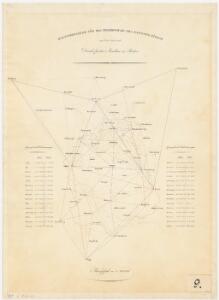
Eisenbahnprojecte der Schweizerischen Gesellschaft für Lokalbahnen
1 : 250000 1 Karte [Verlag nicht ermittelbar], [Erscheinungsort nicht ermittelbar]
Grosse Landtafel des Zürcher Gebiets: Esquelette der Zürcher Kantonskarte in 56 Blättern
Später eingefügte Blattübersicht von Johannes Müller. Müller, Johannes (1733-1816), obrigkeitlicher Ingenieur des Zürcher Stadtstaats, von Zürich
Carte de la Suisse avec les plans des cheflieux des 22 cantons
1 : 200000 1 Karte auf 8 Bl. dessinée et publié par Henri Keller ; Lithogr. von J. Schweizer = Charte der Schweiz mit den Grundrissen der Hauptorte der 22 Cantone Keller, Zürich