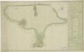
Maps of Smržov u Lomnice nad Lužnicí

Porostní mapa polesí Lomnice 1

Smrzow - c7096-1-004 - Kaiserpflichtexemplar der Landkarten des stabilen Katasters
1 : 2880
Smrzow - c7096-1-005 - Kaiserpflichtexemplar der Landkarten des stabilen Katasters
1 : 2880
Smrzow - c7096-1-002 - Kaiserpflichtexemplar der Landkarten des stabilen Katasters
1 : 2880
Smrzow - c7096-1-007 - Kaiserpflichtexemplar der Landkarten des stabilen Katasters
1 : 2880
Smrzow - c7096-1-001 - Kaiserpflichtexemplar der Landkarten des stabilen Katasters
1 : 2880
Smrzow - c7096-1-006 - Kaiserpflichtexemplar der Landkarten des stabilen Katasters
1 : 2880
Smrzow - c7096-1-003 - Kaiserpflichtexemplar der Landkarten des stabilen Katasters
1 : 2880
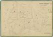
Porostní mapa polesí Dvořiště 1
1 : 10000
Hospodářská mapa polesí Lomnice 1
1 : 5780
Porostní mapa polesí Dvořiště 1
Hospodářská mapa polesí Lomnice 1
1 : 5780
Smržov o. Jindřichův Hradec 1
1 : 2880
Smržov o. Jindřichův Hradec 1
1 : 2880
Záblatí o. Jindřichův Hradec 1
1 : 2880
Mazelov o. České Budějovice 1
1 : 2380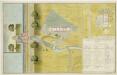
Půdorysný plán bošilecké bašty a myslivny u rybníka Dvořiště s přilehlými hospodářskými budovami 1

Zablat - c9004-1-005 - Kaiserpflichtexemplar der Landkarten des stabilen Katasters
1 : 2880
Zablat - c9004-1-004 - Kaiserpflichtexemplar der Landkarten des stabilen Katasters
1 : 2880
Zablat - c9004-1-002 - Kaiserpflichtexemplar der Landkarten des stabilen Katasters
1 : 2880
Zablat - c9004-1-001 - Kaiserpflichtexemplar der Landkarten des stabilen Katasters
1 : 2880
Zablat - c9004-1-003 - Kaiserpflichtexemplar der Landkarten des stabilen Katasters
1 : 2880
Zablat - c9004-1-006 - Kaiserpflichtexemplar der Landkarten des stabilen Katasters
1 : 2880
Smržov o. Jindřichův Hradec 1
1 : 2880
Mazalow - c4537-1-003 - Kaiserpflichtexemplar der Landkarten des stabilen Katasters
1 : 2880
Mazalow - c4537-1-001 - Kaiserpflichtexemplar der Landkarten des stabilen Katasters
1 : 2880
Mazalow - c4537-1-004 - Kaiserpflichtexemplar der Landkarten des stabilen Katasters
1 : 2880
Mazalow - c4537-1-005 - Kaiserpflichtexemplar der Landkarten des stabilen Katasters
1 : 2880
Mazalow - c4537-1-002 - Kaiserpflichtexemplar der Landkarten des stabilen Katasters
1 : 2880