Maps of Borkovice

Mapy činžovních pozemků I. sekce třeboňského velkostatku pro obce: Borkovice, Bošilec, Drahotěšice, Frahelž, Hamr, Horusice, Lhota, Líšnice, Mažice, Mezimostí, Ponědraž, Ponědrážka, Řípec, Val, Vlkov 1
1 : 2880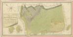
Geometrický plán dvora Borkovice s přilehlými pozemky 1
Záměrná mapa-brouillon-dvora Borkovice 1

Hospodářská mapa polesí Borkovice 1
1 : 2880
Hospodářská mapa polesí Borkovice 1
1 : 2880
Borkowitz - c0380-1-005 - Kaiserpflichtexemplar der Landkarten des stabilen Katasters
1 : 2880
Borkowitz - c0380-1-003 - Kaiserpflichtexemplar der Landkarten des stabilen Katasters
1 : 2880
Borkowitz - c0380-1-008 - Kaiserpflichtexemplar der Landkarten des stabilen Katasters
1 : 2880
Borkowitz - c0380-1-007 - Kaiserpflichtexemplar der Landkarten des stabilen Katasters
1 : 2880
Borkowitz - c0380-1-006 - Kaiserpflichtexemplar der Landkarten des stabilen Katasters
1 : 2880
Borkowitz - c0380-1-004 - Kaiserpflichtexemplar der Landkarten des stabilen Katasters
1 : 2880
Borkowitz - c0380-1-002 - Kaiserpflichtexemplar der Landkarten des stabilen Katasters
1 : 2880
Borkowitz - c0380-1-001 - Kaiserpflichtexemplar der Landkarten des stabilen Katasters
1 : 2880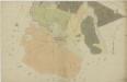
Borkovice o. Tábor 1
1 : 2880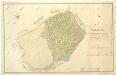
Geometrický plán odstoupených pozemků vsím Mažice, Zálší a Klečaty 1

Hospodářská mapa polesí Borkovice, list 3 1
1 : 2880
Geometrický plán borkovických blat 1

Maschitz - c4538-1-001 - Kaiserpflichtexemplar der Landkarten des stabilen Katasters
1 : 2880
Maschitz - c4538-1-005 - Kaiserpflichtexemplar der Landkarten des stabilen Katasters
1 : 2880
Maschitz - c4538-1-002 - Kaiserpflichtexemplar der Landkarten des stabilen Katasters
1 : 2880
Maschitz - c4538-1-003 - Kaiserpflichtexemplar der Landkarten des stabilen Katasters
1 : 2880
Maschitz - c4538-1-004 - Kaiserpflichtexemplar der Landkarten des stabilen Katasters
1 : 2880
Geometrický plán borkovických blat 1

Borkovice o. Tábor 1
1 : 2880
Přehledná mapa polesí Borkovice 1

Generální mapa panství Třeboň a inkorporovaných statků Bzí, Lomnice, Borovany, Třeboň, Hamr a Val 1
Administrativní mapa třeboňského panství se statky Bzí,Lomnice, Borovany,Hamr a Val 1

Přehledná mapa pozemků dvora Bzí 1

III. vojenské mapování 4353/2
1 : 25000


