Maps of Třebenice
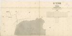
Katastrální mapa obce Sutom
1 : 2880
Suttom - c7573-1-001 - Kaiserpflichtexemplar der Landkarten des stabilen Katasters
1 : 2880
Suttom - c7573-1-002 - Kaiserpflichtexemplar der Landkarten des stabilen Katasters
1 : 2880
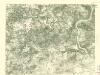
Boretz - c0366-1-002 - Kaiserpflichtexemplar der Landkarten des stabilen Katasters
1 : 2880
Boretz - c0366-1-001 - Kaiserpflichtexemplar der Landkarten des stabilen Katasters
1 : 2880
Boretz - c0366-1-003 - Kaiserpflichtexemplar der Landkarten des stabilen Katasters
1 : 2880
La bataille de Lowositz entre Sa Majesté le Roi de Prusse et le maréchal Broun le 1. octobre 1756
1 : 500 Lovosice-oblast (Česko) Thierbu Coentgen, Heinrich Hugo
Ebauché du combat qui s'est donné le 1. d'octobre. 1756. entre les troupes imp. et les Prussiens pres de Lobozitz en Boheme
Lovosice-oblast (Česko) Kotzii, Car. de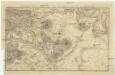
Plan der Gegend bey Lowositz in Böheim
Lovosice-oblast (Česko)
Topographischer Plan zwischen Trebnitz, Millischau und den Kletschen Berg
1 : 15000 Bílka (Bořislav, Česko) Marssovicky
[Kartenblatt]
1 : 25000 Lovosice (Česko : oblast) Reichsamt für Landesaufnahme
III. vojenské mapování 3752/3
1 : 25000
III. vojenské mapování 3752/3
1 : 25000
Bezirk Lobositz
1 : 72000 Lovosice-oblast (Česko) Josef Czerny
III. vojenské mapování 3752/3
1 : 25000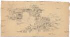
[České středohoří - západní část]
Most-oblast (Česko)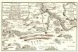
Lager der Kaÿserl. Königl. Ungarischen Armée beÿ Budin in Böhmen vor der Schlacht beÿ Lowositz Anno 1756
Mollova mapová sbírka Fridrich, Jacob Andreas Friedrich, Jacob Andreas
Touristen-Karte des Aussiger Mittel- und Erzgebirgs-Vereines
1 : 75000 Krušné hory (Česko a Německo) Kroitzsch, Carl Mittel- und Erzgebirgesverein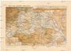
Mapa okres. hejtmanství Roudnického
1 : 100000 Budyně nad Ohří-oblast (Česko) R. Kaška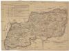
Karte der Bezirkshauptmannschaft zugleich Strafgerichtsbezirk Leitmeritz
1 : 222500 Litoměřice-oblast (Česko) von dem Lehrpersonale der Leitmeritzer k.k. Hauptschule
Litoměřice a okolí
1 : 75000 Litoměřice (Česko : oblast) Vojenský zeměpisný ústav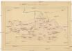
Okresní hejtmanství Roudnické
Roudnice nad Labem-oblast (Česko)
III. vojenské mapování 3752
1 : 75000
Soubor přehledných map pro plánování a statistiku: 3752 – Litoměřice

Geologische Uebersichtskarte von Teplitz, Bilin, Dux, Brüx un Umgegend
1 : 100000 Teplice-oblast (Česko) Marischler, Norbert Wolf, H. Adolf Becker
Ústí n. L. a Litoměřice
1 : 75000 Benešov nad Ploučnicí (Česko : oblast) Vojenský zeměpisný ústav
Bezirk Aussig

Aussig und Leitmeritz
1 : 75000 Litoměřice (Česko : oblast) Acham, Stefan K. u. k. militär-geographisches Institut
Aussig und Leitmeritz
1 : 75000 Litoměřice (Česko : oblast) Acham, Stefan K. u. k. Militärgeographisches Institut


