Maps of Havelaue

Meßtischblatt 3239 : Strodehne, 1950
1 : 250000 Strodehne. - Hrsg. 1882, Ausg. 1937. - 1:25000. - [S.l.] : Landesregierung Sachsen-Anhalt, Anstalt f. Kartogr., 1950. - 1 Kt.
Meßtischblatt 5535 : Lobenstein, [nach 1945]
1 : 250000 Lobenstein. - [Aufn. 1903, hrsg. 1905, ...]. - 1:25000. - [Berlin]: Reichsamt für Landesaufnahme, [nach 1945]. - 1 Kt.
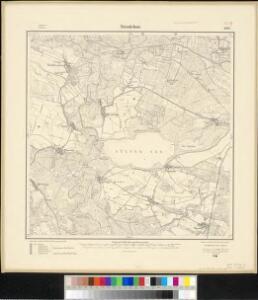
Meßtischblatt 1686 : Strodehne, 1911
1 : 250000 Strodehne. - Aufn. 1880, hrsg. 1882, einz. Nachtr. 1911. - 1:25000. - [Berlin]: Reichsamt für Landesaufnahme, 1911. - 1 Kt.
266. Stendal.
1 : 100000 Reichsamt fur Landesaufnahme
Composite: 241. Havelberg.
1 : 100000 Reichsamt fur Landesaufnahme
75. Stendal, uit: Topographische Uebersichtskarte des Deutschen Reiches / herausgegeben v. d. Kartogr. Abt. d. Königl. Preuß. Landesaufnahme
1 : 200000 titelvariant: Topogr. Übersichtskarte des Deutschen Reiches; Annotatie: Titel boven bladen ook: Topogr. Übersichtskarte des Deutschen Reiches; Annotatie geografische gegevens: Op elk blad twee maatstokken: 10 Kilometer = 5,5 cm; 1 geogr. Meile = 3,6 cm; Legenda onder op elk blad Königlich Preußische Landesaufnahme. Kartographische Abtheilung [S.l : Königlich Preußische Landesaufnahme, Kartographische Abtheilung]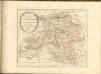

Wittenberge 46, uit: Special-Karte von Mittel-Europa / nach amtlichen Quellen bearbeitet von W. Liebenow
1 : 300000 titelvariant: W. Liebenow's Mittel-Europa; Annotatie: Titel boven de bladen: W. Liebenow's Mittel-Europa Johannes Wilhelm Liebenow 1822-1897 Frankfurt a. M. : Ludwig Ravenstein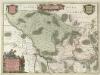
Marchionatvs Brandenburgici
1 : 330000 Mollova mapová sbírka Örnehufvud, Olof Hansson Covens, Johannes I
MARCHIONATUS | BRANDENBURGICI | PARS, quæ | MARCHIA VETUS, | Vulgo | ALTEMARCK, | dicitur.
[Amsterdam : Joan Blaeu]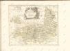

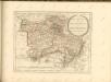
Magdebvrgensis Archiepiscopatvs
1 : 350000 Mollova mapová sbírka Blaeu, Joan Blaeu, Joan I.
MARCHIONATUS | BRANDENBURGICI | PARTES DUÆ, | RUPPIN | Comitatus | & | PRIGNITS | Regiuncula
Auct. Olao Iohannis Gotho, Gustavo Magno Cosm. [Amsterdam : Joan Blaeu]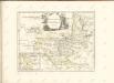

MAGDEBVRGENSIS | ARCHIEPISCOPATVS.
Amstelædami | J. Blaeu excudebat.
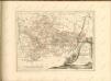
MARCH. BRANDENBURGICI | PARS, quæ | MARCHIA MEDIA | Vulgo MITTELMARCK audit.
Amstelædami, | Excud. Joannes Blaeu.
Geographische Charte des Hertzogthums und Halle Nebst etlichen angräntzende Orthen und Fürstenthume Gestochen
1 : 310000 Mollova mapová sbírka Schenk, Pieter Schenk, Peter II
Ducatus Magdeburgensis et Halensis cum finitimis Delineatio geographica curante
1 : 320000 Mollova mapová sbírka Seutter, Matthäus Lotter, Tobias Conrad Seutter, Matthäus
Das Hertzogthum Magdeburg mit seinen abgetheilten Provintzien
1 : 930000 Mollova mapová sbírka Weigel, Johann Christoph Weigel, Johann Christoph
[Berlin und Umgebung; Die Donau von Paussau bis Wien mit Umgebung]
Stieler's Hand-Atlas Stieler, Adolf bei Justus Perthes
Regierungsbezirk Magdeburg Kreiseinteilung 1820
Preußen, Magdeburg, Regierungsbezirk Kunz, Andreas ; Johnen, Bettina ; Moeschl, Joachim
Principatus Anhaldinus Et Magdeburgensis Archiepiscopatus. [Karte], in: Novus atlas absolutissimus, Bd. 2, S. 78.
1 Karte aus Atlas Janssonius Offizin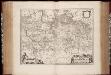
March. Brandenburgici pars, quae Marchia Media vulgo Mittelmarck audit
1 : 400000 Annotatie: Origineel is Blad 91 in atlas factice; Annotatie geografische gegevens: Met schaalstok: Milliaria Germanica Joan Blaeu 1597/98-1673 Amstelaedami : excud. Joannes Blaeu
Berlin - Leipzig - Wittenberge

Marchia Vetus, Vulgo Alte Marck in March: Brandenburgico. [Karte], in: Novus atlas absolutissimus, Bd. 2, S. 57.
1 Karte aus Atlas Janssonius Offizin
Map of that part of Hannover where the late battle between the Duke of Cumberland and Marshal D'Etrees was fought July 25, 26, 27
1 : 190080
Sect. 14: Berlin, uit: Geologische Karte des Deutschen Reichs in 27 Blaettern / [von] Richard Lepsius ; Red. von C. Vogel
1 : 500000 Annotatie: Blad 18 ontbreekt; Een aantal bladen op linnen; Een aantal bladen gereviseerd 1913-1914; Annotatie geografische gegevens: Met schaalstokken o.a. in kilometers; Legenda Carl Vogel 1828-1897 Gotha : Justus Perthes