Maps of Spreetal - Sprjewiny Doł

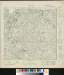
Meßtischblatt 4552 : Weißkollm, 1938
1 : 250000 Weißkollm. - Aufn. 1887, hrsg. 1889, bericht. 1937. - 1:25000. - [Berlin]: Reichsamt für Landesaufnahme, 1938. - 1 Kt.
Meßtischblatt 2620 : Weißkollm, 1922
1 : 250000 Weißkollm. - Hrsg. 1889, bericht. 1901, einz. Nachtr. 1922. - 1:25000. - [Berlin]: Reichsamt für Landesaufnahme, 1922. - 1 Kt.
Meßtischblatt 2620 : Weiß-Kollm, 1920
1 : 250000 Weiß-Kollm. - Aufn. 1887, Nachtr. 1920. - 1:25000. - [Berlin]: Reichsamt für Landesaufnahme, 1920. - 1 Kt.
Meßtischblatt 2620 : Weiss- Kollm, 1889
1 : 250000 Weiss- Kollm. - Aufnahme 1887. - 1:25000. - [Berlin]: Reichsamt für Landesaufnahme, 1889. - 1 Kt.
117. Görlitz, uit: Topographische Uebersichtskarte des Deutschen Reiches / herausgegeben v. d. Kartogr. Abt. d. Königl. Preuß. Landesaufnahme
1 : 200000 titelvariant: Topogr. Übersichtskarte des Deutschen Reiches; Annotatie: Titel boven bladen ook: Topogr. Übersichtskarte des Deutschen Reiches; Annotatie geografische gegevens: Op elk blad twee maatstokken: 10 Kilometer = 5,5 cm; 1 geogr. Meile = 3,6 cm; Legenda onder op elk blad Königlich Preußische Landesaufnahme. Kartographische Abtheilung [S.l : Königlich Preußische Landesaufnahme, Kartographische Abtheilung]
Geographische Verzeichnung des budissinischen Creises in dem Marggrafthum Ober Lausitz = Carte du cercle de Budissin dans le Marggrafiat de la Haute Lusace
1 : 280000 aus zuversichtlichen geodetischen Zeichnungen genommen und ans Licht gestellet von Homaennischen Erben [Nürnberg] : Homaennische Erben
Geographische Verzeichnung des Budissinischen Creises...

Geographische Verzeichnung des BVDISSINISCHEN CREISES in dem Marggrafthum OBER LAVSITZ
1 : 180000 Budyšín (Německo) von Homaennischen Erben
Geographische Verzeichnung des Bvdissinischen Creises in dem Marggrafthum Ober Lavsitz
1 : 185000 Budyšín (Německo) von Homaennischen Erben
Geographische Verzeichnung des Bvdissinischen Creises in dem Marggrafthum Ober Lavsitz
1 : 180000 Mollova mapová sbírka Homann, Johann Baptist Homann, Johann Baptista - dědici
Generální mapa ČSR

Generální mapa Protektorátu Čechy a Morava

Sbírka map a diagramů použitých na mírových konferencích v Paříži v letech 1919 - 1920

Cottbus 75, uit: Special-Karte von Mittel-Europa / nach amtlichen Quellen bearbeitet von W. Liebenow
1 : 300000 titelvariant: W. Liebenow's Mittel-Europa; Annotatie: Titel boven de bladen: W. Liebenow's Mittel-Europa Johannes Wilhelm Liebenow 1822-1897 Frankfurt a. M. : Ludwig Ravenstein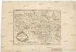
Die Markgrafschaft Oberlausitz in ihre Kreise eingetheilt.
1 : 363000 Horní Lužice (Německo) Hübner, Johann Homann, Johann Baptist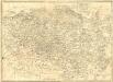
La Haute Lusace
1 : 180000 Mollova mapová sbírka Le Rouge, Georges-Louis Le Rouge, Georges-Louis
A map of the country round Dresden, with the towns and fortresses which the several armies have occupied during the campaign
1 : 475000
Ober Lausitz entworffen, und in Kupffer gestochen
1 : 230000 Mollova mapová sbírka Schreiber, Johann Georg Schreiber, Johann Georg
Lusatia Superior
1 : 260000 Mollova mapová sbírka Scultetus, Bartholomaeus Janssonius Van Waesberge, Johannes II
Lusatia Superior
1 : 260000 Mollova mapová sbírka Scultetus, Bartholomaeus Schenk, Peter I
Lusatia Superior
1 : 260000 Mollova mapová sbírka Funck, David Funck, David
Marchionatus Lusatiae Superioris

Marchionatus Lusatiae superioris felicissimo Poloniae regis, electoris Saxoniae, sceptro florens, dynastiis et praefecturis suis distributus nova accuratione
Horní Lužice (Německo) Seutter, Matthäus Lotter, Tobias Conrad Matth. Seutteri
Lusatia Superior
1 : 320000 Mollova mapová sbírka Weigel, Christoph Weigel, Christoph I.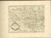

Lusatiae superioris tabula chorographica
1 : 215000 Horní Lužice (Německo) Schreiber, Johann Georg excusa studio Homannianorum Heredum
Lusatiae superioris tabula chorographica
1 : 215000 Horní Lužice (Německo) Schreiber, Johann Georg excusa studio Homannianorum Heredum
Marchionatus Lusatiae Superioris
1 : 180000 Mollova mapová sbírka Seutter, Matthäus Lotter, Tobias Conrad Seutter, Matthäus
LVSATIA | SVPERIOR
Authore | Barthol. Sculteto Gorlitio. [Amsterdam : Joan Blaeu]