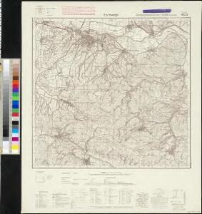
Maps of Weißenborn

Meßtischblatt 4826 : Eschwege, 1954
1 : 250000 Eschwege / redaktionelle Änderungen VD Thüringen. - Hrsg. 1909, letzte Nachtr. 1936. - 1:25000. - [Suhl]: VD, 1954. - 1 Kt.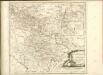

Tractvs Eichsfeldiae in suas Praefecturas divisae nec non Territorii Mvlhvsani Chorographia
1 : 160000 Mollova mapová sbírka Homann, Johann Baptist Homann, Johann Baptista - dědici
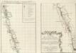
Eisenach 86, uit: [W. Liebenow's Special-Karte von Mittel-Europa]
1 : 300000 titelvariant: W. Liebenow's Mittel-Europa; Annotatie: Titel boven de bladen: W. Liebenow's Mittel-Europa Johannes Wilhelm Liebenow 1822-1897 Hannover : Hermann Oppermann
112. Cassel, uit: Topographische Uebersichtskarte des Deutschen Reiches / herausgegeben v. d. Kartogr. Abt. d. Königl. Preuß. Landesaufnahme
1 : 200000 titelvariant: Topogr. Übersichtskarte des Deutschen Reiches; Annotatie: Titel boven bladen ook: Topogr. Übersichtskarte des Deutschen Reiches; Annotatie geografische gegevens: Op elk blad twee maatstokken: 10 Kilometer = 5,5 cm; 1 geogr. Meile = 3,6 cm; Legenda onder op elk blad Königlich Preußische Landesaufnahme. Kartographische Abtheilung [S.l : Königlich Preußische Landesaufnahme, Kartographische Abtheilung]
Eisenach 86, uit: Special-Karte von Mittel-Europa / nach amtlichen Quellen bearbeitet von W. Liebenow
1 : 300000 titelvariant: W. Liebenow's Mittel-Europa; Annotatie: Titel boven de bladen: W. Liebenow's Mittel-Europa Johannes Wilhelm Liebenow 1822-1897 Frankfurt a. M. : Ludwig Ravenstein
Cassel
1 : 300000 R. Mittelbach
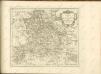
Principatus Isenacensis
1 : 210000 Mollova mapová sbírka Homann, Johann Baptist Homann, Johann Baptista
Tvringiae Noviss. descript.
1 : 520000 Mollova mapová sbírka Mellinger, Johann Plantin, Christoph (officina)
Herzogtum Sachsen-Coburg und Gotha 1830 Verwaltungsstruktur
Sachsen-Coburg-Gotha Verwaltung Kunz, Andreas ; Moeschl, Joachim Robert
Herzogtum Sachsen-Coburg und Gotha 1826 Verwaltungsstruktur
Sachsen-Coburg-Gotha Verwaltung Kunz, Andreas ; Moeschl, Joachim Robert
Herzogtum Sachsen-Coburg und Gotha 1834 Verwaltungsstruktur
Sachsen-Coburg-Gotha Verwaltung Kunz, Andreas ; Moeschl, Joachim Robert
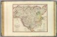
Principatus Isenacensis cum adjacentibus vicinorum statuum ditionibus exhibitus
1 : 190000 Durynsko (Německo) Homann, Johann Baptist J. B. Homann
Hassia Landgraviatus
1 : 350000 Mollova mapová sbírka Hondius, Henricus Janssonius, Johannes I
Holstein.
1 : 270000 Faden, William, 1750?-1836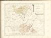
Inter Mayerianvm ad Mvsas Goettingenses
1 : 390000 Mollova mapová sbírka Mayer, Tobias Homann, Johann Baptista - dědici
Turingiae Noviss. Descript. [Karte], in: Theatrum orbis terrarum, S. 137.
1 Karte aus Atlas Ortelius, Abraham
Karte der Thüringer Eisenbahn
1 : 218000 Kunstanstalt von Mädel II
Thuringia lantgraviatus
1 : 395000 Durynsko (Německo) Hondius, Henricus Henricus Hondius
Turingiae Noviss. Descript. [Karte], in: Theatrum orbis terrarum, S. 229.
1 Karte aus Atlas Ortelius, Abraham Vrients, Jan Baptista
Illustrissimo principi Ioanni Georgio duci Saxoniae hanc Thuringiae lantgraviatus tabulam omni animi devotione
1 : 344000 Durynsko (Německo) Schenk, Pieter Petrus Schenk
THVRINGIA | LANDGRAVIATVS
Auct. Adolario Erichio | Anderslebiano. [Amsterdam : Joan Blaeu]
Landgraviatus Thuringiae juxta recentiss: designation in suos Principatus, Status et Praefecturas accuratissme divisus studio et impensis
1 : 350000 Mollova mapová sbírka Seutter, Matthäus Lotter, Tobias Conrad Seutter, Matthäus
Landgraviat. Thuringiae Tabula Generalis in suos Principatvs et Statvs accurate divi.
1 : 350000 Mollova mapová sbírka Homann, Johann Baptist Homann, Johann Baptista - dědici
Landgraviat Thuringiae Tabula Generalis in suos Principatvs et Statvs accurate divi.
1 : 350000 Mollova mapová sbírka Homann, Johann Baptist Homann, Johann Baptista
Großherzogtum Sachsen-Weimar-Eisenach 1820 Verwaltungsstruktur
Sachsen-Weimar-Eisenach Verwaltung Kunz, Andreas ; Moeschl, Joachim Robert