Maps of Nieciszów

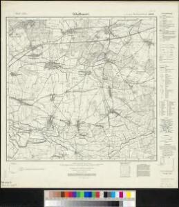
Meßtischblatt 2829 : Sibyllenort, 1932
1 : 250000 Sibyllenort. - Hrsg. 1887, bericht. 1926, einz. Nachtr. 1932. - 1:25000. - [Berlin]: Reichsamt für Landesaufnahme, 1932. - 1 Kt.
Wege - Karte der Gegend um Breslau

119. Breslau, uit: Topographische Uebersichtskarte des Deutschen Reiches / herausgegeben v. d. Kartogr. Abt. d. Königl. Preuß. Landesaufnahme
1 : 200000 titelvariant: Topogr. Übersichtskarte des Deutschen Reiches; Annotatie: Titel boven bladen ook: Topogr. Übersichtskarte des Deutschen Reiches; Annotatie geografische gegevens: Op elk blad twee maatstokken: 10 Kilometer = 5,5 cm; 1 geogr. Meile = 3,6 cm; Legenda onder op elk blad Königlich Preußische Landesaufnahme. Kartographische Abtheilung [S.l : Königlich Preußische Landesaufnahme, Kartographische Abtheilung]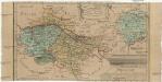
Das Fürstenthum Bresslau in Nieder-Schlesien
1 : 720000 Vratislav-oblast (Polsko) Schleuen, Johann David Schleuen
Das Fürstenthum Bresslau in Nieder-Schlesien
1 : 458300 Mollova mapová sbírka Schleuen, Johann David
Principtus Silesiae Wratislaviensis exactissima Tabula Geographica sistens simul Circulum Neoforensem et Districtum Cantiensem, ac status minores vulgo Burglehn dictos Lissa, Kraicka, Weigwitz, Rommenau, Krolkwitz, Bogenau, Malckwitz, Auras, Gr. Peterwitz et Halt Grosburg
1 : 120000 Mollova mapová sbírka Wieland, Johann Wolfgang Homann, Johann Christoph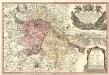
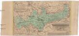
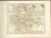
Principatus Silesiae Wratislaviensis :
1 : 120000 Mollova mapová sbírka Wieland, Johann Wolfgang Homann, Johann Baptista - dědici
Ducatus Breslanus sive Wratislaviensis
1 : 240000 Mollova mapová sbírka Aveele, Johannes van den Schenk, Peter I
Dvcatvs Breslanvs sive Wratislaviensis
1 : 220000 Mollova mapová sbírka Vechner, Georg Blaeu, Joan I.
Das Fürstenthum Brieg in Nieder-Schlesien
1 : 460000 Dolní Slezsko Schleuen, Johann David I.D. Schleuen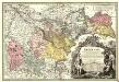
Principatvs Silesiae Bregensis
1 : 145000 Mollova mapová sbírka Wieland, Johann Wolfgang Homann, Johann Baptista - dědici
Principatvs Silesiae Oelsnensis :
1 : 154000 Mollova mapová sbírka Wieland, Johann Wolfgang Homann, Johann Baptista - dědici
Principatus Silesiae Wratislaviensis
1 : 129000 Vratislav-oblast (Polsko) Wieland, Johann Wolfgang Schubarth, Matthäus Haeredibus Homannianis
Principatus Silesiae Wratislaviensis
1 : 130000 Vratislav-oblast (Polsko) Wieland, Johann Wolfgang Schubarth, Matthäus ab Haeredibus Homannianis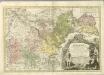

DVCATVS | BRESLANVS | sive | WRATISLAVIENSIS
Amstelædami, Apud Joan. Blaeu

Principatvs Silesiae Oelsnensis in suos districtus Oels Bernstadt et Trebnitz divisi exactissima tabula geographica, exhibens insimul circumjacentes dynastias liberas Trachenberg et Militsch, cum statibus minoribus Freyhain Nevschlos, Goschvtz et Zvlavf
1 : 154000 Oleśnica (Vratislav, Polsko) Wieland, Johann Wolfgang Schubarth, Matthäus Haeretibus Homannianis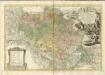

Breslau 77, uit: Special-Karte von Mittel-Europa / nach amtlichen Quellen bearbeitet von W. Liebenow
1 : 300000 titelvariant: W. Liebenow's Mittel-Europa; Annotatie: Titel boven de bladen: W. Liebenow's Mittel-Europa Johannes Wilhelm Liebenow 1822-1897 Frankfurt a. M. : Ludwig Ravenstein
Ducatus Breslanus sive Wratislaviensis. [Karte] Breslaw totius Silesiae Metropolis. [Nebenkarte], in: Novus atlas absolutissimus, Bd. 2, S. 264.
1 Karte aus Atlas Janssonius Offizin

Prov. Schlesien Reg. Bez
1 : 180000 Varšava-oblast (Polsko)
Karte des Sudeten zum Gebrauch für Reisende
1 : 500000 Krkonoše (Česko a Polsko) Schweitzer Gumprecht, A. A. Gumprecht
[Dvcatvs Silesiae tabvla altera Svperiorem Silesiam]
Horní Slezsko Hase, Johann Matthias ar les Heritie[rs de Homann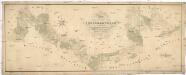
Situations Plan der trokenen Landesgraenze zwischen dem Weichsel und Pietruvka Flus von kais. koen. Oesterreich. Schlesien und koen. Preussisch Schlesien
1 : 10000 Visla-oblast (Polsko) Kuffay, Franz Engel
Sect. 21: Breslau, uit: Geologische Karte des Deutschen Reichs in 27 Blaettern / [von] Richard Lepsius ; Red. von C. Vogel
1 : 500000 Annotatie: Blad 18 ontbreekt; Een aantal bladen op linnen; Een aantal bladen gereviseerd 1913-1914; Annotatie geografische gegevens: Met schaalstokken o.a. in kilometers; Legenda Carl Vogel 1828-1897 Gotha : Justus Perthes