Maps of Lontzen

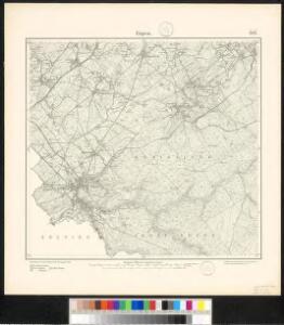
Meßtischblatt 3091 : Eupen, 1895
1 : 250000 Eupen. - Aufn. 1893. - 1:25000. - [Berlin]: Kgl. Preuss. Landesaufnahme, 1895. - 1 Kt.
Plan parcellaire de la commune de Membach : avec les mutations
1 : 10000 Royal Library of Belgium Map Room Popp, Philippe Christian (1805-1879) Popp, Philippe Christian (1805-1879)
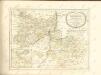
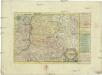
Tabula ducatus Limburch et comitatus Valckenburch
1 : 115000 Limbursko Wit, Frederick de by Frederick de Wit
Plan parcellaire de la commune de Baelen lez-Limbourg : avec les mutations
1 : 5000 Royal Library of Belgium Map Room Popp, Philippe Christian (1805-1879) Popp, Philippe Christian (1805-1879)
Carte du Marquisat de Franchimont
1 : 140000 H. Godin sculp. [S.l.] : [s.n.]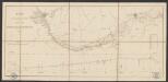
Plan du chemin de fer compris entre Liège et Aix-la-Chapelle
1 : 100000 Etablissement géographique
De klassis van Maastricht en landen van Overmaas
1 : 180000 door W.A. Bachiene ... J. van Jagen sculp. 1768. te Amsterdam : by D. onder de Linden
LIMBURGI Ducatus et Comitatus Nova Descriptio
1 : 110000 Limburg (Belgie : provincie) Visscher, Nicolaus per N. Visscher
Dvcatvs Limbvrgvm
1 : 180000 Mollova mapová sbírka Martini, Aegidius Schenk, Peter I
Dvcatvs Limbvrgvm
1 : 266000 Mollova mapová sbírka Merian, Matthaeus Merian, Matthäus
Dvcatvs Limbvrgvm
1 : 180000 Mollova mapová sbírka Martini, Aegidius Blaeu, Joan I.
Dvcatvs Limbvrgvm
1 : 175000 Mollova mapová sbírka Martini, Aegidius
Tabula Ducatus Limburch, et Comitatus Valckenburch
1 : 125000 in lucem edita a F. De Wit. Amsterdam : by I. Cóvens en C. Mortier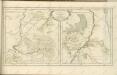
Das Herzogthum Limburg
1 : 380000 Limbursko Schreiber, Johann Georg bey Joh. Georg. Schreibern
XIV ; 3.L., uit: Carte chorographique des Pays-Bas Autrichiens / ... par le Comte de Ferraris ; gravée par L.A. Dupuis
1 : 86400 Annotatie: Bladen linksboven genummerd met Romeinse cijfers, rechtsboven met een cijfer en een letter; Met opdracht aan keizer Joseph II (bl.XVI); Met plattegrond van Brussel (bl. XXI), overzichtskaart (bl. XXII) en bladwijzer (bl. XXIII); Annotatie geografische gegevens: Schaalstokken: Echelle de Toises ou de Lieues communes de France; Echelle de Verges ou de Lieues de Brabant; Echelle de Milles d'Allemagne (bl. XVII); Echelle de Mètres; In de hoeken lengte- en breedtematen T.M.e en T.P.e Joseph-Jean François Ferraris Comte de 1726-1814; L.A. Dupuis [S.l. : s.n.]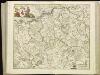
[114][117] Tabula Ducatus Limburch. et Comitatus Valckenburgh., uit: Atlas sive Descriptio terrarum orbis
Annotatie: Gedigitaliseerde versie. Amsterdam. Heiloo : Picturae (vervaardiger), 2015. tiff-bestand. Gedigitaliseerd: 07-01-2015; Origineel: Universiteitsbibliotheek Vrije Universiteit (XL.05127.-) ; Netherlands; Titelpagina ontbreekt Wit, Frederik de Amsterdam : Frederick de Wit
122. Aachen, uit: Topographische Uebersichtskarte des Deutschen Reiches / herausgegeben v. d. Kartogr. Abt. d. Königl. Preuß. Landesaufnahme
1 : 200000 titelvariant: Topogr. Übersichtskarte des Deutschen Reiches; Annotatie: Titel boven bladen ook: Topogr. Übersichtskarte des Deutschen Reiches; Annotatie geografische gegevens: Op elk blad twee maatstokken: 10 Kilometer = 5,5 cm; 1 geogr. Meile = 3,6 cm; Legenda onder op elk blad Königlich Preußische Landesaufnahme. Kartographische Abtheilung [S.l : Königlich Preußische Landesaufnahme, Kartographische Abtheilung]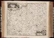
Limburgi Ducatus et Comitatus Valckenburgi nova descriptio / per N. Visscher
1 : 110000 Annotatie: Origineel is Blad 38 in atlas factice; Annotatie geografische gegevens: Noordwest boven; Met 2 schaalstokken Nicolaes Jansz Visscher sr 1618-1679 [Amsterdam : N. Visscher]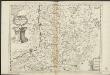
Ducea di Limburgo
1 : 200000 [Vincenzo Coronelli] [S.l.] : [s.n.]
Limburgi Ducatus et Comitatus Valckenburgi Nova Descriptio [Karte], in: Novus atlas absolutissimus, Bd. 3, S. 70.
1 Karte aus Atlas Janssonius Offizin

Leodiensis Episcopatus
1 : 130000 Mollova mapová sbírka Visscher, Nicolaes Schenk, Peter I
Limburgensis ducatus nova descriptio
1 : 220000 Limbursko Martini, Aegidius Visscher, Nicolaus CI Visscher
XIV, uit: Carte chorographique des Pays-Bas Autrichiens / ... par le Comte de Ferraris ; gravée par L.A. Dupuis
1 : 86400 Annotatie: Lit.: Les militaires et la cartographie des Pays-Bas méridionaux et de la Principauté de Liège à la fin du XVIIe et au XVIII siècle / Claire Lemoine-Isabeau. - Bruxelles, 1984, p. 206-212; La cartographie au XVIIIe siècle et l'oeuvre du Comte de Ferraris (1726-1814) : colloque international, Spa, 8-11 sept. 1976. - Bruxelles, 1978; Met opdracht aan keizer Joseph II (bl.XVI); Met plattegrond van Brussel (bl. XXI), overzichtskaart (bl. XXII) en bladwijzer (bl. XXIII); Ontbreekt: bl. I-III en XXI; Voor aanwezige bladen zie overzichtsblad Ferraris, Johann Joseph; Dupuis, L. A. [S.l. : s.n.]

DVCATVS | LIMBVRGVM
Auctore | ÆGIDIO MARTINI. Amsterdami | Apud Guiljelmum et Joannem Blaeu
DVCATVS | LIMBVRGVM
Auctore | ÆGIDIO MARTINI. Amsterdami | Apud Guiljelmum et Joannem Blaeu