Maps of Faulquemont

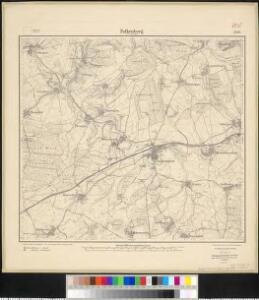
Meßtischblatt 3565 : Falkenberg in Lothringen, 1916
1 : 250000 Falkenberg in Lothringen. - Aufn. 1881, hrsg. 1883, Aufldr. 1916. - 1:25000. - [Berlin]: Reichsamt für Landesaufnahme, 1916. - 1 Kt.
[Metz]
1 Blatt : 60 x 91 cm s.n.
141 Metz.
1 : 86400 Cassini family; Cassini, Cesar-Francois, 1714-1784
Le Flambeau de la Guerre Allumee au Rhin
Mollova mapová sbírka Delisle, Guillaume Schenk, Peter II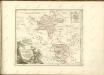
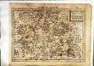
Le pays Messin, partie du temporel de l'evesché de Metz et partie du balliage allemand, dans le duché de Lorraine
1 Karte : Kupferdruck ; 44 x 68 cm Jaillot Alexis-Hubert Jaillot
Lotharingia Septentrionalis Loraine vers le Seption.
1 : 330000 Mollova mapová sbírka Valk, Gerhard Schenk, Peter I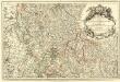
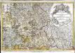
Les Estats du Duc de Lorraine ou sont les Duchez de Lorraine et de Bar :
1 : 180000 Mollova mapová sbírka Jaillot, Alexis-Hubert Jaillot, Alexis Hubert
Mediomatrici
1 Karte : Kupferdruck ; 43 x 50 cm Sanson chez l'auteur
Nancy 126, uit: [W. Liebenow's Special-Karte von Mittel-Europa]
1 : 300000 titelvariant: W. Liebenow's Mittel-Europa; Annotatie: Titel boven de bladen: W. Liebenow's Mittel-Europa Johannes Wilhelm Liebenow 1822-1897 Hannover : Hermann Oppermann
Archid.conné de Sarbovrg dans l'Evesché de Metz
1 : 240000 Mollova mapová sbírka Sanson, Nicolas Mariette, Pierre Sanson, Nicolas
Mediomatrici
1 Karte : Kupferdruck ; 41 x 48 cm Sanson; Mariette chez P. Mariette
Nancy 126, uit: Special-Karte von Mittel-Europa / nach amtlichen Quellen bearbeitet von W. Liebenow
1 : 300000 titelvariant: W. Liebenow's Mittel-Europa; Annotatie: Titel boven de bladen: W. Liebenow's Mittel-Europa Johannes Wilhelm Liebenow 1822-1897 Frankfurt a. M. : Ludwig Ravenstein
Mediomatrici
1 Karte : Kupferdruck ; 41 x 48 cm Sanson; Robert de Vaugondy ches le Sr. Robert geog. du roi quai de l'horloge
Nova & Accurata delineatio geographica | EPISCOPATUS METENSIS | Quo ad Iurisdictionem temporalem
[Amsterdam : Joan Blaeu]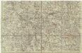
[Lotrinsko a Sársko]
Lotrinsko (Francie) Buna, Wilhelm C.
Le Theatre de Bellone :
Mollova mapová sbírka Schenk, Pieter Braakman, Adriaan
Carte topographique d'Allemagne
1 : 224000 Falc Rýnská Jaeger, Johann Wilhelm Abraham I. W. A. Iaeger
Mediomatrici
1 Karte : Kupferdruck ; 44 x 51 cm Sanson; Robert de Vaugondy chez l'auteur, chés le Sr. Robert geog. ord. du roi quai de l'horloge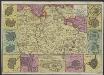
Carte du Duché de Lorraine, gravée sur les derniers memoires
1 : 600000 [Amsterdam] : [De La Feuille?]
[Atlas départemental : La France et ses colonies] No. 53 Meurthe
1 : 670000 publ. par Michel fils ainé [dressé par A. Lorrain, et gravé par H. Dandeleux] Versailles [etc.] : Barreswil et Andrieux
Département de la Meurte
1 Karte : Kupferdruck ; 48 x 48 cm Houdan au bureau de l'atlas national rue de la Harpe no. 26, et au dépôt du dit atlas rue de la Monnoye no. 5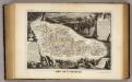
Dept. De La Moselle.
1 : 455000 Levasseur, Victor.
Lotharingia septentrionalis
1 Karte : Kupferdruck ; 36 x 47 cm Janssonius Joannes Janssonius
Lotharingiæ dvcatvs svperioris vera delineatio
1 Karte : Kupferdruck ; 20 x 28 cm Quad; Bussemacher excudit Iohannes Bussemacher
[Atlas départemental : La France et ses colonies] No. 56 Moselle
1 : 670000 publ. par Michel fils ainé [dressé par A. Lorrain, et gravé par H. Dandeleux] Versailles [etc.] : Barreswil et Andrieux
Übersichtskarte für den 15ten August Abends
1 : 200000 Francie Kgl. Hofbuchh. v. E.S. Mittler Sohn
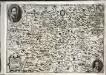
Mediomatrici Archidiacnés. de Metz, de Vic, et de Marsal, Dans l'Evesché de Metz ou sont parties du Temporel de l'Evesché et le Ballge de Metz du Marqsat. de Pont a Mouson &c.
1 : 240000 Mollova mapová sbírka Sanson, Nicolas Mariette, Pierre Sanson, Nicolas