Maps of Superior Upland
Shell Highway Map of Wisconsin (southern portion).
1 : 950400 Shell Oil Company
Lake Superior and the Northern Part of Michigan.
1 : 1309000 Colton, G. Woolworth
Northern Michigan and Lake Superior.
1 : 1500000 Colton, G.W.
Northern Michigan and Lake Superior.
1 : 2100000 Rand McNally and Company
Wisconsin.
1 : 1900000 Tanner, Henry S.
Wisconsin.
1 : 1600440 Colton, G.W.
Lake Superior and the Northern Part of Michigan.
1 : 1600000 Colton, G.W.
Wisconsin.
1 : 2000000 Colton, G.W.
Lake Superior and Upper Peninsula of Michigan.
1 : 1100000 Colton, G.W.
Lake Superior and the Northern Part of Michigan.
1 : 1600000 Colton, G.W.
Wisconsin.
1 : 1647360 Colton, G.W.
Northern Michigan and Lake Superior.
1 : 1500000 Colton, G.W.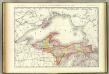
Northern Michigan.
1 : 1030000 Rand McNally and Company
Northern Michigan and Lake Superior.
1 : 1500000 Colton, G.W.
Wisconsin.
1 : 1340000 Tanner, Henry S.
Lake Superior And The Northern Part Of Michigan.
1 : 1625000 Colton, G.W.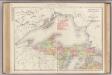
Michigan, Northern Peninsula.
1 : 1014000 Rand McNally and Company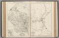
Wisconsin. Milwaukee.
Rand McNally and Company
Wisconsin.
1 : 1651000 Colton, G. Woolworth
Wisconsin.
1 : 3000000 Colton, G.W.
Wisconsin.
1 : 2000000 Colton, G.W.
Wisconsin
Map of Wisconsin with drawings illustrating historic places and events throughout the state. The Great Seal of the State of Wisconsin appears at the top right and the flags of Spain (1600), France (1700), England (1794), and a U.S. flag (1805) appear at left. There is a key explaining all 104 drawings at the bottom of the map. Kishner, Mel Wisconsin Tales and Trails, Inc.
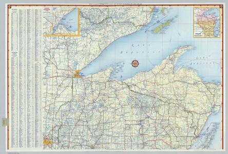
Preliminary traffic map, showing annual 24 hour average traffic, state of Wisconsin
1 : 1198000 This blue line print map shows highways, the scale of traffic volume, and average 24 hour traffic. Also included are inset maps of Appleton, Neenah, and Menasha, Waukesha County, Milwaukee County, Racine County, Kenosha County, Washington County, and Ozaukee County. Wisconsin. State Highway Commission Wisconsin. State Highway Commission
Historical map of Wisconsin
Pictorial map showing historical events and locations within the state of Wisconsin, as well as waterways and counties. Original caption on the bottom margin reads:"Published by the Milwaukee Sentinel commemorating its one hundredth anniversary June 27, 1937. Approved by the Wisconsin Conservation Commission. Checked and approved by Dr. Joseph Shafer, superintendent of the Historical Society of Wisconsin, and Dr. Louise Phelps Kellogg, senior research associate. Endorsed by the Wisconsin State Chamber of Commerce. Litho. in U.S.A." Bohlman, Nina S. Milwaukee Map Service Inc.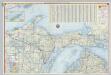
Shell Highway Map of Michigan (northern portion).
1 : 887040 Shell Oil Company
Educational map of the state of Wisconsin
1 : 380160 This map is ink on paper and shows the location of various types of schools. The map includes text about the school system and tables of statistics (1849-1875) including: Number of children-attendance -- Apportionment of state money -- School houses -- Annual expenses -- Teachers and certificates -- Teachers' wages -- Territorial divisions -- Statistics for 1875 -- Statistics of cities. The map also includes illustrations of: River Falls Normal School -- Oshkosh Normal School -- Platteville Normal School -- University of Wisconsin (Ladies Hall, S. Dormitory, University Hall, N. Dormitory) -- Science Hall (University of Wisconsin) -- Whitewater Normal School. Searing, Edward
A Geological Map of Wisconsin
1 : 1710720 This map shows counties, cities, rivers, canals, lakes, railroads, common roads, county towns, townships, villages, and post offices. The map includes part of the upper peninsula of Michigan. Lapham, Increase Allen
Map of Lincoln County.
1 : 380160 Snyder, Van Vechten & Co.
Hancock
1 : 250000
Hancock
1 : 250000