Maps of Полесск

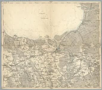
Composite: 30. Labiau. (Germany)
1 : 100000 Reichsamt fur Landesaufnahme
Meßtischblatt 1192 : Labiau, 1938
1 : 250000 Labiau. - Hrsg. 1913, bericht. 1922, einz. Nachtr. 1937, r. - 1:25000. - [Berlin]: Reichsamt für Landesaufnahme, 1938. - 1 Kt.
Meßtischblatt 1191 : Lablacken, 1938
1 : 250000 Lablacken. - Hrsg. 1913, bericht. 1922, redakt. Änd. 1938. - 1:25000. - [Berlin]: Reichsamt für Landesaufnahme, 1938. - 1 Kt.
Meßtischblatt 1193 : Laukischken, 1928
1 : 250000 Laukischken. - Hrsg. 1913, bericht. 1922, einz. Nachtr. 1928. - 1:25000. - [Berlin]: Reichsamt für Landesaufnahme, 1928. - 1 Kt.
Messtischblatt 1092 : Rinderort, 1938 Rinderort
1 : 250000 Rinderort. - Hrsg. 1912, bericht. 1922, redakt. Änd.1938.. - 1:25000. - [Berlin]: Reichsamt für Landesaufnahme, 1938. - 1 Kt.
Messtischblatt 1091 : Postnicken, 1922 Postnicken (Ost)
1 : 250000 Postnicken (Ost). - Hrsg. 1912, bericht. 1922. - 1:25000. - [Berlin]: Reichsamt für Landesaufnahme, 1922. - 1 Kt.
Messtischblatt 111 : Nemonien, 1925 Nemonien
1 : 250000 Nemonien. - Hrsg. 1911, bericht. 1922. - 1:25000. - [Berlin]: Reichsamt für Landesaufnahme, 1922. - 1 Kt.
Meßtischblatt 1293 : Alt Gertlauken, 1938
1 : 250000 Alt Gertlauken. - Hrsg. 1913, bericht. 1922, einz. Nachtr. 1928, r. - 1:25000. - [Berlin]: Reichsamt für Landesaufnahme, 1938. - 1 Kt.
Meßtischblatt 1292 : Goldbach, 1938
1 : 250000 Goldbach. - Hrsg. 1914, bericht. 1922, einz. Nachtr. 1928, r. - 1:25000. - [Berlin]: Reichsamt für Landesaufnahme, 1938. - 1 Kt.
Meßtischblatt 1291 : Kaimen, 1942
1 : 250000 Kaimen. - Aufn. 1911, Hrsg. 1914, bericht. 1922, letzte Na. - 1:25000. - [Berlin]: Reichsamt für Landesaufnahme, 1942. - 1 Kt.
30. Labiau. (Germany)
1 : 100000 Reichsamt fur Landesaufnahme
Sect. 7. Labiau (Ost-Samland), uit: Geologische Karte der Provinz Preussen
1 : 100000 Annotatie: Incompleet; Voor aanwezige bladen zie bladoverzicht; Met inzetkaarten; Annotatie geografische gegevens: Coördinaten gebaseerd op nulmeridiaan van Ferro (Hierro) Berlin : Neumann

Insterburg u. Gumbinnen 18, uit: Special-Karte von Mittel-Europa / nach amtlichen Quellen bearbeitet von W. Liebenow
1 : 300000 titelvariant: W. Liebenow's Mittel-Europa; Annotatie: Titel boven de bladen: W. Liebenow's Mittel-Europa Johannes Wilhelm Liebenow 1822-1897 Frankfurt a. M. : Ludwig Ravenstein
Die Kurische Nehrung und ihre Umgebung
1 : 300000 Russland Litauen Kurische Nehrung Bezzenberger, Adalbert
Sect. 8. Insterburg (Nadrauen), uit: Geologische Karte der Provinz Preussen
1 : 100000 Annotatie: Incompleet; Voor aanwezige bladen zie bladoverzicht; Met inzetkaarten; Annotatie geografische gegevens: Coördinaten gebaseerd op nulmeridiaan van Ferro (Hierro) Berlin : Neumann
Composite: 29. Cranz. (Germany)
1 : 100000 Reichsamt fur Landesaufnahme
16. Rossitten. (Germany)
1 : 100000 Reichsamt fur Landesaufnahme
Composite: 16. Rossitten. (Germany)
1 : 100000 Reichsamt fur Landesaufnahme
Meßtischblatt 0993 : Gilge, 1937
1 : 250000 Gilge. - Hrsg. 1913, einzl. Nachtr. 1937. - 1:25000. - [Berlin]: Reichsamt für Landesaufnahme, 1937. - 1 Kt.
Messtischblatt 112 : Lauknen, 1922 Lauknen
1 : 250000 Lauknen. - Hrsg. 1914, kl. Nachtr. 1922. - 1:25000. - [Berlin]: Reichsamt für Landesaufnahme, 1922. - 1 Kt.
Meßtischblatt 1194 : Eichenrode (Ostpr.), 1928
1 : 250000 Eichenrode (Ostpr.). - Hrsg. 1914, einz. Nachtr. 1928. - 1:25000. - [Berlin]: Reichsamt für Landesaufnahme, 1928. - 1 Kt.
Regni Borussiae Episcopatus Warmiensis Palatinatus Mariaeburgensis et Culmensis cum Territorio Dantiscano et Ichnographia Urbis Regiomontis].
Mollova mapová sbírka
Sect. 5: Königsberg, uit: Geologische Karte des Deutschen Reichs in 27 Blaettern / [von] Richard Lepsius ; Red. von C. Vogel
1 : 500000 Annotatie: Blad 18 ontbreekt; Een aantal bladen op linnen; Een aantal bladen gereviseerd 1913-1914; Annotatie geografische gegevens: Met schaalstokken o.a. in kilometers; Legenda Carl Vogel 1828-1897 Gotha : Justus Perthes
Provinz Ostpreussen
1 : 1250000 Ostpreußen
Litauisch und Masurisch
Ostpreußen Litauisch, Masurisch
Prvssia
1 Karte : Kupferdruck ; 35 x 47 cm Mercator; Hondius Henricus Hondius
Ost-Preussen.
1 : 935000 Flemming, Carl