Maps of Pará

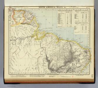
South America 2.
1 : 6969600 Letts, Son & Co.
Guayana, N. Brazil.
1 : 6760000 Society for the Diffusion of Useful Knowledge (Great Britain)
Brasil N.E. et Guyanes.
1 : 6000000 Vivien St Martin, L.
Brésil et pays des Amazones
1 : 10700000 Amazonka-oblast Bonne, Rigobert André
Eastern Brazil.
1 : 8400000 Sharpe, J.
Brazil, Paraguay, and Uruguay (northern half).
1 : 5020000 Rand McNally and Company
[Süd-Amerika in 6 Blättern, Blatt 2]
Adolf Stieler's Handatlas über alle Theile der Erde und über das Weltgebäude Stieler, Adolf Justus Perthes
South America 1.
1 : 2800000 Arrowsmith, Aaron
Karte vom Amazonen Strome
Amazonka-oblast Martius, C. von Schwarzmann, I.
Facsimile: Guiana by Hartsinck.
1 : 7700000 Hartsinck, J.J.
Partie du Bresil. Amer. Merid. 11.
1 : 1641836 Vandermaelen, Philippe, 1795-1869
Guyanes. Amer. Merid. 7.
1 : 1641836 Vandermaelen, Philippe, 1795-1869
Partie du Bresil. Amer. Merid. 12.
1 : 1641836 Vandermaelen, Philippe, 1795-1869
Partie du Bresil. Amer. Merid. 17.
1 : 1641836 Vandermaelen, Philippe, 1795-1869
Partie du Bresil. Amer. Merid. 18.
1 : 1641836 Vandermaelen, Philippe, 1795-1869
Guyane Française
Vidal de La Blache, Paul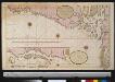
Een gedeelte van de kust van Brasilia tussen Cabo Noord en Cabo de Cuma
Brazil Gerard van Keulen
Guyanes.
1 : 3100000 Buchon, J. A. C.; Carey, H. C.; Lea, I.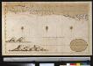
Een gedeelte van Brazilia tussen Cabo de Cuma en Bahia Baxa
Brazil Gerard van Keulen
Carte des colonies Française et Hollandaise de la Guyane
1 : 2923974 Mentelle, E. (Edme), 1730-1815 P.G. Chanlaire, Rue Geoffoy-Langevin, No. 328 ; et. E. Mentelle, Galerie du Museum No. 19
Partie du Bresil. Amer. Merid. 13.
1 : 1641836 Vandermaelen, Philippe, 1795-1869
Partie du Bresil. Amer. Merid. 19.
1 : 1641836 Vandermaelen, Philippe, 1795-1869
Carte de St. Domingue
1 : 2500000 Herbin de Halle, Etienne de.
Een gedeelte van de kust van Brazilia tussen Cabo de Cuma en Bahia Baxa
Brazil Gerard van Keulen
PRÆFECTURA | DE CIRÎIÎ, | vel SEREGIPPE DEL REY cum | Itàpuáma.
[Amsterdam : Joan Blaeu]
Land-kaart van het eiland en de volksplanting van Cayenne aan de kust van Zuid-Amerika
1 : 150000 [Amsterdam : Isaak Tirion]
PRÆFECTURÆ | PARANAMBUCÆ | PARS | MERIDIONALIS
[Amsterdam : Joan Blaeu]
Kaart van Suriname / naar de opmetingen van J.F.A. Cateau van Rosevelt en J.F.A.E. van Lansberge ; aangevuld tot 1898 met die van, en geteekend door W.L. Loth
1 : 500000 Cateau van Rosevelt, J. F. A.; Lansberge, J. F. A. E. van; Loth, W. L. Amsterdam : De Bussy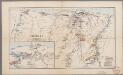
Suriname
1 : 1040000 Annotatie: Uit: Neuer Handatlas ... / E. Debes. - Leipzig, 1893-; Ook verschenen in: Ons Suriname / H. Weiss. - Utrecht, 1911 Leipzig : Wagner & Debes