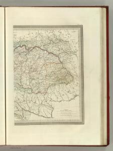
Maps of Carpathian Mountains

Carte Generale l'Empire d'Autriche.
1 : 2700000 Vivien de St Martin, L.
A new [and] accurate map of Moscovy, or Russia in Europe, with its aquisitions / by Eman.l Bowen
1 : 2300000 1 Karte : Kupferdruck ; 31 x 21 cm Bowen, Emanuel [Verlag nicht ermittelbar]
Mappa Królestwa Polskiego / ułożona na zasadzie źródeł urzędowych prez M. Nipanicza
1 : 735000 1 Karte : Lithografie, koloriert ; 126 x 99 cm Nipanicz, Mikołaj [Verlag nicht ermittelbar]
Beschreibung aller laender so etwan dem künigreich Poland underworffen seind gewesen, oder sunst mi
1 : 7500000 1 Karte : Holzschnitt ; 10 x 14 cm Münster, Sebastian [Henricpetri]
Russia in Europe / the map drawn & engraved by J. Rapkin ; the illustrations by A.H. Wray & engraved
1 : 15206400 1 Karte : Lithographie ; 29 x 22 cm Wray, A.H. J. & F. Tallis
Austria & Hungary (eastern sheet).
1 : 1642000 Johnston, W. & A.K.
Russia in Europe / drawn & engraved by J. Dower ...
1 : 15000000 1 Karte : Lithogr. (mehrfarb.) ; 25 x 20 cm Dower, John Orr & Smith
Russland. I. Das europaeische Russland, II. Das Königreich Polen, III. Die Republik Krakau
1 : 2500000 1 Karte : Lithographie ; 27 x 20 cm Schlieben, W.E.A. von [Georg Joachim Göschen]
Totius imperii Russici tabula generalis / ex optimis quibusvis Academiae Petropolit. mappis, quarum
1 : 7300000 1 Karte auf 3 Blatt : Kupferdruck ; 56 x 129 cm ; Einzelbl. 56 x 43 cm Büsching, Anton Friedrich [Verlag nicht ermittelbar]
Karta evropejskoj Rossii i Sibiri / sostavlena po novejšim statističeskim i geografičeskim svěd
1 : 3000000 1 Karte : einfarbig, Grenzen koloriert ; 133 x 99 cm Ševelev, A. v Geografičeskom Magazině Glavnago Štaba
The Russian empire from the best authorities / by Thos. Kitchin Geographer
1 : 31700000 1 Karte : Kupferdruck ; 18 x 27 cm Kitchin, Thomas [S. Crowder]
Austria E.
1 : 1642000 Johnston, Alexander Keith, 1804-1871
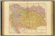
Austro-Hungarian Monarchy (eastern sheet).
1 : 1642000 Johnston, Alexander Keith
OCTAVA EUROPE TABULA / [Kartograph: Nicolaus Germanus ; Stecher: Johannes von Armsheim]
1 : 5100000 1 Karte : Holzschnitt ; 40 x 57 cm Ptolemaeus, Claudius [Johann Reger?]
Galizien, Ungarn, Slavonien, Kroatien, Siebenburgen, Dalmatien, Moldau, Wallachey.
1 : 10000000 Brudin, J. L.; Stieler, Adolf
Moscovie ou Russie / [Robert Morden]
1 : 25700000 1 Karte : Kupferdruck ; 9 x 11 cm (ganze Seite: 20 x 16 cm) Morden, Robert [Verlag nicht ermittelbar]
Carte Geographique du Theatre de la Guerre en General representant le Royaume de Hongarie
1 : 1300000 Mollova mapová sbírka Lotter, Tobias Conrad Lotter, Tobias Conrad
Heerstrasse von Constantinopel nach Nissa
Balkánský poloostrov
Russia or Moscovy with its acquisitions etc. in Sweden / by H. Moll Geographer
1 : 13000000 1 Karte : Kupferdruck ; 18 x 24 cm Moll, Hermann [Verlag nicht ermittelbar]
Russia or Moscovy with its acquisitions etc. in Sweden / by H. Moll Geographer
1 : 13000000 1 Karte : Kupferdruck ; 18 x 24 cm Moll, Hermann [Verlag nicht ermittelbar]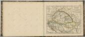
Austria-Hungary.
1 : 1774080 Stanford, Edward
[Galizien, Ungarn Slavonien und Croatien, Siebenbürgen und Dalmatien, Moldau, Wallachey]
Hand-Atlas über alle Theile der Erde nach dem neuesten Zustande und über das Weltgebäude Stieler, Adolf bei Justus Perthes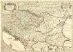
Le Royaume de Hongrie et les Estats qui en ont Esté sujets et qui font presentement la Partie Septentrionale de la Turquie en Europe.
1 : 2500000 Mollova mapová sbírka Sanson, Guillaume Cordier, Louis Jaillot, Alexis Hubert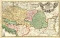
Eigentliche Vorstellung des so berühmten König. Reichs Ungarn neben Siebenbürgen, Moldau, Wallachey, Bosnien, und andern Ländern mehr bis an Constantinopel
1 : 1900000 Mollova mapová sbírka
Galizien, Ungarn mit Slavonien und Croatien, Siebenbürgen und Dalmatien, Moldau, Wallachey
1 : 3700000 Chorvatsko Justus Perthes
Austro-Hungarian Monarchy (eastern sheet).
1 : 1642000 Johnston, Alexander Keith
Eigentlliche Forstellung des soberühmten könig. Reichs Ungarn neben Sibenbürgen, Moldau, Wallachen, Bosnien und anderr Ländern mehr bis an Constantinopel
1 : 2000000 Bosna
Galizien, Ungarn mit Sclavonien und Croatien, Siebenbürgen und Dalmatien; Moldau, Walachey]
Stieler's Hand-Atlas Stieler, Adolf bei Justus Perthes