Maps of Westerwaldkreis

Nassau, Hessen-Homburg, Frankfurt.
1 : 344000 Flemming, Carl
Herzogthum Nassau, Landgrafschaft Hessen Homburg und die Freie Stadt Frankfurt
Grosser Hand-Atlas über alle Theile der Erde in 170 Karten Meyer, J. Verlag des Bibliographischen Instituts

Das Herzogthum Nassau
1 : 438000 Weimar : Verlag des Geographischen Instituts
Herzogthum Nassau
1 : 538200 Nasavsko Hoeckner, Carl aus der Schweinfurten Geographischen Gravirsanstalt des Bibliographischen Instituts
Charte vom Herzogthum Nassau
1 : 200000 Fembo, Christoph
Das Herzogthum Nassau
1 : 200000 Wimmer, Friedrich Scholz
Nassovia principatus, cum omnibus ei pertinentibus comitatibus dominiiis, ac praefecturis, ut et confiniis intrá Lahnum, Rhenum et Moenum flumina
1 : 1500000 ad situm verum exacte delineatus â Joh. Jac. Stetter [...] excudit Nic. Visscheri vidua Amstelodami : nunc apud Petrum Schenk Iunior
Nassovia Comitatus [Karte], in: Gerardi Mercatoris et I. Hondii Newer Atlas, oder, Grosses Weltbuch, Bd. 1, S. 200.
1 Karte aus Atlas Mercator, Gerhard und Hondius, Jodocus Jansson, Jan
Cursus Rheni a Basilea usque ad Archi-Episcopatum Coloniensem :
1 : 2900000 Mollova mapová sbírka Seutter, Matthäus Seutter, Matthäus
Mappa geographica exhibens principatum Nassoviae
1 : 172000 Nasavsko Lotter, Tobias Conrad Lotter, Georg F. sumptibus et curis Tobiae Conradi Lotter
Neue Topographische Carte Der Lahn von Marburg bis zu ihrem Einflus in den Rhein mit Bemerkung der in dieser Gegend vorgefallenen Kriegsbegebenheiten von 1795 und 1796
Brand, Peter; Thum, C.; Schalck, Anna Maria; Coentgen, Georg Joseph Brand u. Thum
NASSOVIA | Comitatus
Salomon Rogiers sculpsit [Amsterdam : Joan Blaeu]
Pars Vederoviae Plurimas Ditiones Princ. et Com. Nassovicor. imprimis verô Regionem Schwalbacensem Acidulis claram
1 : 170000 Mollova mapová sbírka Homann, Johann Baptist Homann, Johann Baptista
Principatus Nassaviae, divisus in speciales Comitatus, Nassaviam, Hadamariam, Beilstenium, Veilburgum, Dietziam, Usingam, Id Stanium, Dilemburgum et Sigenam ostenduntur
1 : 200000 Mollova mapová sbírka Valk, Gerhard Valck, Gerard
Pars Vederoviae plvrimas ditiones princ. et com. Nassovicor. imprimis verô regionem Schwalbacensem acidulis claram exhibens accurate distincta
Hesensko (Německo) Homann, Johann Baptist J. B. Homann
Nassovia Principatus
1 : 170000 Mollova mapová sbírka Stetter, Johann Jakob Schenk, Peter II
Frankfurt a.M. 99, uit: Special-Karte von Mittel-Europa / nach amtlichen Quellen bearbeitet von W. Liebenow
1 : 300000 titelvariant: W. Liebenow's Mittel-Europa; Annotatie: Titel boven de bladen: W. Liebenow's Mittel-Europa Johannes Wilhelm Liebenow 1822-1897 Frankfurt a. M. : Ludwig Ravenstein
Frankfurt 99, uit: [W. Liebenow's Special-Karte von Mittel-Europa]
1 : 300000 titelvariant: W. Liebenow's Mittel-Europa; Annotatie: Titel boven de bladen: W. Liebenow's Mittel-Europa Johannes Wilhelm Liebenow 1822-1897 Hannover : Hermann Oppermann
Nassovia Comitatvs
1 : 1300000 Mollova mapová sbírka Hondius, Henricus Hondius, Henricus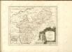

Les Environs De La Lahne depuis Marbvrg iusqu' à Ems avec les pais adiacents
1 : 200000
Partie Orientale Du Temporel De L'Archevesché et Eslectorat, De Treves
1 : 210000 Mollova mapová sbírka Sanson, Guillaume Jaillot, Alexis Hubert
Kriegs Theater der teutschen und franzoesischen Graenz Landen zwischen dem Rhein und der Mosel, im Jahr 1794
1 : 90000 Mosel (Německo) Dewarat, Peter Leizel, Balthasar Friedrich I.L.C. Rheinwald
Section Weilburg, uit: Charte von dem Grossherzogtum Hessen und dem Herzogtum Nassau / trigonometrisch aufgenommen und hrsg. von C.L.P. Eckhardt
1 : 200000 titelvariant: Karte von Hessen und Nassau Eckhardt, C. L. P Darmstadt : Joh. Wilh. Heyer
Partie Orientale du Temporel, de l'Archevesché et Eslectorat de Treves
1 : 220000 Mollova mapová sbírka Sanson, Guillaume Jaillot, Alexis Hubert
Nova et Accurata Moguntini Archiepiscopatus delineatio
1 : 620000 Mollova mapová sbírka Janssonius, Johannes Janssonius, Johannes I
161 Coblenz, uit: Topographische Special-Karte von Deutschland (von Central-Europa) / begründet von D.G. Reymann ; [entworfen und gezeichn. von Heinrich Berghaus... [et al.]]
1 : 200000 Annotatie: Lit.: Daniel Gottlob Reymann und die "Topographische Special-Karte von Deutschland" / von Wolfgang Scharfe, in: Kartographische Nachrichten, 39 (1989), Heft I, p. 1-10; Handgeschreven titel: Reymann's Deutschland : 24 Sectionen: Jena, Penig, Dresden, Zittau, Hirschberg, Breslau, Brieg, Andernach, Coblenz, Giessen, Fulda, Schleusingen, Plauen, Zwickau, Teplitz, Jung Bunzlau, Hohenelbe, Glatz, Neisse, Simmern, Prag, Luxemburg, Birkenfeld; Aanwezig: 23 bladen Reymann, Daniel Gottlob; Berghaus, Heinrich [Berlin : 2. Departement des Kriegsministeriums, Bureau für Plan- und Kartenzeichnung]
Partie Septentrionalo Des Pays qui sont Situéz Entre le Rhein la Saare, la Moselle, et la Basse Alsace
1 : 150000 Mollova mapová sbírka Mortier, Pieter Covens, Johannes I


