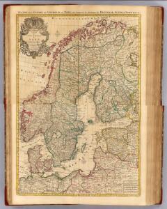
Maps of Scandinavia

Composite: Courones du nord.
1 : 2500000 L'Isle, Guillaume de, 1675-1726
Scandia, Scandinavia.
1 : 3050000 Faden, William, 1750?-1836
Suede, Norvege, Danemark.
1 : 4500000 Brue, Adrien Hubert, 1786-1832
Scandinavia.
1 : 4800000 Lizars, Daniel
Sweden, Denmark, Norway
1 : 7500000 Bowen, Frances
Composite: Courones du Nord.
1 : 2600000 L'Isle, Guillaume de, 1675-1726

Zweiter Theil der Karte von Europa welcher Dænemark, und Norwegen, Schweden, und Russland enthælt, 2
1 Blatt : 72 x 54 cm F.A. Schrämbl
Seconde partie de la carte d'Europe contenant le Danemark et la Norwege, la Suède et la Russie (a l'exeption de l'Ukraine), 2
1 Blatt : 71 x 53 cm chez l'auteur
Denmark, Sweden, Norway.
1 : 7900000 Tanner, Henry S.
Skandinavien oder Schweden und Norwegen
Schul-Atlas in 36 Karten Völter, Daniel Verlag der J.M. Dannheimer'schen Buchhandlung
[Neuer Atlas der ganzen Erde nach den neuesten Bestimmungen ... : XII.] Schweden, Norwegen und Daenemark
Nach den besten Materialien entworfen von F.W. Streit Leipzig : J.C. Hinrichssche Buchhandlung
Schweden, Norwegen.
1 : 6000000 Andree, Richard
Suede, Norvege, Danemark.
1 : 5400000 Garnier, F. A., 1803-1863
Suede, Norvege, et Danemark.
1 : 5900000 Monin, C.V.
Statistikk 42: Døgnets normaltemperatur i Skandinavia, oktober måned
1 : 4000000
Schweden, Norwegen und Dänemark
Schul-Atlas über alle Theile der Erde nach dem neuesten Zustande, und über das Weltgebäude Stieler, Adolf bei Justus Perthes
Statistikk 42: Døgnets normaltemperatur i Skandinavia, juli måned
1 : 4000000
[Scandinavien und Dänemark]
[Allgemeiner Atlas über alle Theile der Erde in 29 Blättern] Ziegler, Jakob Melchior Top. Anstalt v. J. Wurster u. Comp.
Statistikk 42: Døgnets normaltemperatur i Skandinavia, januar måned
1 : 4000000
Scandinavien bis zur calmarischen Union, 1397.
1 : 6000000 Spruner von Merz, Karl
[Schweden und Norwegen oder Scandinavische Halbinsel Königreich Daenemark]
Geographischer Atlas über alle Theile der Erde Ziegler, Jakob Melchior Verlag von Dietrich Reimer
Sweden and Norway
A new general atlas of modern geography, consisting of a complete collection of maps of the four quarters of the globe Wyld, James James Wyld
Charte von den Koenigreichen Daenemark, Schweden und Norwegen

Statistikk 42: Døgnets normaltemperatur i Skandinavia, april måned
1 : 4000000
Sweden & Norway.
1 : 7480000 Tanner, Henry S.
Nordeuropa 1991
Nordeuropa Kunz, Andreas ; Treiling, Thomas
Nordeuropa 1867
Nordeuropa Kunz, Andreas ; Röss, Wolf ; Johnen, Bettina ; Moeschl, Joachim Robert
Scandinavia.
1 : 3350000 Pinkerton, John, 1758-1826