Maps of Sahara

West Africa.
1 : 15000000 Colton, G.W.
Holland West Africa Lijn

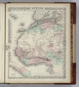
West Africa.
1 : 15000000 Colton, G.W.
Afrique du N.O.
1 : 10000000 Vivien St Martin, L.

West Africa.
1 : 18000000 Arrowsmith, Aaron; Lewis, Samuel
West Africa.
1 : 18000000 Arrowsmith, Aaron; Lewis, Samuel
Nordwestliches Afrika

North Western Africa.
1 : 15000000 Colton, G.W.
West Africa.
1 : 15000000 Colton, G.W.
North Western {LF}{LF}Africa
1 : 15000000 Colton, G.W.
Mittel-& Nord-Afrika, Westl. Theil.
1 : 14000000 Stulpnagel, F.v.
167-168. Africa, West. The World Atlas.
1 : 7500000 USSR (Union of Soviet Socialist Republics).
Carte de la Barbarie, le la Nigritie et de la Guinée
1 : 9375000 par Guillaume de L'Isle de l'Academie Royale des Sciences [S.l.] : [s.n.]
Carte de la Barbarie de la Nigritie et da le Guinée
1 : 9100000 Afrika severní Delisle, Guillaume Guillame del'Isle
Carte de la Barbarie [d]e la Nigritie et de la Guinée
1 : 9150000
Africa NW.
1 : 10000000 Andree, Richard; Times (London, England)
Nova Barbariae Descriptio. [Karte], in: Novus atlas absolutissimus, Bd. 6, S. 162.
1 Karte aus Atlas Janssonius Offizin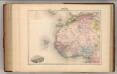
Afrique (Partie Nord-Ouest).
1 : 14400000 Migeon, J.

Das nordwestliche Africa
1 : 8000000 Afrika severozápadní Gräf, Carl Geographisches Institut
Carte de la Barbarie de la Nigritie et de la Guinée
1 : 9000000
[Mittel- und Nord-Africa, Westl. Theil]
Hand-Atlas über alle Theile der Erde nach dem neuesten Zustande und über das Weltgebäude Stieler, Adolf bei Justus Perthes
[Mittel- und Nord-Africa, Westl. Theil]
Hand-Atlas über alle Theile der Erde und über das Weltgebäude Stieler, Adolf Justus Perthes
[Mittel- und Nord-Africa und Arabien, Westliches Blatt]
Hand-Atlas über alle Theile der Erde nach dem neuesten Zustande und über das Weltgebäude Stieler, Adolf bei Justus Perthes
Mittel- & Nord-Afrika, Westl. Theil
Handatlas über alle Theile der Erde und über das Weltgebäude Stieler, Adolf Justus Perthes
Barbarie, Nigritie, Guinee.
1 : 9200000 L'Isle, Guillaume de, 1675-1726
Barbarie, Nigritie, Guinee.
1 : 9200000 L'Isle, Guillaume de, 1675-1726
Le Transsaharien, conférence de Mr Paul Soleillet. Carte du chemin de fer transsaharien
1 : 20850000 Société de géographie commerciale de Bordeaux Bordeaux : Société de Géographie Commerciale de Bordeaux